METAR & TAF 8U2
8U2 does not publish a METAR.
Showing the nearest reporting station: KGPI (GLACIER PARK INTL) · 42.8 NM away. Conditions at 8U2 may differ.
METAR · KGPI
Observed 07:55Z
KGPI 240755Z AUTO 00000KT 10SM CLR 12/08 A3012 RMK AO2 SLP193 T01220083
- Wind
- 000° @ 0 kt
- Visibility
- 10 SM
- Temp / Dew
- 12°C / 8°C
- Altimeter
- 30.12 inHg
- Clouds
- CLR
- Density alt
- 5,413 ft
- Ceiling
- Unlimited
- Rules
- VFR
Airport info & contacts
Manager on record, flight service, ARTCC, attendance schedule and pattern altitude — published by the FAA and refreshed every 28 days.
Location
- From city
- 15 NM SE
- VFR sectional
- GREAT FALLS
- ARTCC
- ZLC · SALT LAKE CITY
- NOTAM facility
- GTF (NOTAM-D)
Airport manager
- Name
- ADAM LADELL
- Phone
- 406-481-0826
- Address
- SPOTTED BEAR RANGER STATION, HUNGRY HORSE MT 59919
Flight service · Hours
- FSS GTF
- GREAT FALLS1-800-WX-BRIEF
- Attendance
- Unattended
Frequencies
Tap any row to copy the frequency to your clipboard.
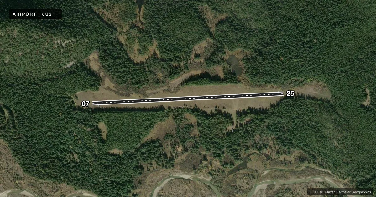
Runways & pattern
Full pagePattern entry · RWY 07
LEFT TRAFFICRunway end performance
| End | TORA | TODA | ASDA | LDA | VGSI | Approach lights | Obstruction |
|---|---|---|---|---|---|---|---|
| 07 | — | — | — | — | — | — | 55', trees, 300' from thr, 0' R of cntrln, slope 5 |
| 25 | — | — | — | — | — | — | 110', trees, 254' from thr, 60' R of cntrln, slope 2 |
Declared distances in feet. TORA = takeoff run available, TODA = takeoff distance, ASDA = accelerate-stop, LDA = landing distance.
Airport sketch
Runways drawn to scale from FAA survey coordinates, rendered over satellite imagery. Not for navigation.
Approaches & charts
Services on the field
Fuel grades, oxygen, maintenance, ramp storage and lighting — as declared to the FAA by the airport operator.
Fuel & services
- Fuel
- Not available
- Oxygen (bottled)
- Not available
- Oxygen (bulk)
- Not available
- Airframe repair
- Not available
- Power plant repair
- Not available
Ramp & ground
- Transient storage
- Tie-down
- Landing fee
- No fee published
- Wind indicator
- Yes
- Segmented circle
- No
Fuel & FBOs
Cheapest 100LL and Jet A on the field and nearby. Always confirm with the FBO before taxi.
Airport notes
Surface conditions, obstructions, local procedures, lighting outages and other notes published with each FAA cycle.
General notes
- LOW AREA NORTH SIDE OF RWY APROX 1100' FROM APP END RWY 25-USE CAUTION.
- WATCH FOR HORSES OR BIG GAME ANIMALS ON RY.
- TAKE OFF AND LAND RY 25 CONDITIONS PERMITTING.
- TREES AND TERRAIN IN TRANS SURFACE BOTH SIDES OF RY FULL LENGTH.
- PRIMARY PURPOSE OF A/S IS A TRAILHEAD FOR WILDERNESS AREAS.
- FOR CD CTC SALT LAKE ARTCC AT 801-320-2568.
Approach & departure obstructions
- 07RWY 07 FIRST 800 FT UNMARKED EXC THR.
- 25RUNWAY CONE WIDTH MAY VARY. FIRST 2400 FT MARKED WITH WHITE CONES 200 FT APART.
Other notes
- EST PRIOR TO 1959.
- MANAGERSUMMER PHONE 406-758-5376.
- 07/25FIRST 400 FT OF RY 25 IS UNEVEN-BOUNCY-ROUGH.
VFR map & nearby airports
VFR sectional. Tap any ICAO chip to open that airport.
Key facts · 8U2
Answer card- ICAO
- 8U2
- Name
- SCHAFER /USFS/
- Location
- SCHAFER, MONTANA
- Elevation
- 4,856 ft MSL
- Traffic pattern altitude
- 5,856 ft MSL (1,000 AGL)
- Control tower
- Non-towered (use CTAF)
- Total runways
- 1
- Longest runway
- 07/25 · 3,200 ft
- Published ILS approaches
- 0
- Published frequencies
- 1
- Magnetic variation
- 18°
- Current flight rules
- VFR
- Current wind
- 000° at 0 kt
- Favored runway now
- –
Schafer Airport (8U2) is in Schafer, Montana. The field elevation is 4,856 ft MSL. It has one runway. Runway 07/25 is 3,200 ft of turf, so plan for a short backcountry-style strip rather than a paved airport. There is no control tower. CTAF is 122.9.
No ILS approaches are published here. The pattern altitude is not published in the facts, so use the standard 1,000 ft AGL for light piston operations unless the current FAA Chart Supplement says otherwise. The airport sits in terrain with trees and terrain inside the transitional surface on both sides of the runway for the full length. That matters on climbout and on final.
Published remarks call out rough pavement? No. This field is turf. The first 400 ft of runway 25 is uneven, bouncy and rough. Runway 07 has the first 800 ft unmarked except for the threshold. Runway 25 may be used when conditions permit. Watch for horses or big game animals on the runway. The airport’s main purpose is as a trailhead for wilderness areas. There are no on-field FBOs listed. Call the airport operator directly before you go. For clearance delivery, contact Salt Lake ARTCC. Summer contact is listed in the remarks. Treat this as a high-elevation, terrain-sensitive strip and verify current conditions before departure.