METAR & TAF 0S1
0S1 does not publish a METAR.
Showing the nearest reporting station: KGPI (GLACIER PARK INTL) · 43.6 NM away. Conditions at 0S1 may differ.
METAR · KGPI
Observed 11:55Z
KGPI 271155Z AUTO 00000KT 10SM CLR 08/04 A3007 RMK AO2 SLP169 T00780044 10183 20078 53009 $
- Wind
- 000° @ 0 kt
- Visibility
- 10 SM
- Temp / Dew
- 8°C / 4°C
- Altimeter
- 30.07 inHg
- Clouds
- CLR
- Density alt
- 3,925 ft
- Ceiling
- Unlimited
- Rules
- VFR
Airport info & contacts
Manager on record, flight service, ARTCC, attendance schedule and pattern altitude — published by the FAA and refreshed every 28 days.
Location
- From city
- 1 NM NE
- VFR sectional
- GREAT FALLS
- ARTCC
- ZLC · SALT LAKE CITY
- NOTAM facility
- GTF (NOTAM-D)
Airport manager
- Name
- ADAM LADELL
- Phone
- 406-481-0826
- Address
- SPOTTED BEAR RANGER DIST, HUNGRY HORSE MT 59919
Flight service · Hours
- FSS GTF
- GREAT FALLS1-800-WX-BRIEF
- Attendance
- Unattended
Frequencies
Tap any row to copy the frequency to your clipboard.
Runways & pattern
Full pagePattern entry · RWY 17
LEFT TRAFFICRunway end performance
| End | TORA | TODA | ASDA | LDA | VGSI | Approach lights | Obstruction |
|---|---|---|---|---|---|---|---|
| 17 | — | — | — | — | — | — | 100', trees, 1100' from thr, 0' R of cntrln, slope 11 |
| 35 | — | — | — | — | — | — | 125', trees, 1000' from thr, 0' R of cntrln, slope 8 |
Declared distances in feet. TORA = takeoff run available, TODA = takeoff distance, ASDA = accelerate-stop, LDA = landing distance.
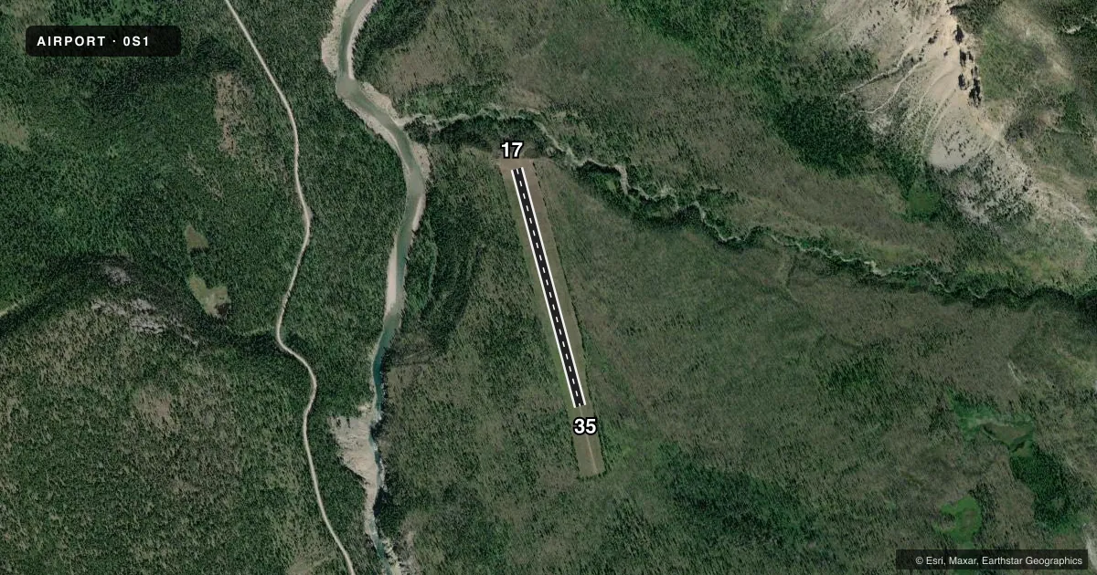
Airport sketch
Runways drawn to scale from FAA survey coordinates, rendered over satellite imagery. Not for navigation.
Approaches & charts
Services on the field
Fuel grades, oxygen, maintenance, ramp storage and lighting — as declared to the FAA by the airport operator.
Fuel & services
- Fuel
- Not available
- Oxygen (bottled)
- Not available
- Oxygen (bulk)
- Not available
- Airframe repair
- Not available
- Power plant repair
- Not available
Ramp & ground
- Transient storage
- Not published
- Landing fee
- No fee published
- Wind indicator
- Yes
- Segmented circle
- No
Fuel & FBOs
Cheapest 100LL and Jet A on the field and nearby. Always confirm with the FBO before taxi.
Airport notes
Surface conditions, obstructions, local procedures, lighting outages and other notes published with each FAA cycle.
General notes
- BIG GAME ANIMALS MAY BE ON RY.
- RY SFC MAY CONSIST OF TALL, WET GRASS.
- RY 17 HAS 900 FT OVERRUN AVBL FOR TKOF OR LDG.
- FOR CD CTC SALT LAKE ARTCC AT 801-320-2568.
- WATCH FOR GOPHER HOLES
- TREES & TRRN IN TRSN SFC BOTH SIDES OF RWY FULL LEN.
Approach & departure obstructions
- 17WHITE CONES MARKING FULL LENGHT OF RY.
- 35RY 17/35 MKD WITH WHITE CONES SPACED 200 FT.
Other notes
- ESTABLISHED PRIOR TO 1959
- MANAGERSUMMER NUMBER: 406-758-5376
VFR map & nearby airports
VFR sectional. Tap any ICAO chip to open that airport.
Key facts · 0S1
Answer card- ICAO
- 0S1
- Name
- MEADOW CREEK USFS
- Location
- MEADOW CREEK, MONTANA
- Elevation
- 3,993 ft MSL
- Traffic pattern altitude
- 4,993 ft MSL (1,000 AGL)
- Control tower
- Non-towered (use CTAF)
- Total runways
- 1
- Longest runway
- 17/35 · 2,830 ft
- Published ILS approaches
- 0
- Published frequencies
- 1
- Magnetic variation
- 18°
- Current flight rules
- VFR
- Current wind
- 000° at 0 kt
- Favored runway now
- –
Meadow Creek USFS is in Meadow Creek, Montana. The field elevation is 3,993 ft MSL. It has one runway, 17/35, which is 2,830 ft of turf. There is no control tower. CTAF is 122.9. No ILS approaches are published.
Pattern altitude is not published. Use the standard 1,000 ft AGL for light piston traffic unless the current Chart Supplement says otherwise. That puts the pattern at 4,993 ft MSL. The runway headings are magnetic. Runway 17 is marked with white cones along the full length. White cones are also used near the runway 35 end. Runway 17 has 900 ft of overrun available for takeoff or landing.
This is a mountain field with trees and terrain in the transition surface on both sides of the runway. The runway surface may be tall, wet grass. Watch for gopher holes. Big game animals may be on the runway. There are no on-field FBOs listed. For current services, contact the airport operator or the FBO directly by phone. The airport was established before 1959. For clearance delivery, contact Salt Lake ARTCC at 801-320-2568.