METAR & TAF 8U4
8U4 does not publish a METAR.
Showing the nearest reporting station: KGPI (GLACIER PARK INTL) · 34.9 NM away. Conditions at 8U4 may differ.
METAR · KGPI
Observed 12:55Z
KGPI 271255Z AUTO 00000KT 10SM CLR 07/06 A3007 RMK AO2 SLP173 T00720056
- Wind
- 000° @ 0 kt
- Visibility
- 10 SM
- Temp / Dew
- 7°C / 6°C
- Altimeter
- 30.07 inHg
- Clouds
- CLR
- Density alt
- 3,407 ft
- Ceiling
- Unlimited
- Rules
- VFR
Airport info & contacts
Manager on record, flight service, ARTCC, attendance schedule and pattern altitude — published by the FAA and refreshed every 28 days.
Location
- From city
- 3 NM NW
- VFR sectional
- GREAT FALLS
- ARTCC
- ZLC · SALT LAKE CITY
- NOTAM facility
- GTF (NOTAM-D)
Airport manager
- Name
- ADAM LADELL
- Phone
- 406-481-0826
- Address
- SPOTTED BEAR RANGER STATION, HUNGRY HORSE MT 59919
Flight service · Hours
- FSS GTF
- GREAT FALLS1-800-WX-BRIEF
- Attendance
- Unattended
Frequencies
Tap any row to copy the frequency to your clipboard.
Runways & pattern
Full pagePattern entry · RWY 14
LEFT TRAFFICRunway end performance
| End | TORA | TODA | ASDA | LDA | VGSI | Approach lights | Obstruction |
|---|---|---|---|---|---|---|---|
| 14 | — | — | — | — | — | — | 60', trees, 430' from thr, 0' R of cntrln, slope 7 |
| 32 | — | — | — | — | — | — | 90', trees, 800' from thr, 0' R of cntrln, slope 8 |
Declared distances in feet. TORA = takeoff run available, TODA = takeoff distance, ASDA = accelerate-stop, LDA = landing distance.
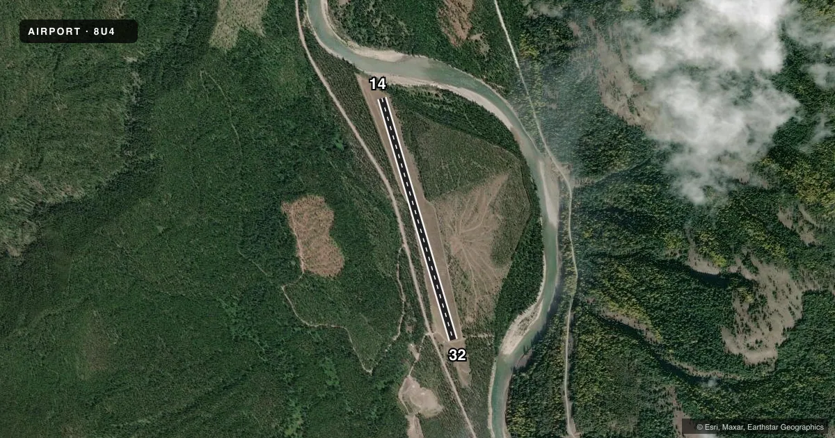
Airport sketch
Runways drawn to scale from FAA survey coordinates, rendered over satellite imagery. Not for navigation.
Approaches & charts
Services on the field
Fuel grades, oxygen, maintenance, ramp storage and lighting — as declared to the FAA by the airport operator.
Fuel & services
- Fuel
- Not available
- Oxygen (bottled)
- Not available
- Oxygen (bulk)
- Not available
- Airframe repair
- Not available
- Power plant repair
- Not available
Ramp & ground
- Transient storage
- Tie-down
- Buoy
- Landing fee
- No fee published
- Wind indicator
- Yes
- Segmented circle
- No
Fuel & FBOs
Cheapest 100LL and Jet A on the field and nearby. Always confirm with the FBO before taxi.
Airport notes
Surface conditions, obstructions, local procedures, lighting outages and other notes published with each FAA cycle.
General notes
- MOUNTAINS & TREES IN TRNSTN AREA BOTH SIDES OF RY.
- FONE IN RANGER STN OR AT RANCH 1 MI S OF ARPT.
- FOR CD CTC SALT LAKE ARTCC AT 801-320-2568.
Runway surface & condition
- 14/32N QTR OF STRIP HAS A SLGT DOG-LEG; DOG-LEG BGNS 1800 FT FM N END.
Approach & departure obstructions
- 14FIRST 1400 FT OF RWY 14 NOT MKD WITH CONES.
- 32RY 32 FIRST 2400 FT MKD WITH CONES SPACED 200 FT APART.
Other notes
- EST PRIOR TO 1959.
- MANAGERSUMMER PHONE: 406-758-5376
- 14/32UP TO 4 INCH ROCK ON RY SFC.
VFR map & nearby airports
VFR sectional. Tap any ICAO chip to open that airport.
Key facts · 8U4
Answer card- ICAO
- 8U4
- Name
- SPOTTED BEAR /USFS/
- Location
- SPOTTED BEAR, MONTANA
- Elevation
- 3,672 ft MSL
- Traffic pattern altitude
- 4,672 ft MSL (1,000 AGL)
- Control tower
- Non-towered (use CTAF)
- Total runways
- 1
- Longest runway
- 14/32 · 3,800 ft
- Published ILS approaches
- 0
- Published frequencies
- 1
- Magnetic variation
- 18°
- Current flight rules
- VFR
- Current wind
- 000° at 0 kt
- Favored runway now
- –
Spotted Bear /USFS/ (8U4) sits in Spotted Bear, Montana. The field elevation is 3,672 ft MSL. It has one runway. Runway 14/32 is 3,800 ft long with a turf-gravel surface. There is no control tower. CTAF is 122.9.
No ILS approaches are published here. Pattern altitude is not published in the facts. Use the standard 1,000 ft AGL pattern unless the current Chart Supplement says otherwise. The airport sits in mountain country. Mountains and trees are in the transition area on both sides of the runway. That matters on arrival and departure, especially with the elevation and the terrain around the strip.
Published remarks call out a slight dog-leg in the north quarter of the runway. The dog-leg begins 1,800 ft from the north end. Runway 32 has cones for the first 2,400 ft. Runway 14 has no cones on the first 1,400 ft. There is up to 4 inch rock on the runway surface. The airport was established before 1959. A phone is available in the ranger station or at the ranch one mile south of the airport. The summer phone number is 406-758-5376. For clearance delivery contact Salt Lake ARTCC at 801-320-2568.