METAR & TAF 53U
53U does not publish a METAR.
Showing the nearest reporting station: KGPI (GLACIER PARK INTL) · 18.1 NM away. Conditions at 53U may differ.
METAR · KGPI
Observed 12:55Z
KGPI 271255Z AUTO 00000KT 10SM CLR 07/06 A3007 RMK AO2 SLP173 T00720056
- Wind
- 000° @ 0 kt
- Visibility
- 10 SM
- Temp / Dew
- 7°C / 6°C
- Altimeter
- 30.07 inHg
- Clouds
- CLR
- Density alt
- 2,663 ft
- Ceiling
- Unlimited
- Rules
- VFR
Airport info & contacts
Manager on record, flight service, ARTCC, attendance schedule and pattern altitude — published by the FAA and refreshed every 28 days.
Location
- From city
- 3 NM NE
- VFR sectional
- GREAT FALLS
- ARTCC
- ZLC · SALT LAKE CITY
- NOTAM facility
- GTF (NOTAM-D)
Airport manager
- Name
- ROB RATKOWSKI
- Phone
- 406-257-5994
- Address
- 4170 HIGHWAY 2-E, KALISPELL MT 59901
Flight service · Hours
- FSS GTF
- GREAT FALLS1-800-WX-BRIEF
- Attendance
- Unattended
Frequencies
Tap any row to copy the frequency to your clipboard.
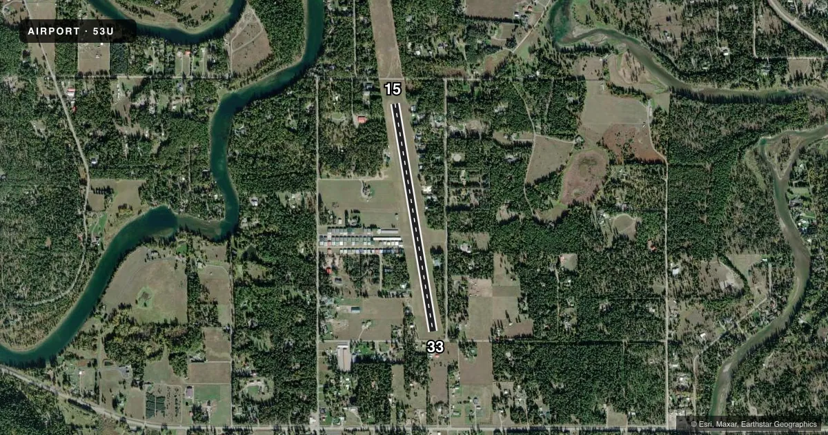
Runways & pattern
Full pagePattern entry · RWY 15
LEFT TRAFFICRunway end performance
| End | TORA | TODA | ASDA | LDA | VGSI | Approach lights | Obstruction |
|---|---|---|---|---|---|---|---|
| 15 | — | — | — | — | — | — | 100', trees, 477' from thr, 400' R of cntrln, slope 4 |
| 33 | — | — | — | — | — | — | 100', trees, 600' from thr, 115' R of cntrln, slope 6 |
Declared distances in feet. TORA = takeoff run available, TODA = takeoff distance, ASDA = accelerate-stop, LDA = landing distance.
Airport sketch
Runways drawn to scale from FAA survey coordinates, rendered over satellite imagery. Not for navigation.
Approaches & charts
Services on the field
Fuel grades, oxygen, maintenance, ramp storage and lighting — as declared to the FAA by the airport operator.
Fuel & services
- Fuel
- Not available
- Oxygen (bottled)
- Not available
- Oxygen (bulk)
- Not available
- Airframe repair
- Major
- Power plant repair
- Major
Ramp & ground
- Transient storage
- Tie-down
- Landing fee
- No fee published
- Wind indicator
- Yes
- Segmented circle
- No
Fuel & FBOs
Cheapest 100LL and Jet A on the field and nearby. Always confirm with the FBO before taxi.
Airport notes
Surface conditions, obstructions, local procedures, lighting outages and other notes published with each FAA cycle.
General notes
- SNOW REMOVAL MAY BE DELAYED CALL FOR CONDITIONS 406-257-5994.
- RWY 15 +100 FT TREES 1570 FT FM END OF RWY ON CNTRLN; RWY 33 +80 FT TREES 1500 FT FM END OF RWY; RWY 15 +15 FT ROAD 250 FT FM END OF RWY ON CNTRLN.
- TREES IN TRANSITION SFC BOTH SIDES OF RY FULL LENGTH.
- FREE BICYCLES FOR ARPT USE LCTD IN STORAGE SHED. TO ACCESS USE EMERG FREQ ON LOCK.
- RWY 33 +50 FT TREE ON CNTRLN 500 FT FM END OF RWY AT 10:1.
- FOR CD CTC SALT LAKE ARTCC AT 801-320-2568.
Approach & departure obstructions
- 1515/33 NSTD MARKINGS - WHITE CONES MARK FULL RY LENGTH. RED TRAFFIC CONES MARK EACH RY THRESHOLD WITH 100 FOOT DISPLACED THRESHOLD
Other notes
- CALL FOR RPRS: 406-253-5688
- PROVIDED COMPATIBLE INGRESS/EGRESS ARE ESTABLISHED IN ORDER TO AVOID CONGESTED AREAS AND ASSUME SAFETY TO PERSONS AND PROPERTY ON THE SURFACE.
- DEP PROC STRAIGHT OUT THRU TPA OF 4072 FT MSL (1000 FT AGL).
VFR map & nearby airports
VFR sectional. Tap any ICAO chip to open that airport.
Key facts · 53U
Answer card- ICAO
- 53U
- Name
- FERNDALE AIRFIELD
- Location
- BIGFORK, MONTANA
- Elevation
- 3,072 ft MSL
- Traffic pattern altitude
- 4,072 ft MSL (1,000 AGL)
- Control tower
- Non-towered (use CTAF)
- Total runways
- 1
- Longest runway
- 15/33 · 3,500 ft
- Published ILS approaches
- 0
- Published frequencies
- 1
- Magnetic variation
- 18°
- Current flight rules
- VFR
- Current wind
- 000° at 0 kt
- Favored runway now
- –
Ferndale Airfield (53U) sits near Bigfork, Montana. The field elevation is 3,072 ft MSL. It has one runway. Runway 15/33 is 3,500 ft of turf, with magnetic headings of 171° and 351°. There is no control tower. CTAF is 122.9. No ILS approaches are published here.
The published pattern altitude is 4,072 ft MSL. That is 1,000 ft AGL. The airport sits in terrain where trees matter. Published remarks call out trees in the transition surface on both sides of the runway for the full length. They also note trees and a road near the runway ends. Runway 15 has a displaced threshold. Runway 33 does too. Snow removal may be delayed, so call ahead for current conditions before you launch.
There are no on-field FBOs listed in the facts. If you need services, contact the airport operator or call the field directly before arrival. For departure planning, the published note says to go straight out through pattern altitude. Clearance delivery is handled through Salt Lake ARTCC when needed. The field also has free airport bicycles in a storage shed, with access through the emergency frequency on the lock.