METAR & TAF KGPI
Current METAR
Observed 15:55Z
KGPI 271555Z 00000KT 10SM CLR 17/08 A3009 RMK AO2 SLP175 T01720078
- Wind
- 000° @ 0 kt
- Visibility
- 10 SM
- Temp / Dew
- 17°C / 8°C
- Altimeter
- 30.09 inHg
- Clouds
- CLR
- Density alt
- 3,720 ft
- Ceiling
- Unlimited
- Rules
- VFR
Airport info & contacts
Manager on record, flight service, ARTCC, attendance schedule and pattern altitude — published by the FAA and refreshed every 28 days.
Location
- From city
- 6 NM NE
- VFR sectional
- GREAT FALLS
- ARTCC
- ZLC · SALT LAKE CITY
- NOTAM facility
- GPI (NOTAM-D)
Airport manager
- Name
- ROB RATKOWSKI
- Phone
- 406-257-5994
- Address
- 4170 HWY 2, KALISPELL MT 59901
Flight service · Hours
- FSS GTF
- GREAT FALLS1-800-WX-BRIEF
- Attendance
- ALL
Frequencies
Tap any row to copy the frequency to your clipboard.
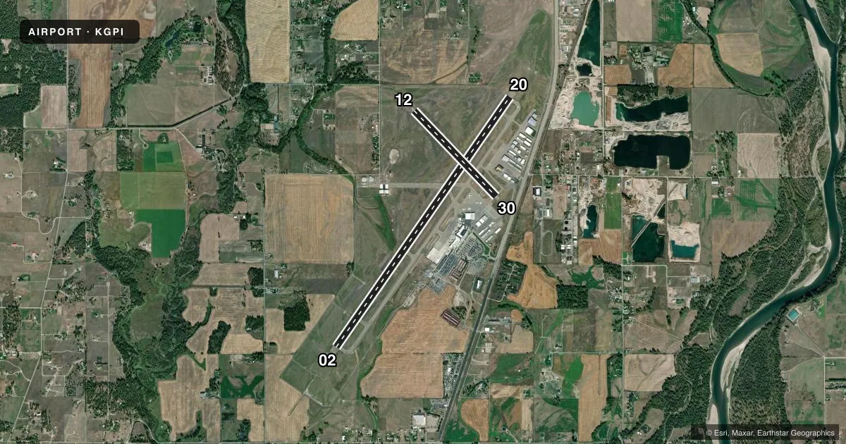
Runways & pattern
Full pagePattern entry · RWY 02
LEFT TRAFFIC| Runway | Heading (°M) | Length | Surface | Traffic |
|---|---|---|---|---|
| 02/20 | 20° / 200° | 9,007 ft | ASPH | Standard L |
| 12/30 | 121° / 301° | 3,510 ft | ASPH | Standard L |
Runway end performance
| End | TORA | TODA | ASDA | LDA | VGSI | Approach lights | Obstruction |
|---|---|---|---|---|---|---|---|
| 02 | 9,007' | 9,007' | 9,007' | 9,007' | PAPI 4-box left(3°) | MALSR | — |
| 20 | 9,007' | 9,007' | 9,007' | 9,007' | PAPI 4-box left(3°) | — | — |
| 12 | 3,510' | 3,510' | 3,510' | 3,510' | — | — | — |
| 30 | 3,510' | 3,510' | 3,510' | 3,510' | PAPI 2-box left(3.5°) | — | — |
Declared distances in feet. TORA = takeoff run available, TODA = takeoff distance, ASDA = accelerate-stop, LDA = landing distance.
Airport sketch
Runways drawn to scale from FAA survey coordinates, rendered over satellite imagery. Not for navigation.
Approaches & charts
ILS · 1
Services on the field
Fuel grades, oxygen, maintenance, ramp storage and lighting — as declared to the FAA by the airport operator.
Fuel & services
- Fuel
- 100LLA
- Oxygen (bulk)
- HIGH/LOW
- Airframe repair
- Major
- Power plant repair
- Major
- Other services
- AVNCS,CHTR,INSTR,RNTL,SURV
Ramp & ground
- Transient storage
- Tie-down
- Hangar
- Landing fee
- Yes
- Customs
- Not available
- Lighting schedule
- SEE RMK
- Beacon schedule
- SS-SR
- Beacon
- White / Green (civil land)(WG)
- Wind indicator
- Lighted
- Segmented circle
- Yes
Fuel & FBOs
Cheapest 100LL and Jet A on the field and nearby. Always confirm with the FBO before taxi.
Airport notes
Surface conditions, obstructions, local procedures, lighting outages and other notes published with each FAA cycle.
General notes
- COLD TEMPERATURE AIRPORT. ALTITUDE CORRECTION REQUIRED AT OR BELOW -14C.
- CTN: SKYDIVING OPS 6 NM NW 13000 FT & BLW SR-SS JUN-SEP. PAJA STATUS - SALT LAKE ARTCC.
- CTN: VFR TFC OPS AT KALISPELL CITY ARPT 8 NM S & WHITEFISH ARPT 6 NM NW.
- ARFF INDEX C FOR SKED INDEX C ACR OPS; OTHERWISE, ARFF INDEX B EXC 30 MIN PPR.
Lighting notes
- ACTVT MALSR RWY 02; REIL RWY 20; HIRL RWY 02/20; MIRL RWY 12/30 - CTAF. PAPI RWY 02, 20 & 30 OPR CONSLY.
Runway surface & condition
- 02/20PCR VALUE: 513/F/B/X/T
- 12/30PCR VALUE: 80/F/C/X/T
Other notes
- CLSD TO UNSKED ACR OPS MORE THAN 30 PAX SEATS EXC PPR - AMGR.
VFR map & nearby airports
VFR sectional. Tap any ICAO chip to open that airport.
Key facts · KGPI
Answer card- ICAO
- KGPI
- Name
- GLACIER PARK INTL
- Location
- KALISPELL, MONTANA
- Elevation
- 2,976.8 ft MSL
- Traffic pattern altitude
- 3,976.8 ft MSL (1,000 AGL)
- Control tower
- Towered · 0800-0000
- Total runways
- 2
- Longest runway
- 02/20 · 9,007 ft
- Published ILS approaches
- 1
- Published frequencies
- 5
- Magnetic variation
- 15°
- Current flight rules
- VFR
- Current wind
- 000° at 0 kt
- Favored runway now
- –
Glacier Park Intl is in Kalispell, Montana. Field elevation is 2,976.8 ft MSL. The airport has two asphalt runways. The longest is 02/20 at 9,007 ft. Runway 12/30 is 3,510 ft. The tower is open 0800-0000. One ILS is published. It serves runway 02.
Pattern altitude is not published. Use the standard 1,000 ft AGL for light piston traffic unless ATC or local procedures say otherwise. Atlantic Aviation is on the field. It carries 100LL, Jet A and Jet A Prist. Call (406) 755-5362 for current service details.
A few operational notes matter here. The field is a cold temperature airport. Altitude correction is required at or below minus 14 degrees C. The airport also has published lighting on the main runway. Runway 02 has approach lighting with runway alignment indicator lights. Runway 20 has runway end identifier lights. High intensity lights are on 02 and 20. Runway 12/30 uses medium intensity lights controlled by CTAF. There is also skydiving activity 6 NM northwest from June through September. Watch for VFR traffic near Kalispell City Airport 8 NM south and Whitefish Airport 6 NM northwest. Check the current FAA Chart Supplement for any noise or curfew restrictions before flying into the field.