METAR & TAF KSBX
Current METAR
Observed 12:15Z
KSBX 271215Z AUTO 32005KT 10SM CLR 14/03 A3004 RMK AO2
- Wind
- 320° @ 5 kt
- Visibility
- 10 SM
- Temp / Dew
- 14°C / 3°C
- Altimeter
- 30.04 inHg
- Clouds
- CLR
- Density alt
- 4,000 ft
- Ceiling
- Unlimited
- Rules
- VFR
Airport info & contacts
Manager on record, flight service, ARTCC, attendance schedule and pattern altitude — published by the FAA and refreshed every 28 days.
Location
- From city
- 2 NM N
- VFR sectional
- GREAT FALLS
- ARTCC
- ZLC · SALT LAKE CITY
- NOTAM facility
- GTF (NOTAM-D)
Airport manager
- Name
- JERRY LARSON JR
- Phone
- (406) 450-2463
- Address
- PO BOX 210, SHELBY MT 59474
Flight service · Hours
- FSS GTF
- GREAT FALLS1-800-WX-BRIEF
- Attendance
- MON-FRI · 0800-1800
Frequencies
Tap any row to copy the frequency to your clipboard.
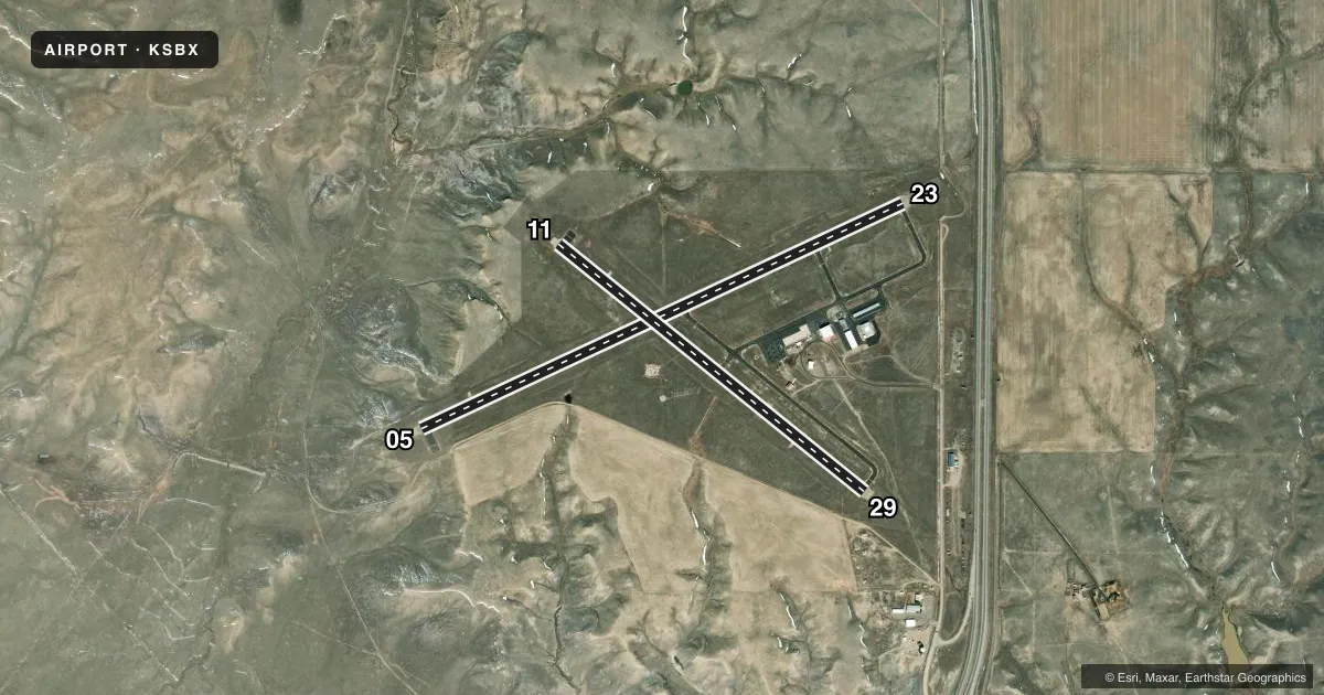
Runways & pattern
Full pagePattern entry · RWY 29
LEFT TRAFFIC| Runway | Heading (°M) | Length | Surface | Traffic |
|---|---|---|---|---|
| 05/23 | 50° / 230° | 5,005 ft | ASPH | Standard L |
| 11/29Favored | 114° / 294° | 3,701 ft | ASPH | Standard L |
Runway end performance
| End | TORA | TODA | ASDA | LDA | VGSI | Approach lights | Obstruction |
|---|---|---|---|---|---|---|---|
| 05 | — | — | — | — | PAPI 2-box left(3°) | — | — |
| 23 | — | — | — | — | PAPI 2-box left(3°) | — | — |
| 11 | — | — | — | — | PAPI 2-box left(3°) | — | — |
| 29 | — | — | — | — | PAPI 2-box left(3°) | — | — |
Declared distances in feet. TORA = takeoff run available, TODA = takeoff distance, ASDA = accelerate-stop, LDA = landing distance.
Airport sketch
Runways drawn to scale from FAA survey coordinates, rendered over satellite imagery. Not for navigation.
Approaches & charts
Services on the field
Fuel grades, oxygen, maintenance, ramp storage and lighting — as declared to the FAA by the airport operator.
Fuel & services
- Fuel
- 100LLA+
- Oxygen (bottled)
- Not available
- Oxygen (bulk)
- Not available
- Airframe repair
- Not available
- Power plant repair
- Not available
- Other services
- AGRI,INSTR,RNTL
Ramp & ground
- Transient storage
- Tie-down
- Landing fee
- No fee published
- Customs
- Not available
- Lighting schedule
- SEE RMK
- Beacon schedule
- SS-SR
- Beacon
- White / Green (civil land)(WG)
- Wind indicator
- Lighted
- Segmented circle
- Yes
Fuel & FBOs
Cheapest 100LL and Jet A on the field and nearby. Always confirm with the FBO before taxi.
Airport notes
Surface conditions, obstructions, local procedures, lighting outages and other notes published with each FAA cycle.
General notes
- DEER ON & INVOF ARPT.
- TWY EDGES MKD WITH REFLECTORS.
- FOR CD CTC SALT LAKE ARTCC AT 801-320-2568.
Lighting notes
- ACTVT PAPI RWY 05 & 23; MIRL RWY 05/23 & 11/29-CTAF.
Fuel notes
- 100LLFOR FUEL AFTER HRS CALL 406-450-2461 OR 406-450-2463. SELF SVC CREDIT CARD FOR 100LL & JET A+. FUEL TRUCK AVBL FOR JET A+.
VFR map & nearby airports
VFR sectional. Tap any ICAO chip to open that airport.
Key facts · KSBX
Answer card- ICAO
- KSBX
- Name
- SHELBY
- Location
- SHELBY, MONTANA
- Elevation
- 3,442.9 ft MSL
- Traffic pattern altitude
- 4,442.9 ft MSL (1,000 AGL)
- Control tower
- Non-towered (use CTAF)
- Total runways
- 2
- Longest runway
- 05/23 · 5,005 ft
- Published ILS approaches
- 0
- Published frequencies
- 2
- Magnetic variation
- 15°
- Current flight rules
- VFR
- Current wind
- 320° at 5 kt
- Favored runway now
- RWY 29
Shelby Airport is in Shelby, Montana. The field elevation is 3,442.9 ft MSL. It has two asphalt runways. The longest is runway 05/23 at 5,005 ft. There is no control tower. CTAF and UNICOM are both 122.8.
No ILS approaches are published here. Pattern altitude is not published, so use the standard 1,000 ft AGL for light piston traffic unless the current Chart Supplement says otherwise. Larson Flying Service is on the field. It carries 100LL and Jet A Prist. For after-hours fuel, the published remarks list phone numbers to call. Self-serve credit card fuel is available for 100LL and Jet A+. The remarks also note that runway 05 and 23 have active PAPI. Medium intensity runway lights are published for both runways and are controlled by CTAF.
This is a high-elevation airport, so performance planning matters. Deer are reported on and near the airport. Taxiway edges are marked with reflectors. For clearance delivery, contact Salt Lake ARTCC. Check the current Chart Supplement for any local procedures or restrictions before you go.