METAR & TAF 7S8
7S8 does not publish a METAR.
Showing the nearest reporting station: KSBX (SHELBY) · 27.8 NM away. Conditions at 7S8 may differ.
METAR · KSBX
Observed 22:55Z
KSBX 242255Z AUTO 26015G30KT 10SM CLR 35/06 A2988 RMK AO2
- Wind
- 260° @ 15G30 kt
- Visibility
- 10 SM
- Temp / Dew
- 35°C / 6°C
- Altimeter
- 29.88 inHg
- Clouds
- CLR
- Density alt
- 6,855 ft
- Ceiling
- Unlimited
- Rules
- VFR
Airport info & contacts
Manager on record, flight service, ARTCC, attendance schedule and pattern altitude — published by the FAA and refreshed every 28 days.
Location
- From city
- 1 NM W
- VFR sectional
- GREAT FALLS
- ARTCC
- ZLC · SALT LAKE CITY
- NOTAM facility
- GTF (NOTAM-D)
Airport manager
- Name
- TIM CONWAY
- Phone
- 406-444-2506
- Address
- PO BOX 200507, HELENA MT 59620-0507
Flight service · Hours
- FSS GTF
- GREAT FALLS1-800-WX-BRIEF
- Attendance
- Unattended
Frequencies
Tap any row to copy the frequency to your clipboard.
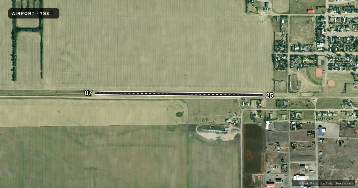
Runways & pattern
Full pagePattern entry · RWY 25
LEFT TRAFFICAirport sketch
Runways drawn to scale from FAA survey coordinates, rendered over satellite imagery. Not for navigation.
Approaches & charts
Services on the field
Fuel grades, oxygen, maintenance, ramp storage and lighting — as declared to the FAA by the airport operator.
Fuel & services
- Fuel
- Not available
Ramp & ground
- Transient storage
- Tie-down
- Landing fee
- No fee published
- Customs
- Not available
- Wind indicator
- Yes
- Segmented circle
- Yes
Fuel & FBOs
Cheapest 100LL and Jet A on the field and nearby. Always confirm with the FBO before taxi.
Airport notes
Surface conditions, obstructions, local procedures, lighting outages and other notes published with each FAA cycle.
General notes
- +30 FT TREES, +18 FT BLDGS & +4 FT FENCES BOTH SIDES OF TWY & RWY IN TRSN SFC BGNG 405 FT W OF RWY 25 TO RWY 25 THR.
- NO SNOW REMOVAL.
- FOR CD CTC SALT LAKE ARTCC AT 801-320-2568.
- ROAD PARL TO RWY ON U.S. SIDE.
- TWY HAS RUTS. TWY LNDG OR TKOF NA.
Approach & departure obstructions
- 25+22 FT FENCE 62 FT R & 515 FT FM RWY END; PENETRATES APCH SFC.
- 07THR MKD BY DOUBLE CONES; EDGE MKD BY WHITE CONES SPACED 200 FT FULL LEN.
- 25THR MKD BY DOUBLE CONES; EDGE MKD BY WHITE CONES SPACED 200 FT FULL LEN.
- 07PWR LN XG TWY 2180 FT FM RWY 25 END.
Other notes
- IN U.S. CUST OFC.
- 07/25MUDDY WHEN WET; GOPHER HOLES; RUTS E END.
VFR map & nearby airports
VFR sectional. Tap any ICAO chip to open that airport.
Key facts · 7S8
Answer card- ICAO
- 7S8
- Name
- ROSS INTL
- Location
- SWEETGRASS, MONTANA
- Elevation
- 3,553 ft MSL
- Traffic pattern altitude
- 4,553 ft MSL (1,000 AGL)
- Control tower
- Non-towered (use CTAF)
- Total runways
- 1
- Longest runway
- 07/25 · 2,900 ft
- Published ILS approaches
- 0
- Published frequencies
- 2
- Magnetic variation
- 18°
- Current flight rules
- VFR
- Current wind
- 260° at 15 kt
- Favored runway now
- RWY 25
Ross Intl is in Sweetgrass, Montana. Field elevation is 3,553 ft MSL. The airport has one runway. Runway 07/25 is 2,900 ft of turf, so plan for soft-field handling and a longer ground roll than a paved strip. There is no control tower. CTAF and UNICOM are both 122.8. No ILS approaches are published.
Pattern altitude is not published. For light piston operations, use the standard 1,000 ft AGL unless the current FAA Chart Supplement says otherwise. The published remarks matter here. The runway can be muddy when wet. The east end has gopher holes and ruts. No snow removal is provided. Taxiway use is limited too. Taxiway landing or takeoff is not authorized. There is also a road parallel to the runway on the U.S. side. Keep a close eye outside on final and in the pattern.
Runway 25 has a fence near the approach path. Runway 07 has its threshold marked by double cones. The field has no on-field FBOs listed. For clearance delivery, contact Salt Lake ARTCC at 801-320-2568. If you are planning a first visit, verify current field conditions before departure. The combination of turf, ruts, obstructions and no snow removal makes this a strip where a careful preflight and a good walk-around matter.