METAR & TAF 3U5
3U5 does not publish a METAR.
Showing the nearest reporting station: KGTF (GREAT FALLS INTL) · 41.0 NM away. Conditions at 3U5 may differ.
METAR · KGTF
Observed 10:53Z
KGTF 261053Z AUTO 18003KT 10SM BKN060 OVC080 18/07 A2998 RMK AO2 SLP107 T01830067 $
- Wind
- 180° @ 3 kt
- Visibility
- 10 SM
- Temp / Dew
- 18°C / 7°C
- Altimeter
- 29.98 inHg
- Clouds
- OVC
- Density alt
- 5,425 ft
- Ceiling
- 6,000 ft AGL
- Rules
- VFR
Airport info & contacts
Manager on record, flight service, ARTCC, attendance schedule and pattern altitude — published by the FAA and refreshed every 28 days.
Location
- From city
- 2 NM SE
- VFR sectional
- GREAT FALLS
- ARTCC
- ZLC · SALT LAKE CITY
- NOTAM facility
- GTF (NOTAM-D)
Airport manager
- Name
- TIM CONWAY
- Phone
- 406-444-2506
- Address
- PO BOX 200507, HELENA MT 59620-0507
Flight service · Hours
- FSS GTF
- GREAT FALLS1-800-WX-BRIEF
- Attendance
- Unattended
Frequencies
Tap any row to copy the frequency to your clipboard.
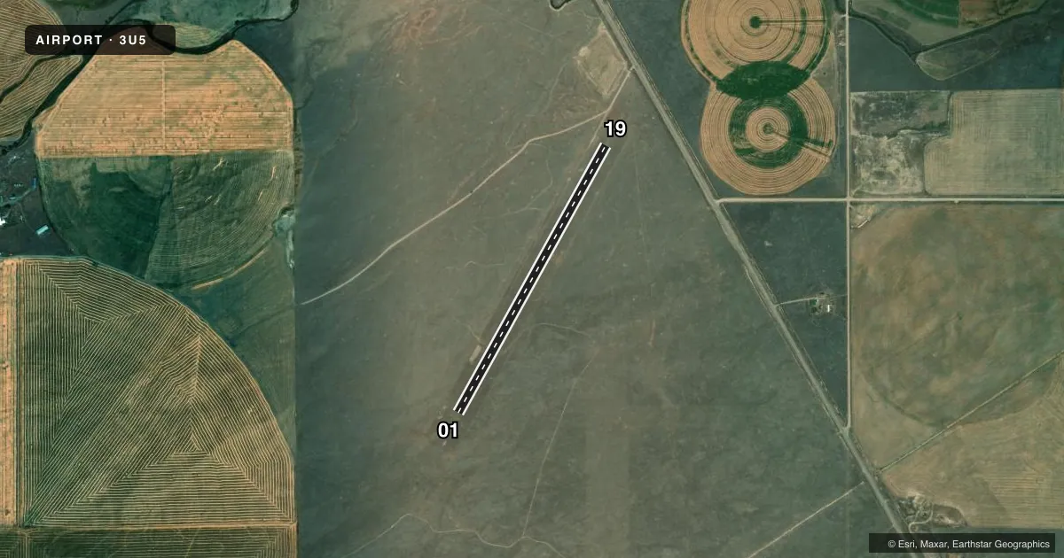
Runways & pattern
Full pagePattern entry · RWY 19
LEFT TRAFFICAirport sketch
Runways drawn to scale from FAA survey coordinates, rendered over satellite imagery. Not for navigation.
Approaches & charts
Services on the field
Fuel grades, oxygen, maintenance, ramp storage and lighting — as declared to the FAA by the airport operator.
Fuel & services
- Fuel
- Not available
- Oxygen (bottled)
- Not available
- Oxygen (bulk)
- Not available
- Airframe repair
- Not available
- Power plant repair
- Not available
Ramp & ground
- Transient storage
- Tie-down
- Landing fee
- No fee published
- Wind indicator
- Yes
- Segmented circle
- Yes
Fuel & FBOs
Cheapest 100LL and Jet A on the field and nearby. Always confirm with the FBO before taxi.
Airport notes
Surface conditions, obstructions, local procedures, lighting outages and other notes published with each FAA cycle.
General notes
- UNLIMITED VEHICLE ACCESS TO ARPT.
- WILDLIFE ON & INVOF ARPT INCLUDING RATTLESNAKES.
- FOR CD CTC SALT LAKE ARTCC AT 801-320-2568.
- NO SN REMOVAL
- SHOOTING RANGE ADJ TO ARPT.
Approach & departure obstructions
- 01MKD WITH W CONES.
- 19MKD WITH W CONES.
Other notes
- 01/19GOPHER HOLES ON RWY SFC.
VFR map & nearby airports
VFR sectional. Tap any ICAO chip to open that airport.
Key facts · 3U5
Answer card- ICAO
- 3U5
- Name
- AUGUSTA
- Location
- AUGUSTA, MONTANA
- Elevation
- 4,145 ft MSL
- Traffic pattern altitude
- 5,145 ft MSL (1,000 AGL)
- Control tower
- Non-towered (use CTAF)
- Total runways
- 1
- Longest runway
- 01/19 · 3,650 ft
- Published ILS approaches
- 0
- Published frequencies
- 1
- Magnetic variation
- 17°
- Current flight rules
- VFR
- Current wind
- 180° at 3 kt
- Favored runway now
- RWY 19
Augusta Airport (3U5) sits in Augusta, Montana. The field elevation is 4,145 ft MSL. It has one runway. Runway 01/19 is 3,650 ft long and surfaced with turf. The airport is not towered. CTAF is 122.9.
No ILS approaches are published here. Pattern altitude is not published, so use the standard 1,000 ft AGL pattern unless the current Chart Supplement says otherwise. That puts the light aircraft pattern at 5,145 ft MSL. The runway is marked with white cones at both ends. Published remarks also note gopher holes on the runway surface. That makes a careful walk-around and a good look at the turf smart before landing.
Wildlife is present on and near the airport. Rattlesnakes are specifically mentioned. There is also a shooting range adjacent to the field. No snow removal is provided. Vehicle access is unlimited. There are no on-field FBOs listed, so verify services with the airport operator or call the field on CTAF before you go. For clearance delivery, contact Salt Lake ARTCC at 801-320-2568. At this elevation, expect mountain-field performance to matter on warm days. Check density altitude before departure.