METAR & TAF KBIL
Current METAR
Observed 05:53Z
KBIL 270553Z 31010G27KT 10SM -RA FEW035 SCT060 BKN130 BKN200 26/13 A2999 RMK AO2 PK WND 28035/0533 WSHFT 0527 RAB46 SLP109 OCNL LTGICCG CB DSNT W-NW P0000 60001 T02610133 10339 20233 55015
- Wind
- 310° @ 10G27 kt
- Visibility
- 10 SM
- Temp / Dew
- 26°C / 13°C
- Altimeter
- 29.99 inHg
- Clouds
- BKN
- Density alt
- 5,774 ft
- Ceiling
- 13,000 ft AGL
- Rules
- VFR
Airport info & contacts
Manager on record, flight service, ARTCC, attendance schedule and pattern altitude — published by the FAA and refreshed every 28 days.
Location
- From city
- 2 NM NW
- VFR sectional
- BILLINGS
- ARTCC
- ZLC · SALT LAKE CITY
- NOTAM facility
- BIL (NOTAM-D)
Airport manager
- Name
- JEFF ROACH, MANAGER
- Phone
- (406) 657-8484
- Address
- 1901 TERMINAL CIRCLE DR., ROOM 216, BILLINGS MT 59105
Flight service · Hours
- FSS GTF
- GREAT FALLS1-800-WX-BRIEF
- Attendance
- ALL
Frequencies
Tap any row to copy the frequency to your clipboard.
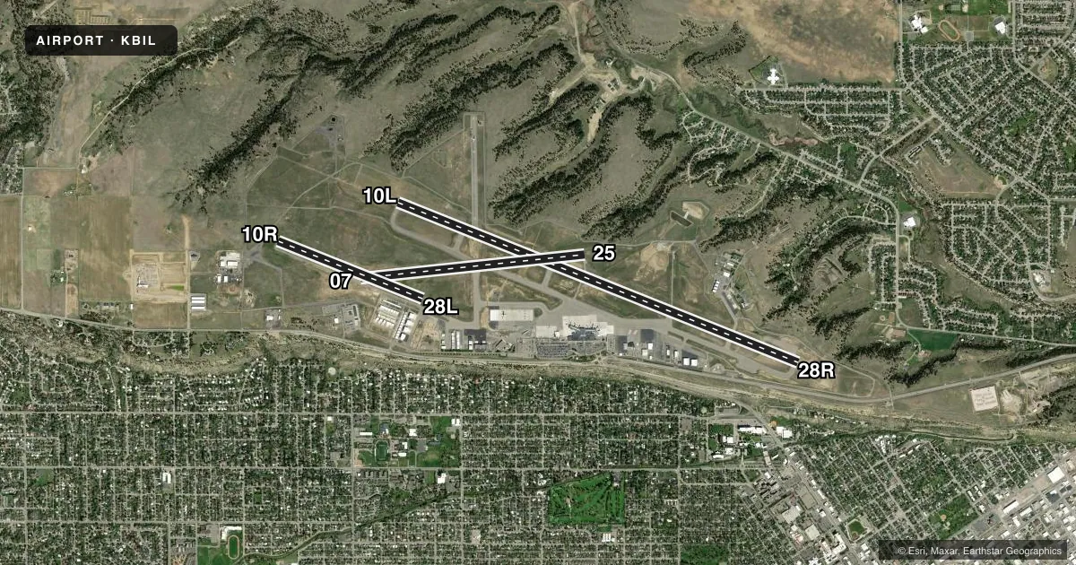
Runways & pattern
Full pagePattern entry · RWY 28R
LEFT TRAFFIC| Runway | Heading (°M) | Length | Surface | Traffic |
|---|---|---|---|---|
| 10L/28RFavored | 101° / 281° | 10,518 ft | ASPH | Standard L |
| 07/25 | 74° / 254° | 5,501 ft | ASPH | Standard L |
| 10R/28L | 101° / 281° | 3,800 ft | ASPH | Standard L |
Runway end performance
| End | TORA | TODA | ASDA | LDA | VGSI | Approach lights | Obstruction |
|---|---|---|---|---|---|---|---|
| 10L | 10,518' | 10,518' | 10,518' | 10,518' | PAPI 4-box left(3°) | MALSR | — |
| 28R | 10,518' | 10,518' | 10,518' | 10,518' | PAPI 4-box right(3°) | — | 12', gnd, 200' from thr, 400' R of cntrln, slope 34 |
| 07 | 5,501' | 5,501' | 5,501' | 5,501' | PAPI 4-box left(3°) | — | 20', gnd, 600' from thr, 0' R of cntrln, slope 20 |
| 25 | 5,501' | 5,501' | 5,501' | 5,501' | PAPI 4-box right(3°) | — | — |
| 10R | 3,801' | 3,801' | 3,801' | 3,801' | — | — | 52', gnd, 2251' from thr, 0' R of cntrln, slope 20 |
| 28L | 3,801' | 3,801' | 3,801' | 3,801' | — | — | — |
Declared distances in feet. TORA = takeoff run available, TODA = takeoff distance, ASDA = accelerate-stop, LDA = landing distance.
Airport sketch
Runways drawn to scale from FAA survey coordinates, rendered over satellite imagery. Not for navigation.
Approaches & charts
ILS · 2
Services on the field
Fuel grades, oxygen, maintenance, ramp storage and lighting — as declared to the FAA by the airport operator.
Fuel & services
- Fuel
- 100LLA
- Oxygen (bottled)
- HIGH/LOW
- Oxygen (bulk)
- HIGH/LOW
- Airframe repair
- Major
- Power plant repair
- Major
- Other services
- AFRT,AMB,AVNCS,CARGO,CHTR,INSTR,RNTL,SALES
Ramp & ground
- Transient storage
- Tie-down
- Hangar
- Landing fee
- No fee published
- Customs
- Not available
- Lighting schedule
- SEE RMK
- Beacon schedule
- SS-SR
- Beacon
- White / Green (civil land)(WG)
- Wind indicator
- Lighted
- Segmented circle
- Yes
Fuel & FBOs
Cheapest 100LL and Jet A on the field and nearby. Always confirm with the FBO before taxi.
Airport notes
Surface conditions, obstructions, local procedures, lighting outages and other notes published with each FAA cycle.
General notes
- 180 DEG TURNS PROHIBITED ON ALL SFCS.
- MIGRATORY WATERFOWL INVOF ARPT.
- RYS 07/25 AND 10R/28L CLSD TO ACFT OVER 12,500 LBS.
- TWY D 35 FT WIDE CLSD TO ACFT OVER 12,500 LBS.
- NO CUSTOMS, REMOTE ACFT PARKING, LTD GROUND HANDLING SVCS
- PILOTS CONDUCTING EFVS OPS; BE AWARE LED ALS IN USE RWY 10L.
Lighting notes
- ATC-CTL. FOR MIRL RYS 10R/28L & 07/25; HIRL RY 10L/28R; MALSR RY 10L & REIL RYS 25 & 28R - CTC ATCT.
Runway surface & condition
- 07/25PCR VALUE: 303/F/B/X/T
- 10L/28RPCR VALUE: 745/F/B/X/T
- 10R/28LPCR VALUE: 107/F/B/X/T
Approach & departure obstructions
- 28R+12' GND 0-200' FM RY END 400' L.
Other notes
- PPR UNSKED ACR OPNS WITH MORE THAN 30 PSGR SEATS CTC ARPT OPS 406-657-8496. ARFF INDEX B 0200-0500.
- SINGLE ENGINE ACFT 4500 (838), MULTI ENGINE/TURBOJET ACFT 5000 (1338).
- MANAGER406-657-8495
VFR map & nearby airports
VFR sectional. Tap any ICAO chip to open that airport.
Key facts · KBIL
Answer card- ICAO
- KBIL
- Name
- BILLINGS LOGAN INTL
- Location
- BILLINGS, MONTANA
- Elevation
- 3,662.3 ft MSL
- Traffic pattern altitude
- 4,662.3 ft MSL (1,000 AGL)
- Control tower
- Towered · 24
- Total runways
- 3
- Longest runway
- 10L/28R · 10,518 ft
- Published ILS approaches
- 2
- Published frequencies
- 14
- Magnetic variation
- 10°
- Current flight rules
- VFR
- Current wind
- 310° at 10 kt
- Favored runway now
- RWY 28R
Billings Logan Intl sits in Billings, Montana at 3,662.3 ft MSL. It has three asphalt runways. The longest is 10,518 ft on 10L/28R. The field is towered 24 hours. Two ILS approaches are published. They serve runway ends 10L and 28R.
The airport is in Class C airspace. Expect normal tower and approach control work for a busy regional field. Pattern altitude is not published in the facts. Use 4,500 ft MSL for single-engine traffic. Use 5,000 ft MSL for multi-engine and turbojet traffic. That puts the single-engine pattern at 838 ft AGL. Multi-engine and turbojet traffic is 1,338 ft AGL.
Edwards Jet Center is on the field. It carries 100LL, Jet A and Jet A Prist. Beacon Air Group is also on the field. It carries 100LL, Jet A and Jet A Prist. The airport remarks call out migratory waterfowl in the area. They also say 180 degree turns are prohibited on all surfaces. Runways 07/25 and 10R/28L are closed to aircraft over 12,500 pounds. Taxiway D is also closed to aircraft over 12,500 pounds. If you are operating a larger aircraft or planning an unscheduled air carrier arrival, check with airport operations before you go.