METAR & TAF 00U
Current METAR
Observed 03:35Z
K00U 270335Z AUTO 23012KT 10SM SCT048 BKN060 OVC095 28/14 A2996 RMK A01
- Wind
- 230° @ 12 kt
- Visibility
- 10 SM
- Temp / Dew
- 28°C / 14°C
- Altimeter
- 29.96 inHg
- Clouds
- OVC
- Density alt
- 5,262 ft
- Ceiling
- 6,000 ft AGL
- Rules
- VFR
Airport info & contacts
Manager on record, flight service, ARTCC, attendance schedule and pattern altitude — published by the FAA and refreshed every 28 days.
Location
- From city
- 3 NM W
- VFR sectional
- BILLINGS
- ARTCC
- ZLC · SALT LAKE CITY
- NOTAM facility
- GTF (NOTAM-D)
Airport manager
- Name
- CRAIG MEHLING
- Phone
- 406-860-2020
- Address
- PO BOX 908, HARDIN MT 59034
Flight service · Hours
- FSS GTF
- GREAT FALLS1-800-WX-BRIEF
- Attendance
- Unattended
Frequencies
Tap any row to copy the frequency to your clipboard.
Runways & pattern
Full pagePattern entry · RWY 26
LEFT TRAFFICRunway end performance
| End | TORA | TODA | ASDA | LDA | VGSI | Approach lights | Obstruction |
|---|---|---|---|---|---|---|---|
| 08 | — | — | — | — | PAPI 2-box left(3°) | — | — |
| 26 | — | — | — | — | PAPI 2-box left(3°) | — | — |
Declared distances in feet. TORA = takeoff run available, TODA = takeoff distance, ASDA = accelerate-stop, LDA = landing distance.
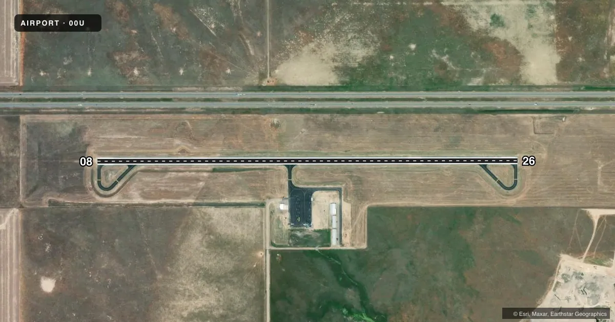
Airport sketch
Runways drawn to scale from FAA survey coordinates, rendered over satellite imagery. Not for navigation.
Approaches & charts
Services on the field
Fuel grades, oxygen, maintenance, ramp storage and lighting — as declared to the FAA by the airport operator.
Fuel & services
- Fuel
- 100LL
Ramp & ground
- Transient storage
- Not published
- Lighting schedule
- SEE RMK
- Beacon schedule
- SEE RMK
- Beacon
- White / Green (civil land)(WG)
- Wind indicator
- Lighted
- Segmented circle
- Yes
Fuel & FBOs
Cheapest 100LL and Jet A on the field and nearby. Always confirm with the FBO before taxi.
Airport notes
Surface conditions, obstructions, local procedures, lighting outages and other notes published with each FAA cycle.
General notes
- FOR CD CTC BILLINGS APCH AT 406-255-2798
Lighting notes
- ACTVT CTAF
- ACTVT PAPI RWY 8 & 26; MIRL RWY 8/26 - CTAF.
VFR map & nearby airports
VFR sectional. Tap any ICAO chip to open that airport.
Key facts · 00U
Answer card- ICAO
- 00U
- Name
- BIG HORN COUNTY
- Location
- HARDIN, MONTANA
- Elevation
- 3,025.3 ft MSL
- Traffic pattern altitude
- 4,025.3 ft MSL (1,000 AGL)
- Control tower
- Non-towered (use CTAF)
- Total runways
- 1
- Longest runway
- 08/26 · 4,491 ft
- Published ILS approaches
- 0
- Published frequencies
- 2
- Magnetic variation
- 10°
- Current flight rules
- VFR
- Current wind
- 230° at 12 kt
- Favored runway now
- RWY 26
Big Horn County Airport sits near Hardin, Montana at 3,025.3 ft MSL. It has one runway. Runway 08/26 is 4,491 ft of asphalt, so plan performance with the field elevation in mind. The airport is non-towered. CTAF and UNICOM are both 122.8. No ILS approaches are published here.
Pattern altitude is not published. Use 1,000 ft AGL for light piston operations unless the current Chart Supplement says otherwise. That puts the pattern at about 4,025 ft MSL. The magnetic variation is 10°. Published remarks note that the PAPI and medium intensity runway lights for runways 08 and 26 are activated by the CTAF. That is useful after sunset or in low light. For clearance delivery, contact Billings Approach at 406-255-2798.
There are no on-field FBOs listed in the facts. Contact the airport operator directly before arrival if you need fuel or ramp details. This is a simple field with one runway. The main things to watch are the elevation. The lack of published ILS matters too. The lighting activation method is also worth briefed before arrival.