METAR & TAF 3U4
3U4 does not publish a METAR.
Showing the nearest reporting station: KMLS (FRANK WILEY FLD) · 51.8 NM away. Conditions at 3U4 may differ.
METAR · KMLS
Observed 12:53Z
KMLS 271253Z AUTO 01007KT 4SM HZ CLR 23/07 A2987 RMK AO2 SLP087 T02280067
- Wind
- 010° @ 7 kt
- Visibility
- 4 SM
- Temp / Dew
- 23°C / 7°C
- Altimeter
- 29.87 inHg
- Clouds
- CLR
- Density alt
- 4,629 ft
- Ceiling
- Unlimited
- Rules
- MVFR
Airport info & contacts
Manager on record, flight service, ARTCC, attendance schedule and pattern altitude — published by the FAA and refreshed every 28 days.
Location
- From city
- 1 NM NW
- VFR sectional
- BILLINGS
- ARTCC
- ZLC · SALT LAKE CITY
- NOTAM facility
- GTF (NOTAM-D)
Airport manager
- Name
- STEVE VANN
- Phone
- 406-784-4965
- Address
- PO BOX 77, 112 ST LABRE CAMPUS DR, 112 CAMPUS ROAD, ASHLAND MT 59003
Flight service · Hours
- FSS GTF
- GREAT FALLS1-800-WX-BRIEF
- Attendance
- Unattended
Frequencies
Tap any row to copy the frequency to your clipboard.
Runways & pattern
Full pagePattern entry · RWY 31
LEFT TRAFFICRunway end performance
| End | TORA | TODA | ASDA | LDA | VGSI | Approach lights | Obstruction |
|---|---|---|---|---|---|---|---|
| 13 | — | — | — | — | — | — | 52', tree, 114' from thr, 33' R of cntrln, slope 2 |
| 31 | — | — | — | — | — | — | 52', tree, 125' from thr, 10' R of cntrln, slope 2 |
Declared distances in feet. TORA = takeoff run available, TODA = takeoff distance, ASDA = accelerate-stop, LDA = landing distance.
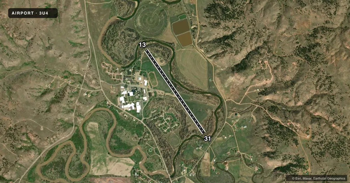
Airport sketch
Runways drawn to scale from FAA survey coordinates, rendered over satellite imagery. Not for navigation.
Approaches & charts
Services on the field
Fuel grades, oxygen, maintenance, ramp storage and lighting — as declared to the FAA by the airport operator.
Fuel & services
- Fuel
- Not available
- Oxygen (bottled)
- Not available
- Oxygen (bulk)
- Not available
- Airframe repair
- Not available
- Power plant repair
- Not available
Ramp & ground
- Transient storage
- Tie-down
- Landing fee
- No fee published
- Customs
- Not available
- Wind indicator
- Yes
- Segmented circle
- No
Fuel & FBOs
Cheapest 100LL and Jet A on the field and nearby. Always confirm with the FBO before taxi.
Airport notes
Surface conditions, obstructions, local procedures, lighting outages and other notes published with each FAA cycle.
General notes
- VEHICLES & HORSES INVOF RY.
- 100' LIGHTED ANTENNA 1/2 MILE SW OF ARPT ON HILL.
- NUMEROUS TREES ON E SIDE OF RY FULL LENGTH TO +60 FT IN TRANSITIONAL SURFACES.
- RY 31 -8' TERRAIN DROPOFF BEGINNING 35' FM EOR WITH DENSE BRUSH.
- RY 13 HAS -10 FT TERRAIN DROPOFF BEGINNING 15 FT FM EOR WITH DENSE BRUSH CREEK.
- RY 13/31 1 FT TO 2 FT DIRT BERM ON EDGE OF RY AND THLDS.
- FOR CD CTC SALT LAKE ARTCC AT 801-320-2568.
Runway surface & condition
- 13/31MUDDY WHEN WET.
Approach & departure obstructions
- 13RY 31 NUMEROUS TREES IN BOTH APCH SFCS WITHIN 180' OF RY ENDS.
Other notes
- PROVIDE OWN ROPES.
- MANAGER406-477-6625 AT NIGHT OR 406-983-4500.
VFR map & nearby airports
VFR sectional. Tap any ICAO chip to open that airport.
Key facts · 3U4
Answer card- ICAO
- 3U4
- Name
- ST LABRE MISSION
- Location
- ASHLAND, MONTANA
- Elevation
- 2,909 ft MSL
- Traffic pattern altitude
- 3,909 ft MSL (1,000 AGL)
- Control tower
- Non-towered (use CTAF)
- Total runways
- 1
- Longest runway
- 13/31 · 3,830 ft
- Published ILS approaches
- 0
- Published frequencies
- 2
- Magnetic variation
- 13°
- Current flight rules
- MVFR
- Current wind
- 010° at 7 kt
- Favored runway now
- RWY 31
ST LABRE MISSION (3U4) sits in Ashland, Montana at 2,909 ft MSL. The airport has one runway, 13/31, which is 3,830 ft long with a gravel-dirt surface. There is no control tower. CTAF and UNICOM are both 122.8. No ILS approaches are published here.
Pattern altitude is not published. Use 1,000 ft AGL as the standard light-piston pattern reference unless the current FAA Chart Supplement says otherwise. That puts the pattern at 3,909 ft MSL based on the listed field elevation. The runway environment needs a close look before arrival. Trees line the east side of the runway for much of its length. Runway 31 has trees close in both approach surfaces within 180 ft of the runway ends. Runway 13 has a terrain dropoff, brush and a creek just beyond the end. Runway 31 also has a terrain dropoff and brush beyond the end. The runway can be muddy when wet.
No on-field FBOs are listed. Plan to verify services with the airport operator or the FBO directly by phone before you go. Published remarks also note vehicles and horses in the vicinity of the runway. Clearance delivery is handled through Salt Lake ARTCC. The airport is a simple backcountry-style strip with a few real hazards near the pavement. A first-time pilot should treat the departure and landing ends with extra caution.