METAR & TAF M46
M46 does not publish a METAR.
Showing the nearest reporting station: KMLS (FRANK WILEY FLD) · 48.5 NM away. Conditions at M46 may differ.
METAR · KMLS
Observed 22:53Z
KMLS 242253Z AUTO 07006KT 10SM SCT075 22/08 A3011 RMK AO2 SLP190 T02220083
- Wind
- 070° @ 6 kt
- Visibility
- 10 SM
- Temp / Dew
- 22°C / 8°C
- Altimeter
- 30.11 inHg
- Clouds
- SCT
- Density alt
- 4,855 ft
- Ceiling
- Unlimited
- Rules
- VFR
Airport info & contacts
Manager on record, flight service, ARTCC, attendance schedule and pattern altitude — published by the FAA and refreshed every 28 days.
Location
- From city
- 3 NM SW
- VFR sectional
- BILLINGS
- ARTCC
- ZLC · SALT LAKE CITY
- NOTAM facility
- GTF (NOTAM-D)
Airport manager
- Name
- BRIAN SCHWEND
- Phone
- 406-351-1261
- Address
- PO BOX 45, FORSYTH MT 59327
Flight service · Hours
- FSS GTF
- GREAT FALLS1-800-WX-BRIEF
- Attendance
- ON CALL
Frequencies
Tap any row to copy the frequency to your clipboard.
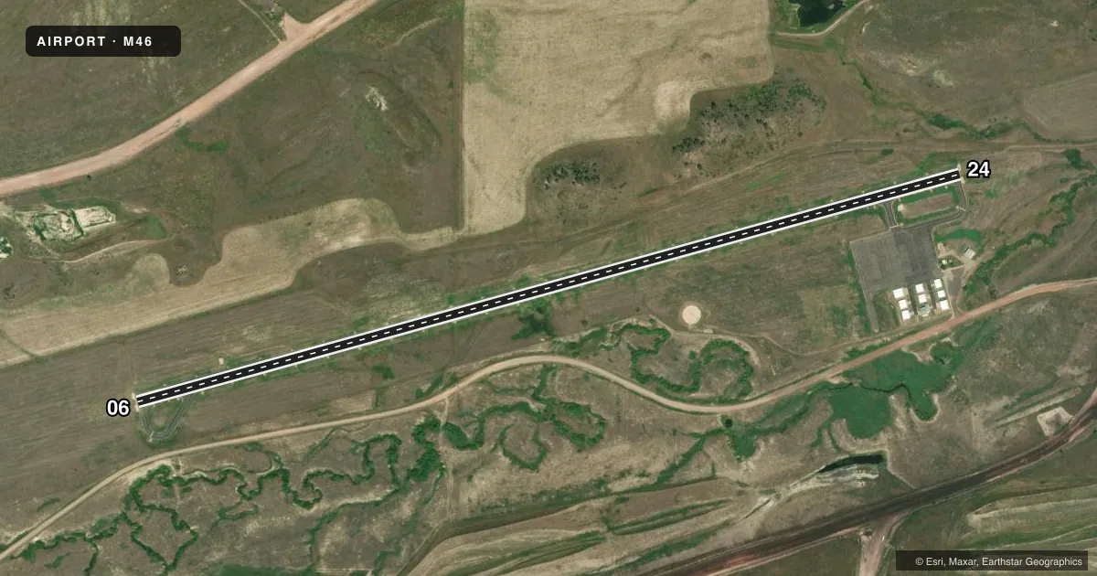
Runways & pattern
Full pagePattern entry · RWY 06
LEFT TRAFFICRunway end performance
| End | TORA | TODA | ASDA | LDA | VGSI | Approach lights | Obstruction |
|---|---|---|---|---|---|---|---|
| 06 | — | — | — | — | PAPI 2-box left(3°) | — | — |
| 24 | — | — | — | — | PAPI 2-box left(3°) | — | — |
Declared distances in feet. TORA = takeoff run available, TODA = takeoff distance, ASDA = accelerate-stop, LDA = landing distance.
Airport sketch
Runways drawn to scale from FAA survey coordinates, rendered over satellite imagery. Not for navigation.
Approaches & charts
Services on the field
Fuel grades, oxygen, maintenance, ramp storage and lighting — as declared to the FAA by the airport operator.
Fuel & services
- Fuel
- Not available
Ramp & ground
- Transient storage
- Tie-down
- Lighting schedule
- SEE RMK
- Beacon schedule
- SS-SR
- Beacon
- White / Green (civil land)(WG)
- Wind indicator
- Lighted
- Segmented circle
- Yes
Fuel & FBOs
Cheapest 100LL and Jet A on the field and nearby. Always confirm with the FBO before taxi.
Airport notes
Surface conditions, obstructions, local procedures, lighting outages and other notes published with each FAA cycle.
General notes
- HILL 1550' FM RY 24 END 600' LEFT & 93' ABOVE RY THR.
- 700 FT POWER PLANT STACKS 4.5 NM NE OF ARPT.
- PHONE AVAIL ON ARPT.
- COLD TEMPERATURE AIRPORT. ALTITUDE CORRECTION REQUIRED AT OR BELOW -34C.
- FOR CD CTC SALT LAKE ARTCC AT 801-320-2568.
Lighting notes
- ACTVT PAPI 06 & 24 - CTAF; MIRL RWY 06/24 PRESET LOW INTST DUSK-0100; AFT 0100 ACTVT - CTAF.
VFR map & nearby airports
VFR sectional. Tap any ICAO chip to open that airport.
Key facts · M46
Answer card- ICAO
- M46
- Name
- COLSTRIP
- Location
- COLSTRIP, MONTANA
- Elevation
- 3,427.6 ft MSL
- Traffic pattern altitude
- 4,427.6 ft MSL (1,000 AGL)
- Control tower
- Non-towered (use CTAF)
- Total runways
- 1
- Longest runway
- 06/24 · 5,100 ft
- Published ILS approaches
- 0
- Published frequencies
- 2
- Magnetic variation
- 13°
- Current flight rules
- VFR
- Current wind
- 070° at 6 kt
- Favored runway now
- RWY 06
Colstrip Airport sits in Colstrip, Montana. The field elevation is 3,427.6 ft MSL. It has one runway. Runway 06/24 is 5,100 ft long with an asphalt surface. The airport is non-towered. CTAF and UNICOM are both 122.7. No ILS approaches are published here.
The pattern altitude is not published, so use the standard 1,000 ft AGL pattern unless local guidance says otherwise. That puts the light piston pattern at about 4,428 ft MSL. Check the current FAA Chart Supplement before you go if you need to confirm any local procedure. The published remarks also call out a hill near the Runway 24 end. It sits 1,550 ft from the threshold, 600 ft left of centerline and 93 ft above the runway threshold. There are also 700 ft power plant stacks 4.5 NM northeast of the airport. This is a cold temperature airport. Altitude correction is required at or below minus 34 C. A phone is available on the airport. There are no on-field FBOs listed. Contact the airport operator directly or call the field on CTAF for current fuel and service availability before arrival.