METAR & TAF 00F
00F does not publish a METAR.
Showing the nearest reporting station: KMLS (FRANK WILEY FLD) · 60.2 NM away. Conditions at 00F may differ.
METAR · KMLS
Observed 15:53Z
KMLS 271553Z AUTO VRB04KT 5SM HZ CLR 30/08 A2990 RMK AO2 SLP096 T03000078
- Wind
- VAR @ 4 kt
- Visibility
- 5 SM
- Temp / Dew
- 30°C / 8°C
- Altimeter
- 29.90 inHg
- Clouds
- CLR
- Density alt
- 5,894 ft
- Ceiling
- Unlimited
- Rules
- MVFR
Airport info & contacts
Manager on record, flight service, ARTCC, attendance schedule and pattern altitude — published by the FAA and refreshed every 28 days.
Location
- From city
- 3 NM NW
- VFR sectional
- BILLINGS
- ARTCC
- ZLC · SALT LAKE CITY
- NOTAM facility
- GTF (NOTAM-D)
Airport manager
- Name
- JOHN OLSON
- Phone
- 406-853-6448
- Address
- PO BOX 424, BROADUS MT 59317
Flight service · Hours
- FSS GTF
- GREAT FALLS1-800-WX-BRIEF
- Attendance
- Unattended
Frequencies
Tap any row to copy the frequency to your clipboard.
Runways & pattern
Full pagePattern entry · RWY 28
LEFT TRAFFICRunway end performance
| End | TORA | TODA | ASDA | LDA | VGSI | Approach lights | Obstruction |
|---|---|---|---|---|---|---|---|
| 10 | — | — | — | — | PAPI 2-box left(3°) | — | — |
| 28 | — | — | — | — | PAPI 2-box left(3°) | — | — |
Declared distances in feet. TORA = takeoff run available, TODA = takeoff distance, ASDA = accelerate-stop, LDA = landing distance.
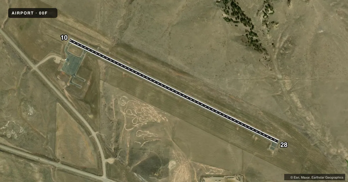
Airport sketch
Runways drawn to scale from FAA survey coordinates, rendered over satellite imagery. Not for navigation.
Approaches & charts
Services on the field
Fuel grades, oxygen, maintenance, ramp storage and lighting — as declared to the FAA by the airport operator.
Fuel & services
- Fuel
- 100LLA
Ramp & ground
- Transient storage
- Tie-down
- Lighting schedule
- SEE RMK
- Beacon schedule
- SS-SR
- Beacon
- White / Green (civil land)(WG)
- Wind indicator
- Lighted
- Segmented circle
- No
Fuel & FBOs
Cheapest 100LL and Jet A on the field and nearby. Always confirm with the FBO before taxi.
Airport notes
Surface conditions, obstructions, local procedures, lighting outages and other notes published with each FAA cycle.
General notes
- FOR CD CTC SALT LAKE ARTCC AT 801-320-2568.
Lighting notes
- PAPI RY 10 AND RY 28; MIRL RY 10/28 OPER DUSK-1000; AFTER 1000 ACTVT - CTAF.
VFR map & nearby airports
VFR sectional. Tap any ICAO chip to open that airport.
Key facts · 00F
Answer card- ICAO
- 00F
- Name
- BROADUS
- Location
- BROADUS, MONTANA
- Elevation
- 3,282 ft MSL
- Traffic pattern altitude
- 4,282 ft MSL (1,000 AGL)
- Control tower
- Non-towered (use CTAF)
- Total runways
- 1
- Longest runway
- 10/28 · 4,400 ft
- Published ILS approaches
- 0
- Published frequencies
- 1
- Magnetic variation
- 10°
- Current flight rules
- MVFR
- Current wind
- 000° at 4 kt
- Favored runway now
- RWY 28
Broadus Airport sits in Broadus, Montana. The field elevation is 3,282 ft MSL. It has one runway, 10/28, which is 4,400 ft long with an asphalt surface. There is no control tower. CTAF is 122.9. No ILS approaches are published here.
The pattern altitude is not published in the facts, so use the standard 1,000 ft AGL for light piston operations unless the current Chart Supplement says otherwise. Broadus Airport is a simple field. The elevation still matters. Expect performance to be a factor on warm days. The published remarks also note PAPI on both runway ends. Medium intensity runway lights on 10/28 operate from dusk to 1000. After 1000, activate the lights via CTAF.
Broadus Airport is home to Broadus Airport. It carries AVGAS 100LL and JET A. If you need clearance delivery, contact Salt Lake ARTCC at 801-320-2568 before departure. For a first-time arrival, brief the lighting plan, confirm your runway choice with the wind and check the current Chart Supplement for any changes before you go.