METAR & TAF 1M6
1M6 does not publish a METAR.
Showing the nearest reporting station: KSHR (SHERIDAN COUNTY) · 47.2 NM away. Conditions at 1M6 may differ.
METAR · KSHR
Observed 11:53Z
KSHR 271153Z AUTO 30006KT 10SM CLR 20/12 A2996 RMK AO2 SLP094 60000 T02000117 10267 20178 56010
- Wind
- 300° @ 6 kt
- Visibility
- 10 SM
- Temp / Dew
- 20°C / 12°C
- Altimeter
- 29.96 inHg
- Clouds
- CLR
- Density alt
- 4,642 ft
- Ceiling
- Unlimited
- Rules
- VFR
Airport info & contacts
Manager on record, flight service, ARTCC, attendance schedule and pattern altitude — published by the FAA and refreshed every 28 days.
Location
- From city
- 19 NM SE
- VFR sectional
- BILLINGS
- ARTCC
- ZLC · SALT LAKE CITY
- NOTAM facility
- GTF
Airport manager
- Name
- WILLIAM C. STEVENS
- Phone
- 406 784 2469
- Address
- 5 FORT ROAD, ASHLAND MT 59003
Flight service · Hours
- FSS GTF
- GREAT FALLS1-800-WX-BRIEF
Frequencies
Tap any row to copy the frequency to your clipboard.
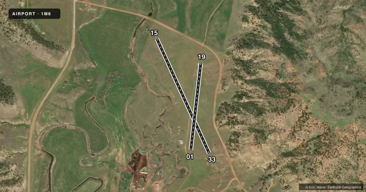
Runways & pattern
Full pagePattern entry · RWY 33
LEFT TRAFFIC| Runway | Heading (°M) | Length | Surface | Traffic |
|---|---|---|---|---|
| 15/33Favored | 155° / 335° | 2,268 ft | TURF | Standard L |
| 01/19 | 7° / 187° | 1,571 ft | TURF | Standard L |
Runway end performance
| End | TORA | TODA | ASDA | LDA | VGSI | Approach lights | Obstruction |
|---|---|---|---|---|---|---|---|
| 15 | — | — | — | — | — | — | 34', road, 145' from thr, 0' R of cntrln, slope 4 |
| 33 | — | — | — | — | — | — | 34', pline, 547' from thr, 20' R of cntrln, slope 16 |
| 01 | — | — | — | — | — | — | 24', tree, 394' from thr, 50' R of cntrln, slope 16 |
| 19 | — | — | — | — | — | — | 12', road, 341' from thr, 0' R of cntrln, slope 28 |
Declared distances in feet. TORA = takeoff run available, TODA = takeoff distance, ASDA = accelerate-stop, LDA = landing distance.
Airport sketch
Runways drawn to scale from FAA survey coordinates, rendered over satellite imagery. Not for navigation.
Approaches & charts
Services on the field
Fuel grades, oxygen, maintenance, ramp storage and lighting — as declared to the FAA by the airport operator.
Fuel & services
- Fuel
- Not available
Ramp & ground
- Transient storage
- Not published
Fuel & FBOs
Cheapest 100LL and Jet A on the field and nearby. Always confirm with the FBO before taxi.
Airport notes
Surface conditions, obstructions, local procedures, lighting outages and other notes published with each FAA cycle.
General notes
- GOPHER HOLES ALL RWYS.
- OWNER DESIRES ARPT BE CHARTED.
- RISING TRRN E OF ARPT.
- RWY 33 +343 FT HILL 4792 FT FM RWY END.
- RWY 01/19 ROAD LCTD 15 FT-75 FT W OF & PARL TO RWY, XS RWY 15/33.
- RWY 19 ROAD 302 FT FM RWY END BOTH SIDES OF CNTRLN.
- RWY 1/19 SLPS ABOUT 3 FT FM E TO W ON N HLF OF RWY.
- RWY 19 +100 FT HILL 1926 FT FM END BOTH SIDES OF CNTRLN; +369 FT HILL 3445 FT FM END 1026 FT R.
Other notes
- MANAGERCIRCLEBARRANCH@RANGEWEB.NET
VFR map & nearby airports
VFR sectional. Tap any ICAO chip to open that airport.
Key facts · 1M6
Answer card- ICAO
- 1M6
- Name
- STEVENS RANCH
- Location
- ASHLAND, MONTANA
- Elevation
- 3,300 ft MSL
- Traffic pattern altitude
- 4,300 ft MSL (1,000 AGL)
- Control tower
- Non-towered (use CTAF)
- Total runways
- 2
- Longest runway
- 15/33 · 2,268 ft
- Published ILS approaches
- 0
- Published frequencies
- 1
- Magnetic variation
- –
- Current flight rules
- VFR
- Current wind
- 300° at 6 kt
- Favored runway now
- RWY 33
Stevens Ranch is in Ashland, Montana at 3,300 ft MSL. It has two turf runways. The longest is 2,268 ft on runway 15/33. There is no control tower. CTAF is 122.9. No ILS approaches are published.
The pattern altitude is not published, so use standard 1,000 ft AGL unless the current Chart Supplement says otherwise. For light piston traffic that puts you at 4,300 ft MSL. The field sits in terrain that deserves a close look. The remarks note rising terrain east of the airport. Runway 19 also has hills near the departure path. Runway 1/19 slopes about 3 ft from east to west on the north half of the runway. There are gopher holes on all runways, so expect a rough turf surface.
There are no on-field FBOs listed. Check with the airport operator or the FBO directly by phone before arrival if you need services. The airport manager can be reached at circlebarranch@rangeweb.net. The owner wants the airport charted. That is a good reminder to verify the current Chart Supplement before you go. Plan your arrival with the runway condition, terrain and the short turf lengths in mind.