METAR & TAF KSHR
Current METAR
Observed 14:53Z
KSHR 271453Z AUTO 32007KT 10SM CLR 27/12 A2999 RMK AO2 SLP104 T02720122 53009
- Wind
- 320° @ 7 kt
- Visibility
- 10 SM
- Temp / Dew
- 27°C / 12°C
- Altimeter
- 29.99 inHg
- Clouds
- CLR
- Density alt
- 6,339 ft
- Ceiling
- Unlimited
- Rules
- VFR
Airport info & contacts
Manager on record, flight service, ARTCC, attendance schedule and pattern altitude — published by the FAA and refreshed every 28 days.
Location
- From city
- 2 NM SW
- VFR sectional
- BILLINGS
- Pattern altitude
- 800 ft AGL · 4,821 ft MSL
- ARTCC
- ZLC · SALT LAKE CITY
- NOTAM facility
- SHR (NOTAM-D)
Airport manager
- Name
- E. ROBERT GILL
- Phone
- 307-674-4222
- Address
- 908 WEST BRUNDAGE LANE, SHERIDAN WY 82801-5827
Flight service · Hours
- FSS CPR
- CASPER1-800-WX-BRIEF
- Attendance
- DALGT
Frequencies
Tap any row to copy the frequency to your clipboard.
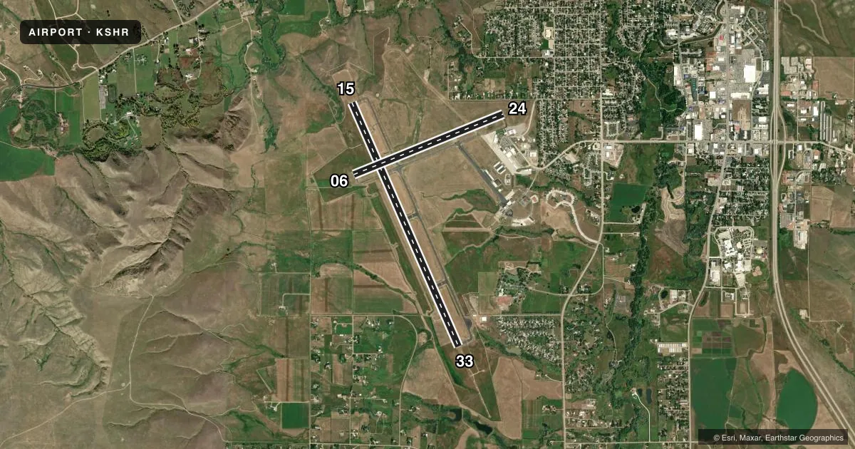
Runways & pattern
Full pagePattern entry · RWY 33
LEFT TRAFFIC| Runway | Heading (°M) | Length | Surface | Traffic |
|---|---|---|---|---|
| 15/33Favored | 146° / 326° | 8,301 ft | ASPH | Standard L |
| 06/24 | 58° / 238° | 5,039 ft | ASPH | Standard L |
Runway end performance
| End | TORA | TODA | ASDA | LDA | VGSI | Approach lights | Obstruction |
|---|---|---|---|---|---|---|---|
| 15 | 8,301' | 8,301' | 8,301' | 8,301' | PAPI 4-box left(3°) | — | — |
| 33 | 8,301' | 8,301' | 8,301' | 8,301' | PAPI 4-box left(3°) | MALSR | — |
| 06 | 5,039' | 5,039' | 5,039' | 5,039' | PAPI 4-box left(4°) | — | — |
| 24 | 5,039' | 5,039' | 5,039' | 5,039' | PAPI 4-box left(3°) | — | 40', trees, 750' from thr, 200' R of cntrln, slope 20 |
Declared distances in feet. TORA = takeoff run available, TODA = takeoff distance, ASDA = accelerate-stop, LDA = landing distance.
Airport sketch
Runways drawn to scale from FAA survey coordinates, rendered over satellite imagery. Not for navigation.
Approaches & charts
ILS · 1
Services on the field
Fuel grades, oxygen, maintenance, ramp storage and lighting — as declared to the FAA by the airport operator.
Fuel & services
- Fuel
- 100AA1+
- Oxygen (bottled)
- High pressure
- Oxygen (bulk)
- HIGH/LOW
- Airframe repair
- Major
- Power plant repair
- Major
- Other services
- AFRT,AMB,AVNCS,CARGO,CHTR,GLD,INSTR,RNTL
Ramp & ground
- Transient storage
- Tie-down
- Hangar
- Landing fee
- No fee published
- Customs
- Not available
- Lighting schedule
- SEE RMK
- Beacon schedule
- SS-SR
- Beacon
- White / Green (civil land)(WG)
- Wind indicator
- Lighted
- Segmented circle
- Yes
Fuel & FBOs
Cheapest 100LL and Jet A on the field and nearby. Always confirm with the FBO before taxi.
Airport notes
Surface conditions, obstructions, local procedures, lighting outages and other notes published with each FAA cycle.
General notes
- FW ACFT RSTRD TO RWYS & TWYS ONLY.
- COLD TEMPERATURE AIRPORT. ALTITUDE CORRECTION REQUIRED AT OR BELOW -18C.
- FOR CD IF UNA TO CTC ON FSS FREQ, CTC SALT LAKE ARTCC AT 801-320-2568.
- PILOTS CONDUCTING EFVS OPS; BE AWARE LED ALS IN USE RWY 33.
Lighting notes
- ACTVT MALSR RWY 33; REIL RWY 06, 24, & 15; PAPI RWY 06, 24, 15 & 33; HIRL RWY 15/33; MIRL RWY 06/24 - CTAF.
Runway surface & condition
- 06/24PCR VALUE: 250/F/B/X/T
- 15/33PCR VALUE: 260/F/C/X/U
Other notes
- PPR UNSKED ACFT OPS WITH MORE THAN 30 PAX SEATS CTC ARFF STN 307-673-1875.
- TPA: 800 FT AGL SNGL ENG, 1500 FT AGL TURBOPROP/JET.
- 1CONDS NOT MONITORED AT NGT AFT THE LAST ACR ARR TIL 0500L. SEE NOTAMS FOR THE MOST UP-TO-DATE CONDS AND UPDTS.
VFR map & nearby airports
VFR sectional. Tap any ICAO chip to open that airport.
Key facts · KSHR
Answer card- ICAO
- KSHR
- Name
- SHERIDAN COUNTY
- Location
- SHERIDAN, WYOMING
- Elevation
- 4,021.1 ft MSL
- Traffic pattern altitude
- 4,821.1 ft MSL (800 AGL)
- Control tower
- Non-towered (use CTAF)
- Total runways
- 2
- Longest runway
- 15/33 · 8,301 ft
- Published ILS approaches
- 1
- Published frequencies
- 2
- Magnetic variation
- 10°
- Current flight rules
- VFR
- Current wind
- 320° at 7 kt
- Favored runway now
- RWY 33
Sheridan County Airport sits in Sheridan, Wyoming. The field elevation is 4,021.1 ft MSL. It has two asphalt runways. The longest is runway 15/33 at 8,301 ft. There is no control tower. CTAF and UNICOM are both 123.0. One ILS approach is published for runway 33. Pattern altitude is 800 ft AGL for single-engine aircraft. That is 4,821.1 ft MSL. Turboprops and jets use 1,500 ft AGL.
Sheridan Pilots 307 and Bighorn Airways are on the field. Sheridan Pilots 307 carries 100LL. Bighorn Airways carries 100LL and Jet A with Prist. If you need current ramp or fuel details, call the FBO directly before you launch.
A few items matter here. This is a cold temperature airport, so altitude correction is required at or below minus 18 degrees Celsius. Conditions are not monitored at night after the last aircraft arrival until 0500 local time. Runway 33 has medium intensity approach lighting with runway alignment indicator lights. Runways 06, 24, 15 and 33 also have PAPI. Fixed-wing aircraft are restricted to runways and taxiways only. If you are planning an unscheduled aircraft operation with more than 30 passenger seats, prior permission is required. Check the current FAA Chart Supplement for any current noise or curfew restrictions before flying in.