METAR & TAF U68
Current METAR
Observed 12:15Z
KU68 271215Z AUTO 05004KT 10SM CLR 21/10 A2999 RMK AO2
- Wind
- 050° @ 4 kt
- Visibility
- 10 SM
- Temp / Dew
- 21°C / 10°C
- Altimeter
- 29.99 inHg
- Clouds
- CLR
- Density alt
- 5,709 ft
- Ceiling
- Unlimited
- Rules
- VFR
Airport info & contacts
Manager on record, flight service, ARTCC, attendance schedule and pattern altitude — published by the FAA and refreshed every 28 days.
Location
- From city
- 2 NM N
- VFR sectional
- BILLINGS
- ARTCC
- ZLC · SALT LAKE CITY
- NOTAM facility
- CPR (NOTAM-D)
Airport manager
- Name
- PAUL THUR
- Phone
- 307-337-8159
- Address
- P. O. BOX 29, PO BOX 31, BASIN WY 82410
Flight service · Hours
- FSS CPR
- CASPER1-800-WX-BRIEF
- Attendance
- IRREG
Frequencies
Tap any row to copy the frequency to your clipboard.
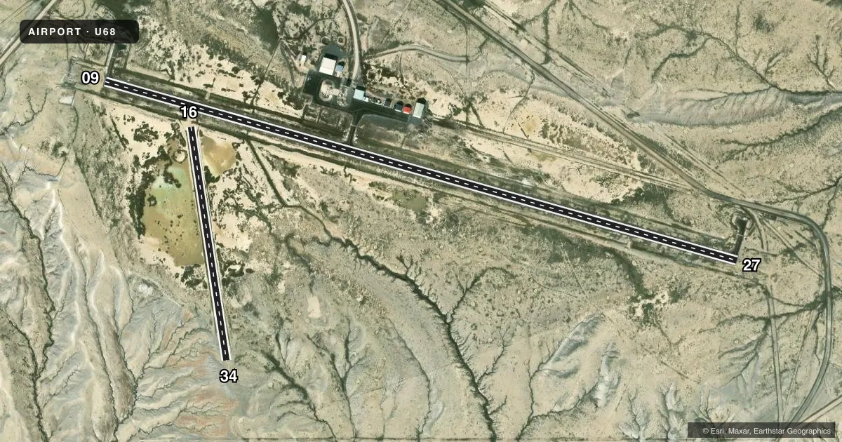
Runways & pattern
Full pagePattern entry · RWY 09
LEFT TRAFFIC| Runway | Heading (°M) | Length | Surface | Traffic |
|---|---|---|---|---|
| 09/27Favored | 95° / 275° | 5,200 ft | ASPH | Standard L |
| 16/34 | 161° / 341° | 1,866 ft | DIRT | Standard L |
Runway end performance
| End | TORA | TODA | ASDA | LDA | VGSI | Approach lights | Obstruction |
|---|---|---|---|---|---|---|---|
| 09 | — | — | — | — | PAPI 2-box left(3°) | — | 8', hill, 315' from thr, 90' R of cntrln, slope 14 |
| 27 | — | — | — | — | PAPI 2-box left(3°) | — | 91', hill, 3673' from thr, 40' R of cntrln, slope 38 |
Declared distances in feet. TORA = takeoff run available, TODA = takeoff distance, ASDA = accelerate-stop, LDA = landing distance.
Airport sketch
Runways drawn to scale from FAA survey coordinates, rendered over satellite imagery. Not for navigation.
Approaches & charts
Services on the field
Fuel grades, oxygen, maintenance, ramp storage and lighting — as declared to the FAA by the airport operator.
Fuel & services
- Fuel
- 100LL
- Oxygen (bottled)
- Not available
- Oxygen (bulk)
- Not available
- Airframe repair
- Not available
- Power plant repair
- Not available
Ramp & ground
- Transient storage
- Tie-down
- Landing fee
- No fee published
- Customs
- Not available
- Lighting schedule
- SEE RMK
- Beacon schedule
- SS-SR
- Beacon
- White / Green (civil land)(WG)
- Wind indicator
- Lighted
- Segmented circle
- Yes
Fuel & FBOs
Cheapest 100LL and Jet A on the field and nearby. Always confirm with the FBO before taxi.
Airport notes
Surface conditions, obstructions, local procedures, lighting outages and other notes published with each FAA cycle.
General notes
- RWY 16/34 SOFT WHEN WET.
- REFLECTIVE MKRS MARK ENTRANCE TO TWY & TURNAROUND.
- FOR CD CTC SALT LAKE ARTCC AT 801-320-2568.
Lighting notes
- ACTVT MIRL RWY 09/27; PAPI RWY 09 & 27; REIL RWY 9 & 27- CTAF.
Fuel notes
- 100LLSVC AVBL H24 VIA CREDIT CARD.
Approach & departure obstructions
- 1616/34 RWY END DELINATED BY +1 FT CONES.
Other notes
- 2 MILES N OF COWLEY.
- PILOT SUPPLIED ROPES PREFERRED FOR TIE DOWNS.
- 2ATNDNC IS PERIODIC & UNSKED. FONE AHD FOR SVCS. FOR ATTENDANT AFT HRS CALL 307-250-7215 OR TEXT/CALL AMGR.
VFR map & nearby airports
VFR sectional. Tap any ICAO chip to open that airport.
Key facts · U68
Answer card- ICAO
- U68
- Name
- NORTH BIG HORN COUNTY
- Location
- COWLEY/LOVELL/BYRON, WYOMING
- Elevation
- 4,093.5 ft MSL
- Traffic pattern altitude
- 5,093.5 ft MSL (1,000 AGL)
- Control tower
- Non-towered (use CTAF)
- Total runways
- 2
- Longest runway
- 09/27 · 5,200 ft
- Published ILS approaches
- 0
- Published frequencies
- 2
- Magnetic variation
- 11°
- Current flight rules
- VFR
- Current wind
- 050° at 4 kt
- Favored runway now
- RWY 09
North Big Horn County Airport (U68) sits 2 miles north of Cowley in northwestern Wyoming. Field elevation is 4,093.5 ft MSL. The airport has 2 runways. The longest is 09/27 at 5,200 ft asphalt. Runway 16/34 is 1,866 ft dirt. There is no control tower. CTAF and UNICOM are both 123.0. No ILS approaches are published, so plan with the current chart and your own crosswind limits in mind.
Pattern altitude is not published. Use 1,000 ft AGL for light piston operations unless the current FAA Chart Supplement says otherwise. The on-field FBO is North Big Horn County Airport. It carries 100LL. Fuel service is available 24 hours via credit card. Attendance is periodic and unscheduled, so call ahead if you need help on arrival. The published remarks also note that runway 16/34 can be soft when wet. That matters here. The dirt strip and the higher field elevation can both affect performance. Runway 09 and 27 have medium intensity lights, PAPI and REILs. The REILs are activated by CTAF. For clearance delivery, contact Salt Lake ARTCC before departure.