METAR & TAF KPOY
Current METAR
Observed 12:50Z
KPOY 271250Z AUTO 28010KT SCT120 20/08 A3010 RMK AO2 LTG DSNT SW PWINO
- Wind
- 280° @ 10 kt
- Visibility
- —
- Temp / Dew
- 20°C / 8°C
- Altimeter
- 30.10 inHg
- Clouds
- SCT
- Density alt
- 6,696 ft
- Ceiling
- Unlimited
- Rules
- VFR
Airport info & contacts
Manager on record, flight service, ARTCC, attendance schedule and pattern altitude — published by the FAA and refreshed every 28 days.
Location
- From city
- 7 NM N
- VFR sectional
- BILLINGS
- ARTCC
- ZLC · SALT LAKE CITY
- NOTAM facility
- CPR (NOTAM-D)
Airport manager
- Name
- BEN HUBBARD
- Phone
- 307-754-5234
- Address
- 270 NORTH CLARK, POWELL WY 82435
Flight service · Hours
- FSS CPR
- CASPER1-800-WX-BRIEF
- Attendance
- MON-FRI · 0700-1630
Frequencies
Tap any row to copy the frequency to your clipboard.
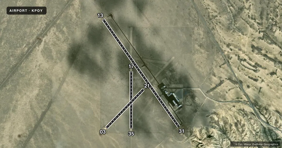
Runways & pattern
Full pagePattern entry · RWY 31
LEFT TRAFFIC| Runway | Heading (°M) | Length | Surface | Traffic |
|---|---|---|---|---|
| 13/31Favored | 134° / 314° | 6,200 ft | ASPH | Standard L |
| 17/35 | 169° / 349° | 2,698 ft | TURF-DIRT | Standard L |
| 03/21 | 33° / 213° | 2,529 ft | TURF-DIRT | Standard L |
Runway end performance
| End | TORA | TODA | ASDA | LDA | VGSI | Approach lights | Obstruction |
|---|---|---|---|---|---|---|---|
| 13 | — | — | — | — | PAPI 2-box left(3°) | — | — |
| 31 | — | — | — | — | PAPI 2-box left(3°) | — | 25', fence, 1150' from thr, 0' R of cntrln, slope 38 |
| 35 | — | — | — | — | — | — | 10', fence, 233' from thr, slope 23 |
| 03 | — | — | — | — | — | — | 12', fence, 252' from thr, 21' R of cntrln, slope 21 |
Declared distances in feet. TORA = takeoff run available, TODA = takeoff distance, ASDA = accelerate-stop, LDA = landing distance.
Airport sketch
Runways drawn to scale from FAA survey coordinates, rendered over satellite imagery. Not for navigation.
Approaches & charts
Services on the field
Fuel grades, oxygen, maintenance, ramp storage and lighting — as declared to the FAA by the airport operator.
Fuel & services
- Fuel
- 100LLA
- Oxygen (bottled)
- Not available
- Oxygen (bulk)
- Not available
- Airframe repair
- Not available
- Power plant repair
- Not available
- Other services
- AGRI
Ramp & ground
- Transient storage
- Tie-down
- Hangar
- Landing fee
- No fee published
- Customs
- Not available
- Lighting schedule
- SEE RMK
- Beacon schedule
- SS-SR
- Beacon
- White / Green (civil land)(WG)
- Wind indicator
- Lighted
- Segmented circle
- Yes
Fuel & FBOs
Cheapest 100LL and Jet A on the field and nearby. Always confirm with the FBO before taxi.
Airport notes
Surface conditions, obstructions, local procedures, lighting outages and other notes published with each FAA cycle.
General notes
- AFT HRS EMERG CTC POLICE DISPATCH 307-754-2212 OR THE SHERIFFS OFC 307-754-8700.
Lighting notes
- ACTVT REIL RWY 31; PAPI RWY 13 & 31; MIRL RWY 13/31 - CTAF.
Fuel notes
- 100LLFUEL H24 HR VIA CREDIT CARD.
Other notes
- PILOT SUPD ROPES RQRD.
- MANAGERADNL CTC BEN HUBBARD 307-754-6922.
- MANAGERCELL 307-254-0256.
VFR map & nearby airports
VFR sectional. Tap any ICAO chip to open that airport.
Key facts · KPOY
Answer card- ICAO
- KPOY
- Name
- POWELL MUNI
- Location
- POWELL, WYOMING
- Elevation
- 5,096.1 ft MSL
- Traffic pattern altitude
- 6,096.1 ft MSL (1,000 AGL)
- Control tower
- Non-towered (use CTAF)
- Total runways
- 3
- Longest runway
- 13/31 · 6,200 ft
- Published ILS approaches
- 0
- Published frequencies
- 2
- Magnetic variation
- 11°
- Current flight rules
- VFR
- Current wind
- 280° at 10 kt
- Favored runway now
- RWY 31
Powell Muni is in Powell, Wyoming. The field elevation is 5,096.1 ft MSL. It has three runways. The longest is runway 13/31 at 6,200 ft asphalt. There is no control tower. CTAF and UNICOM are both 122.7.
No ILS approaches are published here. The pattern altitude is not published, so use standard 1,000 ft AGL for light piston operations unless the current Chart Supplement says otherwise. That puts the traffic pattern at about 6,096 ft MSL based on the field elevation. Runway lighting is available on 13 and 31. Those runways also have PAPI. Runway 31 has runway end identifier lights. The lighting is controlled on the common traffic advisory frequency.
Powell Municipal Airport is the on-field FBO. It carries 100LL and Jet A. Fuel is available 24 hours by credit card. Pilot supplied ropes are required for tie-down. If you need after-hours help, the published remarks list police dispatch and the sheriff's office for emergencies. This is a high-elevation field, so performance planning matters. Expect the usual Wyoming density altitude effect on warm days. Check the current FAA Chart Supplement for any updates before departure.