METAR & TAF 6V5
6V5 does not publish a METAR.
Showing the nearest reporting station: KHEI (HETTINGER/JB LINDQUIST RGNL) · 30.8 NM away. Conditions at 6V5 may differ.
METAR · KHEI
Observed 16:53Z
KHEI 271653Z AUTO 11011G17KT 10SM CLR 33/10 A2995 RMK AO2 SLP116 T03280100
- Wind
- 110° @ 11G17 kt
- Visibility
- 10 SM
- Temp / Dew
- 33°C / 10°C
- Altimeter
- 29.95 inHg
- Clouds
- CLR
- Density alt
- 5,584 ft
- Ceiling
- Unlimited
- Rules
- VFR
Airport info & contacts
Manager on record, flight service, ARTCC, attendance schedule and pattern altitude — published by the FAA and refreshed every 28 days.
Location
- From city
- 0 NM SW
- VFR sectional
- BILLINGS
- ARTCC
- ZMP · MINNEAPOLIS
- NOTAM facility
- HON (NOTAM-D)
Airport manager
- Name
- CITY OF BISON
- Phone
- 605-244-5677
- Address
- PO BOX 910, BISON SD 57620
Flight service · Hours
- FSS HON
- HURON1-800-WX-BRIEF
- Attendance
- Unattended
Frequencies
Tap any row to copy the frequency to your clipboard.
Runways & pattern
Full pagePattern entry · RWY 11
LEFT TRAFFICRunway end performance
| End | TORA | TODA | ASDA | LDA | VGSI | Approach lights | Obstruction |
|---|---|---|---|---|---|---|---|
| 11 | — | — | — | — | PAPI 2-box left(3°) | — | — |
| 29 | — | — | — | — | PAPI 2-box left(3°) | — | 28', trees, 574' from thr, 136' R of cntrln, slope 13 |
Declared distances in feet. TORA = takeoff run available, TODA = takeoff distance, ASDA = accelerate-stop, LDA = landing distance.
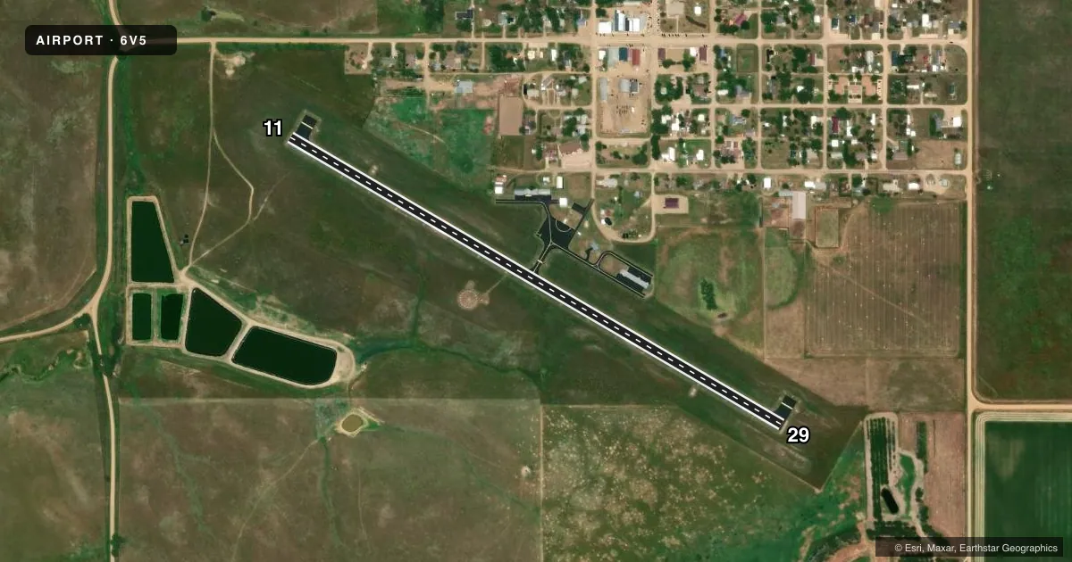
Airport sketch
Runways drawn to scale from FAA survey coordinates, rendered over satellite imagery. Not for navigation.
Approaches & charts
Services on the field
Fuel grades, oxygen, maintenance, ramp storage and lighting — as declared to the FAA by the airport operator.
Fuel & services
- Fuel
- 100LL
- Oxygen (bottled)
- Not available
- Oxygen (bulk)
- Not available
- Airframe repair
- Not available
- Power plant repair
- Not available
- Other services
- AGRI,INSTR
Ramp & ground
- Transient storage
- Tie-down
- Hangar
- Landing fee
- No fee published
- Customs
- Not available
- Lighting schedule
- SEE RMK
- Beacon schedule
- SS-SR
- Beacon
- White / Green (civil land)(WG)
- Wind indicator
- Lighted
- Segmented circle
- Yes
Fuel & FBOs
Cheapest 100LL and Jet A on the field and nearby. Always confirm with the FBO before taxi.
Airport notes
Surface conditions, obstructions, local procedures, lighting outages and other notes published with each FAA cycle.
General notes
- WILDLIFE ON AND INVOF ARPT.
- FOR CD CTC MINNEAPOLIS ARTCC AT 651-463-5588.
Lighting notes
- ACTVT MIRL RWY 11/29 - CTAF.
Fuel notes
- 100LLFUEL AVBL H24 VIA CREDIT CARD.
VFR map & nearby airports
VFR sectional. Tap any ICAO chip to open that airport.
Key facts · 6V5
Answer card- ICAO
- 6V5
- Name
- BISON MUNI
- Location
- BISON, SOUTH DAKOTA
- Elevation
- 2,791 ft MSL
- Traffic pattern altitude
- 3,791 ft MSL (1,000 AGL)
- Control tower
- Non-towered (use CTAF)
- Total runways
- 1
- Longest runway
- 11/29 · 3,500 ft
- Published ILS approaches
- 0
- Published frequencies
- 1
- Magnetic variation
- 11°
- Current flight rules
- VFR
- Current wind
- 110° at 11 kt
- Favored runway now
- RWY 11
Bison Muni is in Bison, South Dakota. The field elevation is 2,791 ft MSL. It has one runway. The longest is runway 11/29 at 3,500 ft on asphalt. There is no control tower, so plan to use CTAF 122.9 for local traffic calls. No ILS approaches are published for the field.
The pattern altitude is not published. Use the standard 1,000 ft AGL pattern unless the current Chart Supplement or local procedures say otherwise. The on-field FBO is Bison Municipal Airport. It carries 100LL and has 24-hour self-serve fuel by credit card. Medium intensity runway lights on 11/29 are activated by CTAF, so make sure you know the lighting procedure before a night arrival.
A first-time pilot should also plan for wildlife in and around the airport. That matters here. The airport is not towered, so clearance delivery goes through Minneapolis ARTCC at 651-463-5588. With a single 3,500 ft runway and no published ILS, this is a straightforward VFR field. Check wind, density altitude and runway condition before you go.