METAR & TAF Y71
Y71 does not publish a METAR.
Showing the nearest reporting station: KHEI (HETTINGER/JB LINDQUIST RGNL) · 40.3 NM away. Conditions at Y71 may differ.
METAR · KHEI
Observed 11:53Z
KHEI 271153Z AUTO 00000KT 5SM HZ CLR 15/09 A2995 RMK AO2 SLP116 T01500089 10211 20144 58002
- Wind
- 000° @ 0 kt
- Visibility
- 5 SM
- Temp / Dew
- 15°C / 9°C
- Altimeter
- 29.95 inHg
- Clouds
- CLR
- Density alt
- 2,883 ft
- Ceiling
- Unlimited
- Rules
- MVFR
Airport info & contacts
Manager on record, flight service, ARTCC, attendance schedule and pattern altitude — published by the FAA and refreshed every 28 days.
Location
- From city
- 1 NM S
- VFR sectional
- BILLINGS
- ARTCC
- ZMP · MINNEAPOLIS
- NOTAM facility
- GFK (NOTAM-D)
Airport manager
- Name
- AARON LEVORSEN
- Phone
- 701-220-3442
- Address
- 7125 67TH AVE SW, ELGIN ND 58533
Flight service · Hours
- FSS GFK
- GRAND FORKS1-800-WX-BRIEF
- Attendance
- Unattended
Frequencies
Tap any row to copy the frequency to your clipboard.
Runways & pattern
Full pagePattern entry · RWY 12
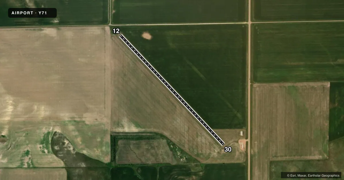
LEFT TRAFFICAirport sketch
Runways drawn to scale from FAA survey coordinates, rendered over satellite imagery. Not for navigation.
Approaches & charts
Services on the field
Fuel grades, oxygen, maintenance, ramp storage and lighting — as declared to the FAA by the airport operator.
Fuel & services
- Fuel
- Not available
- Oxygen (bottled)
- Not available
- Oxygen (bulk)
- Not available
- Airframe repair
- Not available
- Power plant repair
- Not available
Ramp & ground
- Transient storage
- Tie-down
- Landing fee
- No fee published
- Wind indicator
- Yes
- Segmented circle
- No
Fuel & FBOs
Cheapest 100LL and Jet A on the field and nearby. Always confirm with the FBO before taxi.
Airport notes
Surface conditions, obstructions, local procedures, lighting outages and other notes published with each FAA cycle.
General notes
- CONFIRM SNOW REMOVAL; ON REQUEST ONLY IN WINTER MOS WITH AMGR BEFORE USE 701-584-3442.
- NO LINE-OF-SIGHT BTN RWYS 12 & 30 BGNG 500'FM RWY 12 END & 1000'FM RWY 30 END TO A HGT OF 20' MID-CNTR.
- RWY 30; 10 FT DROPOFF 100 FT FROM THR OUTBOUND.
- FOR CD CTC MINNEAPOLIS ARTCC AT 651-463-5588.
Other notes
- NO TIE DOWN ROPES AVBL.
- MANAGERCHAIRMAN OF ARPT AUTH HOME PHONE 701-584-3442.
- 12/30RWY SFC CLUMPY & ROUGH. DIRT MOUNDS PRSNT.
VFR map & nearby airports
VFR sectional. Tap any ICAO chip to open that airport.
Key facts · Y71
Answer card- ICAO
- Y71
- Name
- ELGIN MUNI
- Location
- ELGIN, NORTH DAKOTA
- Elevation
- 2,355 ft MSL
- Traffic pattern altitude
- 3,355 ft MSL (1,000 AGL)
- Control tower
- Non-towered (use CTAF)
- Total runways
- 1
- Longest runway
- 12/30 · 2,842 ft
- Published ILS approaches
- 0
- Published frequencies
- 1
- Magnetic variation
- 10°
- Current flight rules
- MVFR
- Current wind
- 000° at 0 kt
- Favored runway now
- –
ELGIN MUNI sits in Elgin, North Dakota. Field elevation is 2,355 ft MSL. The airport has one runway. Runway 12/30 is 2,842 ft of turf, so plan for soft-field performance and a careful surface check before landing. The field is not towered. CTAF is 122.9.
No ILS approaches are published here. Pattern altitude is not published in the facts, so use the current FAA Chart Supplement before you go. The published remarks matter here. Runway 12/30 is described as clumpy and rough with dirt mounds present. Runway 30 also has a 10 ft dropoff 100 ft beyond the threshold. There is no line of sight between the runway ends in the center section at low height, so keep that in mind when taxiing and when you are checking for traffic.
There are no on-field FBOs listed. If you need services, call the airport operator or the field directly before arrival. Snow removal is by request only in winter months. The airport authority chairman’s home phone is listed in the Chart Supplement remarks. For clearance delivery, contact Minneapolis ARTCC. This is a non-towered turf strip at moderate elevation, so expect density altitude to matter on warm days.