METAR & TAF KHEI
Current METAR
Observed 15:53Z
KHEI 271553Z AUTO 11010KT 10SM CLR 30/10 A2996 RMK AO2 SLP118 T03000100
- Wind
- 110° @ 10 kt
- Visibility
- 10 SM
- Temp / Dew
- 30°C / 10°C
- Altimeter
- 29.96 inHg
- Clouds
- CLR
- Density alt
- 5,106 ft
- Ceiling
- Unlimited
- Rules
- VFR
Airport info & contacts
Manager on record, flight service, ARTCC, attendance schedule and pattern altitude — published by the FAA and refreshed every 28 days.
Location
- From city
- 1 NM NW
- VFR sectional
- BILLINGS
- ARTCC
- ZMP · MINNEAPOLIS
- NOTAM facility
- HEI (NOTAM-D)
Airport manager
- Name
- JAY B. LINDQUIST
- Phone
- 701-567-2069
- Address
- PO BOX 429, HETTINGER ND 58639
Flight service · Hours
- FSS GFK
- GRAND FORKS1-800-WX-BRIEF
- Attendance
- MON-SAT · 0700-1700
Frequencies
Tap any row to copy the frequency to your clipboard.
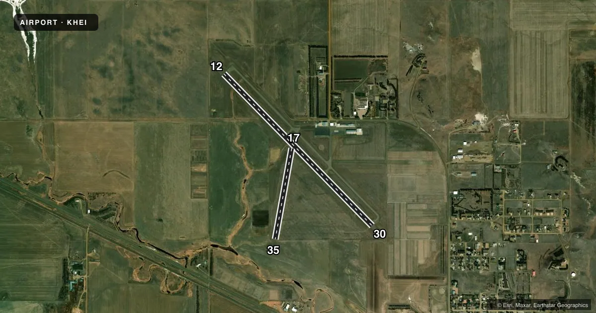
Runways & pattern
Full pagePattern entry · RWY 12
LEFT TRAFFIC| Runway | Heading (°M) | Length | Surface | Traffic |
|---|---|---|---|---|
| 12/30Favored | 128° / 308° | 4,652 ft | ASPH | Standard L |
| 17/35 | 182° / 2° | 2,020 ft | TURF | Standard L |
Runway end performance
| End | TORA | TODA | ASDA | LDA | VGSI | Approach lights | Obstruction |
|---|---|---|---|---|---|---|---|
| 12 | — | — | — | — | PAPI 2-box left(3°) | — | — |
| 30 | — | — | — | — | PAPI 2-box left(3°) | — | — |
Declared distances in feet. TORA = takeoff run available, TODA = takeoff distance, ASDA = accelerate-stop, LDA = landing distance.
Airport sketch
Runways drawn to scale from FAA survey coordinates, rendered over satellite imagery. Not for navigation.
Approaches & charts
Services on the field
Fuel grades, oxygen, maintenance, ramp storage and lighting — as declared to the FAA by the airport operator.
Fuel & services
- Fuel
- 100LLA
- Oxygen (bottled)
- Not available
- Oxygen (bulk)
- Not available
- Airframe repair
- Major
- Power plant repair
- Major
- Other services
- AGRI,INSTR,RNTL,SALES
Ramp & ground
- Transient storage
- Tie-down
- Hangar
- Landing fee
- No fee published
- Customs
- Not available
- Lighting schedule
- SEE RMK
- Beacon schedule
- SS-SR
- Beacon
- White / Green (civil land)(WG)
- Wind indicator
- Lighted
- Segmented circle
- Yes
Fuel & FBOs
Cheapest 100LL and Jet A on the field and nearby. Always confirm with the FBO before taxi.
Airport notes
Surface conditions, obstructions, local procedures, lighting outages and other notes published with each FAA cycle.
General notes
- CFM WINTER COND RWY 17/35 CALL AMGR 701-567-2069/4469 OR 701-928-0615.
- TWYS ILLUMINATED WITH REFLECTORS FOR NIGHTIME USE.
- DEER ON & INVOF ARPT.
- FOR CD CTC MINNEAPOLIS ARTCC AT 651-463-5588.
- WIND TURBINES LCTD APRXLY 13000 FT NE OF ARPT.
Lighting notes
- PAPI RWY 12 & 30; MIRL RWY 12/30 OPR CONSLY FM DUSK TO 2200; AFT 2200 TO ACTVT PAPI RWY 12 & 30; MIRL RWY 12/30 - CTAF.
Fuel notes
- 100LL24-HR SELF- SERVICE FUEL AVBL WITH CREDIT CARD.
Other notes
- AIRSPACE 73-RM-68-NRA.
- WINDSOCKS LOCATED EACH END OF RWY 12/30.
- 1FOR ATTENDANT DUSK-DAWN CALL (701) 928-0615.
- MANAGERADDL CTC AFT HRS CHARLES LINDQUIST 701-567-4469 OR 701-928-0615.
VFR map & nearby airports
VFR sectional. Tap any ICAO chip to open that airport.
Key facts · KHEI
Answer card- ICAO
- KHEI
- Name
- HETTINGER/JB LINDQUIST RGNL
- Location
- HETTINGER, NORTH DAKOTA
- Elevation
- 2,705.8 ft MSL
- Traffic pattern altitude
- 3,705.8 ft MSL (1,000 AGL)
- Control tower
- Non-towered (use CTAF)
- Total runways
- 2
- Longest runway
- 12/30 · 4,652 ft
- Published ILS approaches
- 0
- Published frequencies
- 2
- Magnetic variation
- 8°
- Current flight rules
- VFR
- Current wind
- 110° at 10 kt
- Favored runway now
- RWY 12
Hettinger/JB Lindquist Rgnl sits in Hettinger, North Dakota at 2,705.8 ft MSL. The field has two runways. The longest is 12/30 at 4,652 ft. Runway 17/35 is turf at 2,020 ft. There is no control tower, so plan to self-announce on CTAF 122.8. No ILS approaches are published here.
Pattern altitude is not published. Use the standard 1,000 ft AGL for light piston operations unless local guidance says otherwise. Air Dakota Flite is on the field. It carries 100LL and Jet A Prist. 24-hour self-service 100LL is available with a credit card. For after-hours help, the published remarks list Charles Lindquist as an additional contact. The field also has PAPI on runways 12 and 30. Medium intensity runway lights on 12/30 run continuously from dusk to 2200. After 2200, use CTAF to activate the PAPI and runway lights.
A first-time pilot should pay attention to the deer reported on and near the airport. Winter conditions can affect runway 17/35, so call ahead if you plan to use the turf strip. Windsocks are at each end of 12/30. Taxiways use reflectors at night. The published remarks also note nearby wind turbines about 13,000 ft northeast of the airport.