METAR & TAF D07
Current METAR
Observed 04:56Z
KD07 270456Z AUTO 08008KT 27/07 A2990 RMK AO1 SLP098 T02720067
- Wind
- 080° @ 8 kt
- Visibility
- —
- Temp / Dew
- 27°C / 7°C
- Altimeter
- 29.90 inHg
- Clouds
- Clear
- Density alt
- 4,669 ft
- Ceiling
- Unlimited
- Rules
- VFR
Airport info & contacts
Manager on record, flight service, ARTCC, attendance schedule and pattern altitude — published by the FAA and refreshed every 28 days.
Location
- From city
- 1 NM E
- VFR sectional
- BILLINGS
- ARTCC
- ZMP · MINNEAPOLIS
- NOTAM facility
- HON (NOTAM-D)
Airport manager
- Name
- CITY OF FAITH
- Phone
- 605-967-2261
- Address
- PO BOX 494, FAITH SD 57626
Flight service · Hours
- FSS HON
- HURON1-800-WX-BRIEF
- Attendance
- Unattended
Frequencies
Tap any row to copy the frequency to your clipboard.
Runways & pattern
Full pagePattern entry · RWY 13
LEFT TRAFFICRunway end performance
| End | TORA | TODA | ASDA | LDA | VGSI | Approach lights | Obstruction |
|---|---|---|---|---|---|---|---|
| 13 | — | — | — | — | PAPI 2-box left(3°) | — | — |
| 31 | — | — | — | — | PAPI 2-box left(3°) | — | 22', road, 713' from thr, 0' R of cntrln, slope 23 |
Declared distances in feet. TORA = takeoff run available, TODA = takeoff distance, ASDA = accelerate-stop, LDA = landing distance.
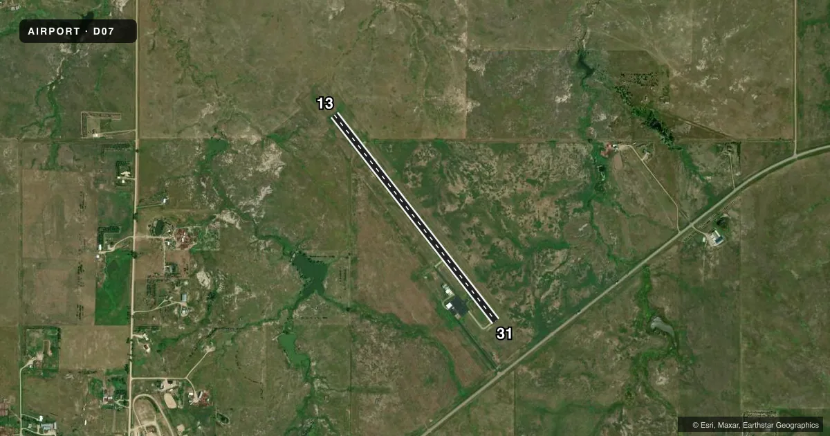
Airport sketch
Runways drawn to scale from FAA survey coordinates, rendered over satellite imagery. Not for navigation.
Approaches & charts
Services on the field
Fuel grades, oxygen, maintenance, ramp storage and lighting — as declared to the FAA by the airport operator.
Fuel & services
- Fuel
- 100LL
- Airframe repair
- Not available
- Power plant repair
- Not available
- Other services
- AGRI
Ramp & ground
- Transient storage
- Tie-down
- Hangar
- Landing fee
- No fee published
- Lighting schedule
- SEE RMK
- Beacon schedule
- SS-SR
- Beacon
- White / Green (civil land)(WG)
- Wind indicator
- Lighted
- Segmented circle
- Yes
Fuel & FBOs
Cheapest 100LL and Jet A on the field and nearby. Always confirm with the FBO before taxi.
Airport notes
Surface conditions, obstructions, local procedures, lighting outages and other notes published with each FAA cycle.
General notes
- WILDLIFE ON & INVOF ARPT.
- FOR CD CTC MINNEAPOLIS ARTCC AT 651-463-5588.
Lighting notes
- ACTVT PAPI RWY 13 & 31; MIRL RWY 13/31 - CTAF.
Fuel notes
- 100LLFUEL AVAILABLE WITH 24 HOURS WITH CREDIT CARD.
VFR map & nearby airports
VFR sectional. Tap any ICAO chip to open that airport.
Key facts · D07
Answer card- ICAO
- D07
- Name
- FAITH MUNI
- Location
- FAITH, SOUTH DAKOTA
- Elevation
- 2,584.3 ft MSL
- Traffic pattern altitude
- 3,584.3 ft MSL (1,000 AGL)
- Control tower
- Non-towered (use CTAF)
- Total runways
- 1
- Longest runway
- 13/31 · 4,191 ft
- Published ILS approaches
- 0
- Published frequencies
- 2
- Magnetic variation
- 11°
- Current flight rules
- VFR
- Current wind
- 080° at 8 kt
- Favored runway now
- RWY 13
Faith Muni is in Faith, South Dakota. The field elevation is 2,584.3 ft MSL. It has one runway. Runway 13/31 is 4,191 ft long and asphalt. There is no control tower. CTAF and UNICOM are both 122.8. No ILS approaches are published.
The pattern altitude is not published. Use the standard 1,000 ft AGL pattern unless the current Chart Supplement says otherwise. The on-field FBO is Faith Municipal Airport. It carries 100LL. Fuel is available within 24 hours with a credit card. The runway lighting on 13 and 31 is medium intensity and controlled on CTAF. A precision approach path indicator is also available for both runway ends.
First-time pilots should plan for wildlife in and near the airport. That matters here. The field sits at 2,584.3 ft MSL, so density altitude can build quickly on warm days. Check performance before departure. For clearance delivery, contact Minneapolis ARTCC at 651-463-5588. If you need current operational details, verify them with the current FAA Chart Supplement or call the airport operator directly.