METAR & TAF 4D9
4D9 does not publish a METAR.
Showing the nearest reporting station: KHDE (BREWSTER FLD) · 20.4 NM away. Conditions at 4D9 may differ.
METAR · KHDE
Observed 04:55Z
KHDE 270455Z AUTO 18006KT 10SM CLR 28/23 A2982 RMK AO2 T02750225
- Wind
- 180° @ 6 kt
- Visibility
- 10 SM
- Temp / Dew
- 28°C / 23°C
- Altimeter
- 29.82 inHg
- Clouds
- CLR
- Density alt
- 4,254 ft
- Ceiling
- Unlimited
- Rules
- VFR
Airport info & contacts
Manager on record, flight service, ARTCC, attendance schedule and pattern altitude — published by the FAA and refreshed every 28 days.
Location
- From city
- 1 NM NE
- VFR sectional
- OMAHA
- ARTCC
- ZDV · DENVER
- NOTAM facility
- OLU (NOTAM-D)
Airport manager
- Name
- RON HAWLEY
- Phone
- 308-470-0563
- Address
- 12359 707 ROAD, PO BOX 468, NAPONEE NE 68910-9608
Flight service · Hours
- FSS OLU
- COLUMBUS1-800-WX-BRIEF
- Attendance
- Unattended
Frequencies
Tap any row to copy the frequency to your clipboard.
Runways & pattern
Full pagePattern entry · RWY 17
LEFT TRAFFICRunway end performance
| End | TORA | TODA | ASDA | LDA | VGSI | Approach lights | Obstruction |
|---|---|---|---|---|---|---|---|
| 17 | — | — | — | — | PAPI 2-box left(3°) | — | — |
| 35 | — | — | — | — | PAPI 2-box left(3°) | — | — |
Declared distances in feet. TORA = takeoff run available, TODA = takeoff distance, ASDA = accelerate-stop, LDA = landing distance.
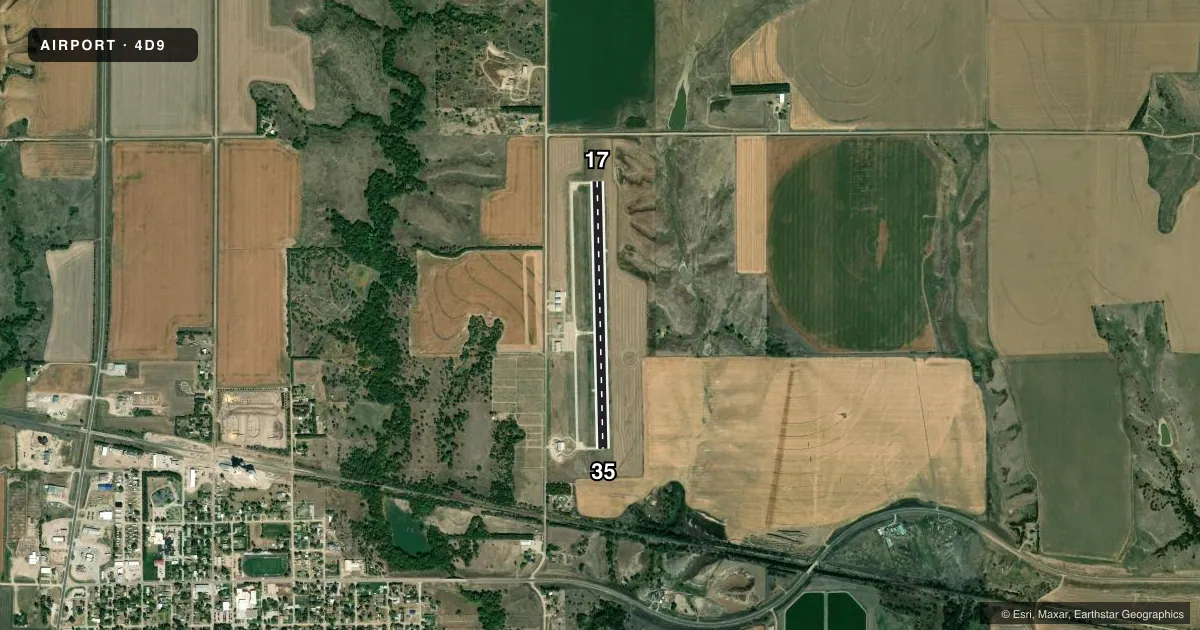
Airport sketch
Runways drawn to scale from FAA survey coordinates, rendered over satellite imagery. Not for navigation.
Approaches & charts
Services on the field
Fuel grades, oxygen, maintenance, ramp storage and lighting — as declared to the FAA by the airport operator.
Fuel & services
- Fuel
- 100LL
- Oxygen (bottled)
- Not available
- Oxygen (bulk)
- Not available
- Airframe repair
- Not available
- Power plant repair
- Not available
- Other services
- AGRI,INSTR
Ramp & ground
- Transient storage
- Tie-down
- Lighting schedule
- SEE RMK
- Beacon schedule
- SS-SR
- Beacon
- White / Green (civil land)(WG)
- Wind indicator
- Lighted
- Segmented circle
- Yes
Fuel & FBOs
Cheapest 100LL and Jet A on the field and nearby. Always confirm with the FBO before taxi.
Airport notes
Surface conditions, obstructions, local procedures, lighting outages and other notes published with each FAA cycle.
General notes
- UNMARKED, UNLIGHTED TOWER 6NM NW OF ARPT @ 2458 MSL.
- SEGMENTED CIRCLE CONCRETE IN GRND.
- FOR CD CTC DENVER ARTCC AT 303-651-4257.
Lighting notes
- ACTVT MIRL RY 17/35 & PAPI RY 17/35 - CTAF.
Fuel notes
- 100LLSELF SVC FUEL AVBL 24 HRS VIA CREDIT CARD SYSTEM.
Other notes
- PROVIDED CLEAR APCH TO EACH RY END FOR MIN 20:1 GLIDE SLOPE; CLEAR TRANSITIONAL SFC FOR 7:1 SLOPE; OLD ALMA MUNI TO CLOSE CONCURRENTLY WITH COMMISSIONING.
VFR map & nearby airports
VFR sectional. Tap any ICAO chip to open that airport.
Key facts · 4D9
Answer card- ICAO
- 4D9
- Name
- ALMA MUNI
- Location
- ALMA, NEBRASKA
- Elevation
- 2,072.8 ft MSL
- Traffic pattern altitude
- 3,072.8 ft MSL (1,000 AGL)
- Control tower
- Non-towered (use CTAF)
- Total runways
- 1
- Longest runway
- 17/35 · 3,200 ft
- Published ILS approaches
- 0
- Published frequencies
- 1
- Magnetic variation
- 5°
- Current flight rules
- VFR
- Current wind
- 180° at 6 kt
- Favored runway now
- RWY 17
Alma Muni sits in Alma, Nebraska. The field elevation is 2,072.8 ft MSL. It has one runway, 17/35, at 3,200 ft of concrete. There is no control tower. CTAF is 122.9. No ILS approaches are published here.
Pattern altitude is not published. Use standard 1,000 ft AGL unless the current Chart Supplement says otherwise. The airport has medium intensity runway lights and PAPI for runway 17/35. Both are activated on CTAF. Self-serve 100LL is available 24 hours by credit card. The on-field FBO is Alma Municipal Airport. It carries AVGAS 100LL. Call (308) 928-2242 for current service details.
For a first-time arrival, pay attention to the published obstacle note. There is an unmarked, unlighted tower about 6 NM northwest of the airport at 2,458 ft MSL. The field also has a clear approach note for each runway end. Clearance delivery, when needed, goes through Denver ARTCC. The segmented circle is concrete in the ground. This is a non-towered field. Monitor CTAF early. Make your position reports. Verify current procedures in the Chart Supplement before you go.