METAR & TAF KPHG
Current METAR
Observed 13:15Z
KPHG 271315Z AUTO VRB02KT 10SM CLR 26/20 A2981 RMK AO2
- Wind
- VAR @ 2 kt
- Visibility
- 10 SM
- Temp / Dew
- 26°C / 20°C
- Altimeter
- 29.81 inHg
- Clouds
- CLR
- Density alt
- 3,825 ft
- Ceiling
- Unlimited
- Rules
- VFR
Airport info & contacts
Manager on record, flight service, ARTCC, attendance schedule and pattern altitude — published by the FAA and refreshed every 28 days.
Location
- From city
- 1 NM S
- VFR sectional
- WICHITA
- ARTCC
- ZDV · DENVER
- NOTAM facility
- ICT (NOTAM-D)
Airport manager
- Name
- TIMOTHY DRIGGS
- Phone
- 785-543-5234
- Address
- BOX 447, PHILLIPSBURG KS 67661
Flight service · Hours
- FSS ICT
- WICHITA1-800-WX-BRIEF
- Attendance
- MON-FRI · 0930-1730
Frequencies
Tap any row to copy the frequency to your clipboard.
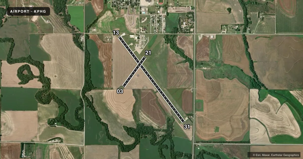
Runways & pattern
Full pagePattern entry · RWY 31
LEFT TRAFFIC| Runway | Heading (°M) | Length | Surface | Traffic |
|---|---|---|---|---|
| 13/31Favored | 138° / 318° | 5,101 ft | CONC | Standard L |
| 03/21 | 31° / 211° | 1,755 ft | TURF | Standard L |
Runway end performance
| End | TORA | TODA | ASDA | LDA | VGSI | Approach lights | Obstruction |
|---|---|---|---|---|---|---|---|
| 13 | — | — | — | — | PAPI 2-box left(3°) | — | — |
| 31 | — | — | — | — | PAPI 2-box left(3°) | — | 40', trees, 1228' from thr, 100' R of cntrln, slope 25 |
Declared distances in feet. TORA = takeoff run available, TODA = takeoff distance, ASDA = accelerate-stop, LDA = landing distance.
Airport sketch
Runways drawn to scale from FAA survey coordinates, rendered over satellite imagery. Not for navigation.
Approaches & charts
Services on the field
Fuel grades, oxygen, maintenance, ramp storage and lighting — as declared to the FAA by the airport operator.
Fuel & services
- Fuel
- 100LLA
- Oxygen (bottled)
- Not available
- Oxygen (bulk)
- Not available
- Other services
- AGRI
Ramp & ground
- Transient storage
- Tie-down
- Hangar
- Landing fee
- No fee published
- Customs
- Not available
- Lighting schedule
- SEE RMK
- Beacon schedule
- SS-SR
- Beacon
- White / Green (civil land)(WG)
- Wind indicator
- Lighted
- Segmented circle
- Yes
Fuel & FBOs
Cheapest 100LL and Jet A on the field and nearby. Always confirm with the FBO before taxi.
Airport notes
Surface conditions, obstructions, local procedures, lighting outages and other notes published with each FAA cycle.
General notes
- PUBLIC PHONE 24 HRS ACCESS.
- FOR CD CTC DENVER ARTCC AT 303-651-4257.
Lighting notes
- ACTVT REIL RWY 13 & 31; PAPI RWY 13 & 31; MIRL RWY 13/31 - CTAF.
Approach & departure obstructions
- 03MKD WITH RED AND WHITE WOOD "L" SHAPED MKRS.
- 21MKD WITH RED AND WHITE WOOD "L" SHAPED MKRS.
- 13RWY 13 PAPI UNUSBL BYD 8 DEGS L AND R OF CNTRLN.
Other notes
- MANAGERAFT HRS CALL 1-785-543-1941.
VFR map & nearby airports
VFR sectional. Tap any ICAO chip to open that airport.
Key facts · KPHG
Answer card- ICAO
- KPHG
- Name
- PHILLIPSBURG MUNI
- Location
- PHILLIPSBURG, KANSAS
- Elevation
- 1,910.1 ft MSL
- Traffic pattern altitude
- 2,910.1 ft MSL (1,000 AGL)
- Control tower
- Non-towered (use CTAF)
- Total runways
- 2
- Longest runway
- 13/31 · 5,101 ft
- Published ILS approaches
- 0
- Published frequencies
- 2
- Magnetic variation
- 5°
- Current flight rules
- VFR
- Current wind
- 000° at 2 kt
- Favored runway now
- RWY 31
Phillipsburg Muni sits in Phillipsburg, Kansas. The field elevation is 1,910.1 ft MSL. It has two runways. The longest is runway 13/31 at 5,101 ft on concrete. Runway 03/21 is 1,755 ft on turf. There is no control tower. CTAF and UNICOM are both 122.8.
No ILS approaches are published here. Pattern altitude is not published, so use standard light aircraft pattern planning unless the current Chart Supplement says otherwise. The on-field FBO is Phillipsburg Municipal Airport. It carries 100LL and Jet A. Call (785) 543-5424 for current service details before you go.
A few published remarks matter for a first-time arrival. Runway 13/31 has PAPI and medium intensity runway lights. The lights are controlled by CTAF. Runway end identifier lights are also on 13 and 31. Runway 13 PAPI is unusable more than 8 degrees left or right of centerline. Runway 21 and runway 03 are marked with red and white wood L-shaped markers. The airport also notes public phone access with 24-hour availability. For clearance delivery, contact Denver ARTCC at 303-651-4257. If you need the manager after hours, call 1-785-543-1941.