METAR & TAF K75
K75 does not publish a METAR.
Showing the nearest reporting station: KRSL (RUSSELL MUNI) · 34.3 NM away. Conditions at K75 may differ.
METAR · KRSL
Observed 14:53Z
KRSL 271453Z AUTO 22017KT 10SM CLR 34/15 A2981 RMK AO2 SLP069 T03390150 53000 $
- Wind
- 220° @ 17 kt
- Visibility
- 10 SM
- Temp / Dew
- 34°C / 15°C
- Altimeter
- 29.81 inHg
- Clouds
- CLR
- Density alt
- 4,335 ft
- Ceiling
- Unlimited
- Rules
- VFR
Airport info & contacts
Manager on record, flight service, ARTCC, attendance schedule and pattern altitude — published by the FAA and refreshed every 28 days.
Location
- From city
- 1 NM SE
- VFR sectional
- WICHITA
- ARTCC
- ZKC · KANSAS CITY
- NOTAM facility
- ICT (NOTAM-D)
Airport manager
- Name
- BARRY CURRY
- Phone
- 785-476-5270
- Address
- 128 N FIRST, OSBORNE KS 67473
Flight service · Hours
- FSS ICT
- WICHITA1-800-WX-BRIEF
- Attendance
- ON CALL
Frequencies
Tap any row to copy the frequency to your clipboard.
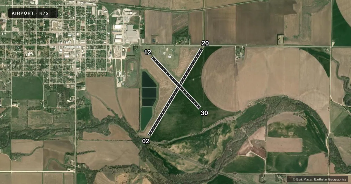
Runways & pattern
Full pagePattern entry · RWY 20
LEFT TRAFFIC| Runway | Heading (°M) | Length | Surface | Traffic |
|---|---|---|---|---|
| 02/20Favored | 23° / 203° | 4,206 ft | ASPH | Standard L |
| 12/30 | 129° / 309° | 2,907 ft | TURF | Standard L |
Runway end performance
| End | TORA | TODA | ASDA | LDA | VGSI | Approach lights | Obstruction |
|---|---|---|---|---|---|---|---|
| 02 | — | — | — | — | — | — | 30', trees, 301' from thr, 134' R of cntrln, slope 3 |
| 20 | — | — | — | — | — | — | 15', road, 201' from thr, 125' R of cntrln, slope 0 |
| 12 | — | — | — | — | — | — | 63', ant, 588' from thr, 135' R of cntrln, slope 9 |
| 30 | — | — | — | — | — | — | 8', crops, 0' from thr, 125' R of cntrln, slope 0 |
Declared distances in feet. TORA = takeoff run available, TODA = takeoff distance, ASDA = accelerate-stop, LDA = landing distance.
Airport sketch
Runways drawn to scale from FAA survey coordinates, rendered over satellite imagery. Not for navigation.
Approaches & charts
Services on the field
Fuel grades, oxygen, maintenance, ramp storage and lighting — as declared to the FAA by the airport operator.
Fuel & services
- Fuel
- 100LL
- Other services
- AGRI
Ramp & ground
- Transient storage
- Tie-down
- Hangar
- Landing fee
- No fee published
- Lighting schedule
- SS-SR
- Beacon schedule
- SS-SR
- Beacon
- White / Green (civil land)(WG)
- Wind indicator
- Yes
- Segmented circle
- No
Fuel & FBOs
Cheapest 100LL and Jet A on the field and nearby. Always confirm with the FBO before taxi.
Airport notes
Surface conditions, obstructions, local procedures, lighting outages and other notes published with each FAA cycle.
General notes
- FOR CD CTC KANSAS CITY ARTCC AT 913-254-8508.
Fuel notes
- 100LLAMGR.
Runway surface & condition
- 12/30OPEN SR-SS ONLY.
- 02/20NSTD SPACED BLUE THR LGTS.
Approach & departure obstructions
- 20CLOSE-IN OBSTN 15 FT RD, 0-199 FT DSTC, 125 FT L/R.
- 12THR & EDGES 8 IN X 10 FT STEEL BEAMS.
- 30THR & EDGES 8 IN X 10 FT STEEL BEAMS.
- 02OBSTN CLNC SLP 12:1 TO DTHR.
- 12CTLG OBSTN EXCEEDS 45 DEG SLP.
- 20OBSTN CLNC SLP 15:1 TO DTHR OVR 15 FT RD 152 FT DSTC.
- 30CROPS SURROUND RWY.
Other notes
- PROVIDED THE APPROACH TO EACH RWY IS MAINTAINED FOR A MINIMUM 20:1 GLIDE SLOPE AND THE TRANSITIONAL SURFACE BE MAINTAINED FOR A 7:1 SLOPE.
- 1AMGR.
VFR map & nearby airports
VFR sectional. Tap any ICAO chip to open that airport.
Key facts · K75
Answer card- ICAO
- K75
- Name
- OSBORNE MUNI
- Location
- OSBORNE, KANSAS
- Elevation
- 1,547 ft MSL
- Traffic pattern altitude
- 2,547 ft MSL (1,000 AGL)
- Control tower
- Non-towered (use CTAF)
- Total runways
- 2
- Longest runway
- 02/20 · 4,206 ft
- Published ILS approaches
- 0
- Published frequencies
- 1
- Magnetic variation
- 8°
- Current flight rules
- VFR
- Current wind
- 220° at 17 kt
- Favored runway now
- RWY 20
Osborne Muni is in Osborne, Kansas. Field elevation is 1,547 ft MSL. The airport has two runways. The longest is 4,206 ft of asphalt on 02/20. Runway 12/30 is 2,907 ft of turf. There is no control tower. CTAF is 122.9.
No ILS approaches are published here. Pattern altitude is not published, so use the standard 1,000 ft AGL for light piston traffic unless the current FAA Chart Supplement says otherwise. Curry's Flying Service is on the field. It carries 100LL. The airport manager also provides 100LL fuel.
A few published remarks matter for planning. Runways 12 and 30 are open from sunrise to sunset only. Runway 02 has a displaced threshold with a published obstruction clearance slope. Runway 20 has close-in road obstructions near the approach path. Runway 12 also has a cataloged obstruction issue near the runway. Runway 02/20 has nonstandard spaced blue threshold lights. This is a small non-towered field with mixed pavement and turf. Review the current FAA Chart Supplement before you go, especially if you plan to use the turf runway or arrive after daylight on 12/30.