METAR & TAF K61
K61 does not publish a METAR.
Showing the nearest reporting station: KCNK (BLOSSER MUNI) · 22.5 NM away. Conditions at K61 may differ.
METAR · KCNK
Observed 15:55Z
KCNK 271555Z AUTO 22011KT 10SM CLR 33/19 A2980 RMK AO2 SLP069 T03280194
- Wind
- 220° @ 11 kt
- Visibility
- 10 SM
- Temp / Dew
- 33°C / 19°C
- Altimeter
- 29.80 inHg
- Clouds
- CLR
- Density alt
- 4,068 ft
- Ceiling
- Unlimited
- Rules
- VFR
Airport info & contacts
Manager on record, flight service, ARTCC, attendance schedule and pattern altitude — published by the FAA and refreshed every 28 days.
Location
- From city
- 1 NM NW
- VFR sectional
- WICHITA
- ARTCC
- ZKC · KANSAS CITY
- NOTAM facility
- ICT (NOTAM-D)
Airport manager
- Name
- TRAVIS LATTIN FBO
- Phone
- 785-738-7437
- Address
- MORITZ MEMORIAL ARPT RR 3, BELOIT KS 67420
Flight service · Hours
- FSS ICT
- WICHITA1-800-WX-BRIEF
- Attendance
- MON-SAT · 0800-1800
Frequencies
Tap any row to copy the frequency to your clipboard.
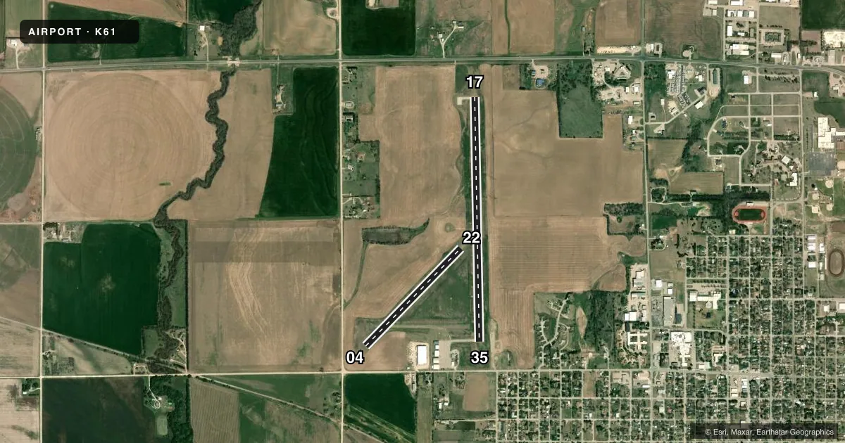
Runways & pattern
Full pagePattern entry · RWY 22
LEFT TRAFFIC| Runway | Heading (°M) | Length | Surface | Traffic |
|---|---|---|---|---|
| 17/35 | 174° / 354° | 4,200 ft | CONC | Standard L |
| 04/22Favored | 39° / 219° | 2,340 ft | TURF | Standard L |
Runway end performance
| End | TORA | TODA | ASDA | LDA | VGSI | Approach lights | Obstruction |
|---|---|---|---|---|---|---|---|
| 17 | 4,200' | 4,200' | 4,200' | 4,018' | PAPI 2-box left(4°) | — | 15', road, 610' from thr, 0' R of cntrln, slope 27 |
| 35 | 4,200' | 4,200' | 4,200' | 4,200' | PAPI 2-box left(3°) | — | 40', pole, 330' from thr, 245' R of cntrln, slope 3 |
| 04 | — | — | — | — | — | — | 35', pole, 310' from thr, 50' R of cntrln, slope 8 |
Declared distances in feet. TORA = takeoff run available, TODA = takeoff distance, ASDA = accelerate-stop, LDA = landing distance.
Airport sketch
Runways drawn to scale from FAA survey coordinates, rendered over satellite imagery. Not for navigation.
Approaches & charts
Services on the field
Fuel grades, oxygen, maintenance, ramp storage and lighting — as declared to the FAA by the airport operator.
Fuel & services
- Fuel
- 100LLA
- Airframe repair
- Major
- Power plant repair
- Major
- Other services
- AGRI,INSTR,RNTL,SALES
Ramp & ground
- Transient storage
- Tie-down
- Hangar
- Landing fee
- No fee published
- Customs
- Not available
- Lighting schedule
- SEE RMK
- Beacon schedule
- SS-SR
- Beacon
- White / Green (civil land)(WG)
- Wind indicator
- Lighted
- Segmented circle
- Yes
Fuel & FBOs
Cheapest 100LL and Jet A on the field and nearby. Always confirm with the FBO before taxi.
Airport notes
Surface conditions, obstructions, local procedures, lighting outages and other notes published with each FAA cycle.
General notes
- GLIDER OPS ON ARPT. RDO CTL OPS ON & INVOF ARPT; WKEND & HOL.
- FOR CD CTC KANSAS CITY ARTCC AT 913-254-8508.
- FUEL AVBL H24 WITH CREDIT CARD; SVC AFT HR - AMGR.
Lighting notes
- ACTVT MIRL 17/35; PAPI RWY 17 & 35 - CTAF.
Approach & departure obstructions
- 3525 FT DIRT MOUND 86 FT FM RWY END.
- 04RED & WHITE L MKRS WITH REFLECTOR RAISED PANELS.
- 22RED & WHITE L MKRS WITH REFLECTOR RAISED PANELS.
VFR map & nearby airports
VFR sectional. Tap any ICAO chip to open that airport.
Key facts · K61
Answer card- ICAO
- K61
- Name
- MORITZ MEML
- Location
- BELOIT, KANSAS
- Elevation
- 1,418.4 ft MSL
- Traffic pattern altitude
- 2,418.4 ft MSL (1,000 AGL)
- Control tower
- Non-towered (use CTAF)
- Total runways
- 2
- Longest runway
- 17/35 · 4,200 ft
- Published ILS approaches
- 0
- Published frequencies
- 2
- Magnetic variation
- 5°
- Current flight rules
- VFR
- Current wind
- 220° at 11 kt
- Favored runway now
- RWY 22
Moritz Meml Airport sits in Beloit, Kansas. The field elevation is 1,418.4 ft MSL. It has two runways. The longest is runway 17/35 at 4,200 ft of concrete. Runway 04/22 is 2,340 ft of turf. There is no control tower. CTAF and UNICOM are both 122.8. No ILS approaches are published here.
Pattern altitude is not published. Use 1,000 ft AGL as the standard light-piston pattern reference unless local procedures or ATC say otherwise. That puts the pattern at about 2,418 ft MSL based on the field elevation. The airport has medium intensity runway lights on 17/35. The PAPI for 17 and 35 is controlled on CTAF.
Lattin Aviation is on the field. It carries 100LL and Jet A Prist. Fuel is available 24 hours with credit card. After-hours service is available from the airport manager. Published remarks also call out glider activity on the airport. Radio-controlled operations happen on and near the field on weekends and holidays. Runway 35 has a 25-foot dirt mound 86 feet from the end. Runway 04 and runway 22 have red and white location markers with reflector raised panels. This is a non-towered field, so expect self-announce traffic and watch for mixed activity.