METAR & TAF 12K
12K does not publish a METAR.
Showing the nearest reporting station: KHJH (HEBRON MUNI) · 22.8 NM away. Conditions at 12K may differ.
METAR · KHJH
Observed 13:35Z
KHJH 271335Z AUTO 21006KT 10SM CLR 28/20 A2979 RMK AO2 T02800197
- Wind
- 210° @ 6 kt
- Visibility
- 10 SM
- Temp / Dew
- 28°C / 20°C
- Altimeter
- 29.79 inHg
- Clouds
- CLR
- Density alt
- 3,819 ft
- Ceiling
- Unlimited
- Rules
- VFR
Airport info & contacts
Manager on record, flight service, ARTCC, attendance schedule and pattern altitude — published by the FAA and refreshed every 28 days.
Location
- From city
- 2 NM N
- VFR sectional
- OMAHA
- ARTCC
- ZMP · MINNEAPOLIS
- NOTAM facility
- OLU (NOTAM-D)
Airport manager
- Name
- LUKE MEYERS
- Phone
- 402-879-3006
- Address
- 422 HIGHWAY 14, SUPERIOR NE 68978-9503
Flight service · Hours
- FSS OLU
- COLUMBUS1-800-WX-BRIEF
- Attendance
- MON-FRI · 0800-1700
Frequencies
Tap any row to copy the frequency to your clipboard.
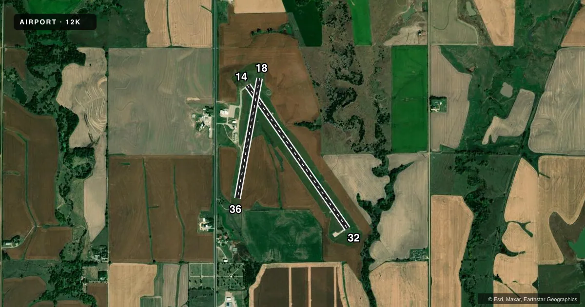
Runways & pattern
Full pagePattern entry · RWY 18
LEFT TRAFFIC| Runway | Heading (°M) | Length | Surface | Traffic |
|---|---|---|---|---|
| 14/32 | 140° / 320° | 4,301 ft | CONC | Standard L |
| 18/36Favored | 185° / 5° | 2,999 ft | TURF | Standard L |
Runway end performance
| End | TORA | TODA | ASDA | LDA | VGSI | Approach lights | Obstruction |
|---|---|---|---|---|---|---|---|
| 14 | — | — | — | — | PAPI 2-box left(3°) | — | — |
| 32 | — | — | — | — | PAPI 2-box left(3°) | — | 38', tree, 1018' from thr, 19' R of cntrln, slope 21 |
Declared distances in feet. TORA = takeoff run available, TODA = takeoff distance, ASDA = accelerate-stop, LDA = landing distance.
Airport sketch
Runways drawn to scale from FAA survey coordinates, rendered over satellite imagery. Not for navigation.
Approaches & charts
Services on the field
Fuel grades, oxygen, maintenance, ramp storage and lighting — as declared to the FAA by the airport operator.
Fuel & services
- Fuel
- 100LL
- Oxygen (bottled)
- Not available
- Oxygen (bulk)
- Not available
- Other services
- AGRI
Ramp & ground
- Transient storage
- Tie-down
- Hangar
- Landing fee
- No fee published
- Customs
- Not available
- Lighting schedule
- SEE RMK
- Beacon schedule
- SS-SR
- Beacon
- White / Green (civil land)(WG)
- Wind indicator
- Lighted
- Segmented circle
- Yes
Fuel & FBOs
Cheapest 100LL and Jet A on the field and nearby. Always confirm with the FBO before taxi.
Airport notes
Surface conditions, obstructions, local procedures, lighting outages and other notes published with each FAA cycle.
General notes
- FOR CD CTC MINNEAPOLIS ARTCC AT 651-463-5588.
Lighting notes
- ACTVT MIRL, PAPI & REIL RWY 14/32 - CTAF.
Approach & departure obstructions
- 14CLNC SLP 35:1 DUE TO ROAD, 21 FT ABV RWY END, 943 FT OUT, 327 R FM RWY END.
Other notes
- CALL 402-879-3006 TO ARNG HNGR STORAGE.
- 1FOR ATTENDANT AFT HRS CALL 402-879-5852 OR 402-879-1383.
- OWNERLUKE MEYERS, CHAIRMAN.
VFR map & nearby airports
VFR sectional. Tap any ICAO chip to open that airport.
Key facts · 12K
Answer card- ICAO
- 12K
- Name
- SUPERIOR MUNI
- Location
- SUPERIOR, NEBRASKA
- Elevation
- 1,691.5 ft MSL
- Traffic pattern altitude
- 2,691.5 ft MSL (1,000 AGL)
- Control tower
- Non-towered (use CTAF)
- Total runways
- 2
- Longest runway
- 14/32 · 4,301 ft
- Published ILS approaches
- 0
- Published frequencies
- 2
- Magnetic variation
- 5°
- Current flight rules
- VFR
- Current wind
- 210° at 6 kt
- Favored runway now
- RWY 18
Superior Muni sits in Superior, Nebraska. The field elevation is 1,691.5 ft MSL. It has two runways. The longest is runway 14/32 at 4,301 ft of concrete. Runway 18/36 is 2,999 ft of turf. There is no control tower. CTAF and UNICOM are both 123.0.
No ILS approaches are published here. Pattern altitude is not published in the facts, so plan to verify the current pattern altitude before arrival. For light piston traffic, use the standard 1,000 ft AGL only if the current Chart Supplement or local procedures support that. The published remarks also note medium intensity runway lights, PAPI and runway end identifier lights on runway 14/32. That helps after dark. You should still brief the field before you go.
Meyers Aerial Service is on the field. It carries 100LL. Call (402) 879-3006 for current service details. The remarks also list after-hours contact numbers for attendant support and hangar storage. One runway note matters for planning. Runway 14 has a 35:1 clearance slope because of a road near the departure end. If you are flying in from outside the area, check the current Chart Supplement for any noise or local operating notes before arrival. Clearance delivery is handled through Minneapolis ARTCC at 651-463-5588.