METAR & TAF 7V7
7V7 does not publish a METAR.
Showing the nearest reporting station: KHSI (HASTINGS MUNI) · 31.8 NM away. Conditions at 7V7 may differ.
METAR · KHSI
Observed 12:53Z
KHSI 271253Z AUTO 28005KT 10SM CLR 26/19 A2982 RMK AO2 SLP074 T02610194
- Wind
- 280° @ 5 kt
- Visibility
- 10 SM
- Temp / Dew
- 26°C / 19°C
- Altimeter
- 29.82 inHg
- Clouds
- CLR
- Density alt
- 3,607 ft
- Ceiling
- Unlimited
- Rules
- VFR
Airport info & contacts
Manager on record, flight service, ARTCC, attendance schedule and pattern altitude — published by the FAA and refreshed every 28 days.
Location
- From city
- 1 NM W
- VFR sectional
- OMAHA
- ARTCC
- ZMP · MINNEAPOLIS
- NOTAM facility
- OLU (NOTAM-D)
Airport manager
- Name
- DAYRE WILLIAMS
- Phone
- 402-746-2500
- Address
- 241 WEST 4TH AVENUE, RED CLOUD NE 68970-2357
Flight service · Hours
- FSS OLU
- COLUMBUS1-800-WX-BRIEF
- Attendance
- Unattended
Frequencies
Tap any row to copy the frequency to your clipboard.
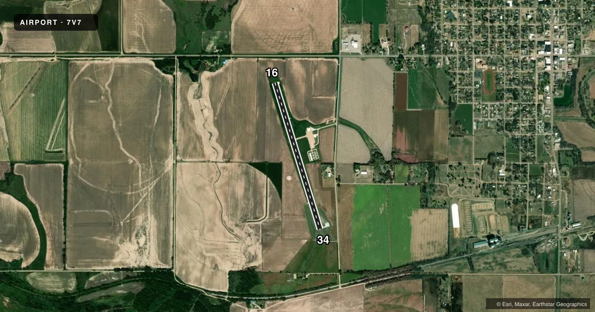
Runways & pattern
Full pagePattern entry · RWY 34
LEFT TRAFFICRunway end performance
| End | TORA | TODA | ASDA | LDA | VGSI | Approach lights | Obstruction |
|---|---|---|---|---|---|---|---|
| 16 | — | — | — | — | PAPI 2-box left(3.25°) | — | — |
| 34 | — | — | — | — | PAPI 2-box left(3°) | — | 47', tree, 1123' from thr, 252' R of cntrln, slope 19 |
Declared distances in feet. TORA = takeoff run available, TODA = takeoff distance, ASDA = accelerate-stop, LDA = landing distance.
Airport sketch
Runways drawn to scale from FAA survey coordinates, rendered over satellite imagery. Not for navigation.
Approaches & charts
Services on the field
Fuel grades, oxygen, maintenance, ramp storage and lighting — as declared to the FAA by the airport operator.
Fuel & services
- Fuel
- 100LL
- Oxygen (bottled)
- Not available
- Oxygen (bulk)
- Not available
- Airframe repair
- Not available
- Power plant repair
- Not available
- Other services
- AGRI
Ramp & ground
- Transient storage
- Tie-down
- Landing fee
- No fee published
- Customs
- Not available
- Lighting schedule
- SEE RMK
- Beacon schedule
- SS-SR
- Beacon
- White / Green (civil land)(WG)
- Wind indicator
- Lighted
- Segmented circle
- Yes
Fuel & FBOs
Cheapest 100LL and Jet A on the field and nearby. Always confirm with the FBO before taxi.
Airport notes
Surface conditions, obstructions, local procedures, lighting outages and other notes published with each FAA cycle.
General notes
- FOR CD CTC MINNEAPOLIS ARTCC AT 651-463-5588.
- COURTESY CAR AVBL.
Lighting notes
- DUSK-2300. MIRL RY 16/34 PRESET ON LOW INTST AND REIL RY 16/34 ON DUSK-2300; TO INCR INTST AND ACTVT PAPI RY 16/34 - CTAF; AFTER 2300 ACTVT MIRL RY 16/34, PAPI RY 16/34 AND REIL RY 16/34 - CTAF. FROM SR TO SS ACTVT PAPI RY 16/34 - CTAF.
Fuel notes
- 100LLFOR FUEL CALL 402- 746-2500 OR 746-3818.
Other notes
- OWNERDAYRE WILLIAMS CHAIRMAN.
VFR map & nearby airports
VFR sectional. Tap any ICAO chip to open that airport.
Key facts · 7V7
Answer card- ICAO
- 7V7
- Name
- RED CLOUD MUNI
- Location
- RED CLOUD, NEBRASKA
- Elevation
- 1,744.4 ft MSL
- Traffic pattern altitude
- 2,744.4 ft MSL (1,000 AGL)
- Control tower
- Non-towered (use CTAF)
- Total runways
- 1
- Longest runway
- 16/34 · 3,702 ft
- Published ILS approaches
- 0
- Published frequencies
- 1
- Magnetic variation
- 5°
- Current flight rules
- VFR
- Current wind
- 280° at 5 kt
- Favored runway now
- RWY 34
Red Cloud Muni is in Red Cloud, Nebraska. The field elevation is 1,744.4 ft MSL. It has one runway, 16/34, with a length of 3,702 ft on concrete. There is no control tower. CTAF is 122.9.
No ILS approaches are published here. The pattern altitude is not published, so use the standard 1,000 ft AGL for light piston operations unless the current Chart Supplement says otherwise. Runway lighting is pilot-controlled. The remarks say the medium intensity runway lights, REILs and PAPI on 16/34 have different activation settings by time of day. Review that before a night arrival.
Red Cloud Municipal Airport is the on-field FBO. It carries 100LL. For fuel, call the airport at the numbers in the Chart Supplement or contact the FBO directly by phone at (402) 746-3297. A courtesy car is available. For clearance delivery, contact Minneapolis ARTCC at 651-463-5588. Dayre Williams is listed as chairman. This is a non-towered field, so plan your radio work early and verify any current lighting or operational notes before you go.