METAR & TAF KHSI
Current METAR
Observed 14:53Z
KHSI 271453Z AUTO VRB04KT 10SM CLR 30/21 A2982 RMK AO2 SLP073 T03000206 51006
- Wind
- VAR @ 4 kt
- Visibility
- 10 SM
- Temp / Dew
- 30°C / 21°C
- Altimeter
- 29.82 inHg
- Clouds
- CLR
- Density alt
- 4,356 ft
- Ceiling
- Unlimited
- Rules
- VFR
Airport info & contacts
Manager on record, flight service, ARTCC, attendance schedule and pattern altitude — published by the FAA and refreshed every 28 days.
Location
- From city
- 2 NM NW
- VFR sectional
- OMAHA
- ARTCC
- ZMP · MINNEAPOLIS
- NOTAM facility
- HSI (NOTAM-D)
Airport manager
- Name
- MATTHEW KUHR
- Phone
- 402-984-5223
- Address
- 220 N. HASTINGS AVENUE, HASTINGS NE 68901-5144
Flight service · Hours
- FSS OLU
- COLUMBUS1-800-WX-BRIEF
- Attendance
- MON-FRI · 0800-1700
Frequencies
Tap any row to copy the frequency to your clipboard.
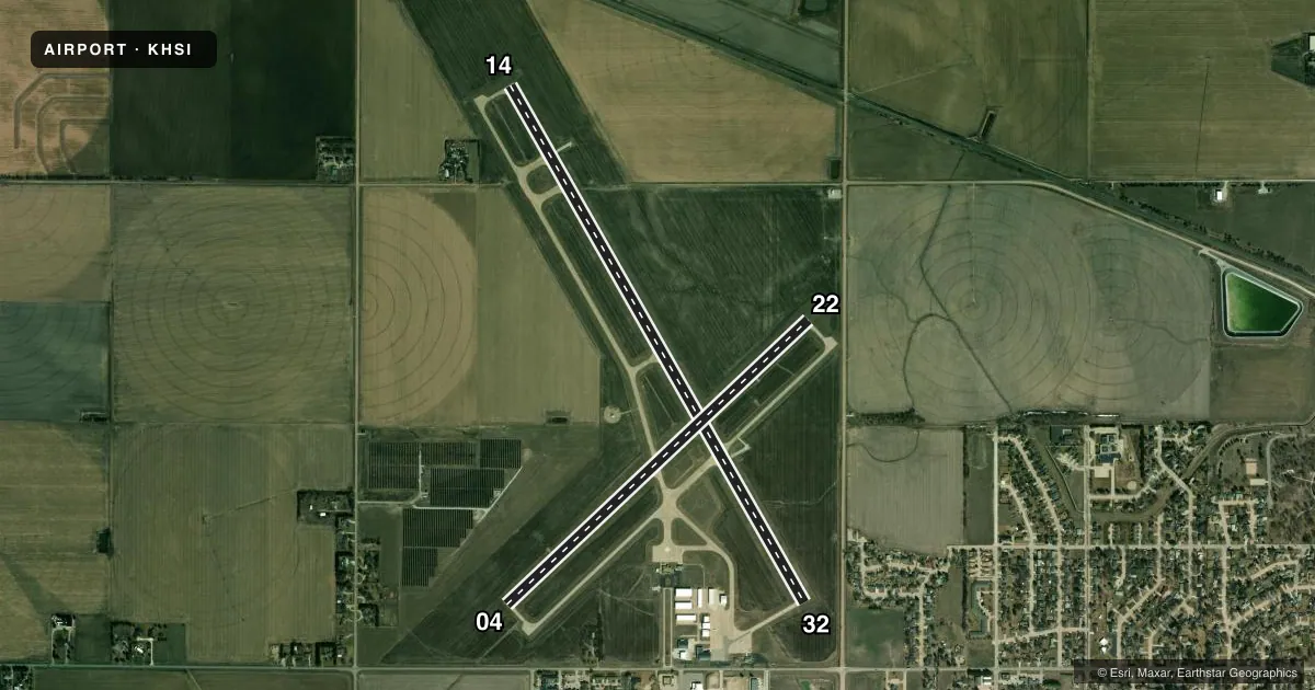
Runways & pattern
Full pagePattern entry · RWY 32
LEFT TRAFFIC| Runway | Heading (°M) | Length | Surface | Traffic |
|---|---|---|---|---|
| 14/32Favored | 143° / 323° | 6,451 ft | CONC | Standard L |
| 04/22 | 40° / 220° | 4,501 ft | CONC | Standard L |
Runway end performance
| End | TORA | TODA | ASDA | LDA | VGSI | Approach lights | Obstruction |
|---|---|---|---|---|---|---|---|
| 14 | 5,500' | 6,451' | 5,500' | 5,500' | PAPI 4-box left(3°) | — | — |
| 32 | 6,451' | 6,451' | 6,451' | 5,500' | PAPI 4-box right(3°) | — | 14', road, 364' from thr, 275' R of cntrln, slope 11 |
| 04 | — | — | — | — | PAPI 2-box left(3°) | — | — |
| 22 | — | — | — | — | PAPI 2-box left(3°) | — | — |
Declared distances in feet. TORA = takeoff run available, TODA = takeoff distance, ASDA = accelerate-stop, LDA = landing distance.
Airport sketch
Runways drawn to scale from FAA survey coordinates, rendered over satellite imagery. Not for navigation.
Approaches & charts
Services on the field
Fuel grades, oxygen, maintenance, ramp storage and lighting — as declared to the FAA by the airport operator.
Fuel & services
- Fuel
- 100LLA
- Oxygen (bottled)
- Not available
- Oxygen (bulk)
- Not available
- Airframe repair
- Major
- Power plant repair
- Major
- Other services
- AGRI,INSTR,RNTL
Ramp & ground
- Transient storage
- Tie-down
- Hangar
- Landing fee
- No fee published
- Customs
- Not available
- Lighting schedule
- SEE RMK
- Beacon schedule
- SS-SR
- Beacon
- White / Green (civil land)(WG)
- Wind indicator
- Lighted
- Segmented circle
- Yes
Fuel & FBOs
Cheapest 100LL and Jet A on the field and nearby. Always confirm with the FBO before taxi.
Airport notes
Surface conditions, obstructions, local procedures, lighting outages and other notes published with each FAA cycle.
General notes
- FOR CD CTC MINNEAPOLIS ARTCC AT 651-463-5588.
Lighting notes
- ACTVT MIRL RYS 04/22 & 14/32 AND PAPI RYS 04/22 & 14/32 AND REIL RYS 14 & 32 - CTAF.
Fuel notes
- 100LLSELF-SVC FUEL AVBL 24 HRS.
- AFUEL INJECTION ADDITIVES AVBL.
Approach & departure obstructions
- 04APCH RATIO 50:1 TO RWY THR.
- 14APCH RATIO 48:1 DUE TO RR TWR 35 FT ABV & 1884 FT FM RWY END; 166 L.
- 22APCH RATIO 50:1 TO RWY THR.
- 32APCH RATIO FM DSPLCD THR 50:1.
Other notes
- TO CONFIRM HNGR AVBL CALL 402-984-5223.
- MANAGERARPT CELL- MON-FRI 0800-1700 (402) 705-2420.
VFR map & nearby airports
VFR sectional. Tap any ICAO chip to open that airport.
Key facts · KHSI
Answer card- ICAO
- KHSI
- Name
- HASTINGS MUNI
- Location
- HASTINGS, NEBRASKA
- Elevation
- 1,961.2 ft MSL
- Traffic pattern altitude
- 2,961.2 ft MSL (1,000 AGL)
- Control tower
- Non-towered (use CTAF)
- Total runways
- 2
- Longest runway
- 14/32 · 6,451 ft
- Published ILS approaches
- 0
- Published frequencies
- 2
- Magnetic variation
- 7°
- Current flight rules
- VFR
- Current wind
- 000° at 4 kt
- Favored runway now
- RWY 32
Hastings Muni is in Hastings, Nebraska. The field elevation is 1,961.2 ft MSL. It has two concrete runways. The longest is 6,451 ft on 14/32. The other runway is 4,501 ft on 04/22. There is no control tower, so plan for CTAF operations on 122.8. No ILS approaches are published here.
Pattern altitude is not published. For light piston traffic, use 1,000 ft AGL unless the current Chart Supplement says otherwise. That puts the pattern at about 2,961 ft MSL based on the field elevation. Hastings Air is on the field. It carries 100LL and Jet A. Self-service 100LL is available 24 hours. Fuel injection additives are also listed.
This is a non-towered airport with a fairly high field elevation for Nebraska. Expect to pay attention to density altitude on warm days. Published remarks also note approach ratio limits on all runway ends. Runway 14 has a railroad tower near the approach path. Runway end identifier lights are available on 14 and 32. They operate on CTAF. Medium intensity runway lights and PAPI are available on both runways. For clearance delivery, contact Minneapolis ARTCC. If you need hangar space or want the latest operational details, call the airport manager or the airport operator before you go.