METAR & TAF 0V3
0V3 does not publish a METAR.
Showing the nearest reporting station: KEAR (KEARNEY RGNL) · 13.0 NM away. Conditions at 0V3 may differ.
METAR · KEAR
Observed 12:56Z
KEAR 271256Z AUTO 30005KT 10SM CLR 27/21 A2983 RMK AO2 SLP074 T02670211
- Wind
- 300° @ 5 kt
- Visibility
- 10 SM
- Temp / Dew
- 27°C / 21°C
- Altimeter
- 29.83 inHg
- Clouds
- CLR
- Density alt
- 4,230 ft
- Ceiling
- Unlimited
- Rules
- VFR
Airport info & contacts
Manager on record, flight service, ARTCC, attendance schedule and pattern altitude — published by the FAA and refreshed every 28 days.
Location
- From city
- 1 NM NE
- VFR sectional
- OMAHA
- ARTCC
- ZMP · MINNEAPOLIS
- NOTAM facility
- OLU (NOTAM-D)
Airport manager
- Name
- BRENT STEWART
- Phone
- 308-830-0391
- Address
- PO BOX 295, MINDEN NE 68959-0295
Flight service · Hours
- FSS OLU
- COLUMBUS1-800-WX-BRIEF
- Attendance
- Unattended
Frequencies
Tap any row to copy the frequency to your clipboard.
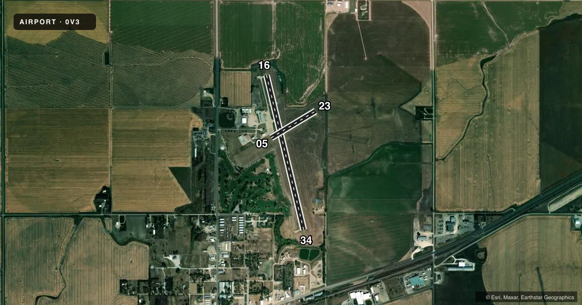
Runways & pattern
Full pagePattern entry · RWY 34
RIGHT TRAFFIC| Runway | Heading (°M) | Length | Surface | Traffic |
|---|---|---|---|---|
| 16/34Favored | 159° / 339° | 3,900 ft | CONC | 34 R |
| 05/23 | 52° / 232° | 1,275 ft | TURF | Standard L |
Runway end performance
| End | TORA | TODA | ASDA | LDA | VGSI | Approach lights | Obstruction |
|---|---|---|---|---|---|---|---|
| 16 | — | — | — | — | PAPI 2-box left(3°) | — | 5', fence, 340' from thr, 0' R of cntrln, slope 28 |
| 34 | — | — | — | — | PAPI 2-box left(3.5°) | — | 44', trees, 985' from thr, 256' R of cntrln, slope 17 |
Declared distances in feet. TORA = takeoff run available, TODA = takeoff distance, ASDA = accelerate-stop, LDA = landing distance.
Airport sketch
Runways drawn to scale from FAA survey coordinates, rendered over satellite imagery. Not for navigation.
Approaches & charts
Services on the field
Fuel grades, oxygen, maintenance, ramp storage and lighting — as declared to the FAA by the airport operator.
Fuel & services
- Fuel
- 100LL
- Oxygen (bottled)
- Not available
- Oxygen (bulk)
- Not available
- Other services
- AGRI
Ramp & ground
- Transient storage
- Tie-down
- Landing fee
- No fee published
- Customs
- Not available
- Lighting schedule
- SEE RMK
- Beacon schedule
- SS-SR
- Beacon
- White / Green (civil land)(WG)
- Wind indicator
- Lighted
- Segmented circle
- Yes
Fuel & FBOs
Cheapest 100LL and Jet A on the field and nearby. Always confirm with the FBO before taxi.
Airport notes
Surface conditions, obstructions, local procedures, lighting outages and other notes published with each FAA cycle.
General notes
- TWR 1163 FT AGL 3240 FT MSL 9 NM ENE.
- ULTRALIGHT ACTVY ON AND INVOF ARPT.
- FOR CD CTC MINNEAPOLIS ARTCC AT 651-463-5588.
Lighting notes
- ACTVT PAPI RWYS 16 & 34; MIRL RWY 16/34 - CTAF.
Approach & departure obstructions
- 05RWY 23 UNLGTD PIVOT IRRIGATION SYS ROTS THROUGH APCH AREA DURING IRRIGATION SEASON. PIVOT IS 16 FT ABV; 205 FT OUT, 0B; 12:1 WHEN IN APCH.
- 16UNLIGHTED PIVOT IRRIGATION SYSTEM ROTATES THROUGH APPROACH AREA DURING IRRIGATION SEASON.
- 23GAS LINE MARKER POLE.
Other notes
- MANAGERFOR SVC CTC BRENT 308-830-0391.
VFR map & nearby airports
VFR sectional. Tap any ICAO chip to open that airport.
Key facts · 0V3
Answer card- ICAO
- 0V3
- Name
- PIONEER VILLAGE FLD
- Location
- MINDEN, NEBRASKA
- Elevation
- 2,160.4 ft MSL
- Traffic pattern altitude
- 3,160.4 ft MSL (1,000 AGL)
- Control tower
- Non-towered (use CTAF)
- Total runways
- 2
- Longest runway
- 16/34 · 3,900 ft
- Published ILS approaches
- 0
- Published frequencies
- 2
- Magnetic variation
- 7°
- Current flight rules
- VFR
- Current wind
- 300° at 5 kt
- Favored runway now
- RWY 34
Pioneer Village Fld (0V3) sits in Minden, Nebraska. Field elevation is 2,160.4 ft MSL. The airport has two runways. The longest is 16/34 at 3,900 ft of concrete. Runway 05/23 is 1,275 ft of turf. There is no control tower. CTAF and UNICOM are both 122.7. No ILS approaches are published.
Pattern altitude is not published, so use the standard 1,000 ft AGL for light piston operations unless the current Chart Supplement says otherwise. Pioneer Village Field is on the field and carries AVGAS 100LL. Call (308) 830-2727 for current service details. Published remarks also note a gas line marker pole near runway 23. An unlighted pivot irrigation system can move through the approach area for runway 16 during irrigation season. Another pivot can affect the runway 23 approach area during irrigation season. Ultralight activity also occurs on and near the airport.
For a first-time arrival, the main thing to watch is the non-towered flow on 122.7 plus the irrigation and obstruction notes. Runway 16/34 has PAPI and medium intensity runway lights. Use CTAF for lighting. The field sits at a higher elevation than many Nebraska strips, so expect some performance loss on warm days. Check the current Chart Supplement for any additional local procedures before you go in.