METAR & TAF 08K
08K does not publish a METAR.
Showing the nearest reporting station: KAUH (AURORA MUNI/AL POTTER FLD) · 15.1 NM away. Conditions at 08K may differ.
METAR · KAUH
Observed 15:15Z
KAUH 271515Z AUTO 36003KT 10SM CLR 30/24 A2981 RMK AO2 T03030243
- Wind
- 360° @ 3 kt
- Visibility
- 10 SM
- Temp / Dew
- 30°C / 24°C
- Altimeter
- 29.81 inHg
- Clouds
- CLR
- Density alt
- 4,186 ft
- Ceiling
- Unlimited
- Rules
- VFR
Airport info & contacts
Manager on record, flight service, ARTCC, attendance schedule and pattern altitude — published by the FAA and refreshed every 28 days.
Location
- From city
- 2 NM NE
- VFR sectional
- OMAHA
- ARTCC
- ZMP · MINNEAPOLIS
- NOTAM facility
- OLU (NOTAM-D)
Airport manager
- Name
- TIM KRIENERT
- Phone
- 402-266-1890
- Address
- 13 AIRBASE ROAD, FAIRMONT STATE AIRFIELD, FAIRMONT NE 68354-4057
Flight service · Hours
- FSS OLU
- COLUMBUS1-800-WX-BRIEF
- Attendance
- Unattended
Frequencies
Tap any row to copy the frequency to your clipboard.
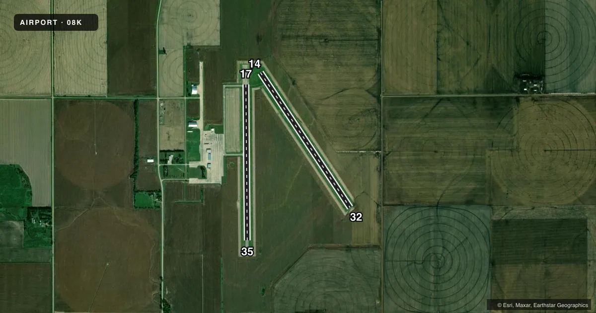
Runways & pattern
Full pagePattern entry · RWY 35
LEFT TRAFFICAirport sketch
Runways drawn to scale from FAA survey coordinates, rendered over satellite imagery. Not for navigation.
Approaches & charts
Services on the field
Fuel grades, oxygen, maintenance, ramp storage and lighting — as declared to the FAA by the airport operator.
Fuel & services
- Fuel
- 100LL
- Oxygen (bottled)
- Not available
- Oxygen (bulk)
- Not available
- Airframe repair
- Not available
- Power plant repair
- Not available
- Other services
- AGRI
Ramp & ground
- Transient storage
- Tie-down
- Landing fee
- No fee published
- Customs
- Not available
- Lighting schedule
- SEE RMK
- Beacon schedule
- SS-SR
- Beacon
- White / Green (civil land)(WG)
- Wind indicator
- Lighted
- Segmented circle
- Yes
Fuel & FBOs
Cheapest 100LL and Jet A on the field and nearby. Always confirm with the FBO before taxi.
Airport notes
Surface conditions, obstructions, local procedures, lighting outages and other notes published with each FAA cycle.
General notes
- FOR CD CTC MINNEAPOLIS ARTCC AT 651-463-5588.
Lighting notes
- ACTVT MIRL RWY 17-35 - CTAF.
Fuel notes
- 100LLCTC AMGR FOR FUEL; CASH OR CK ONLY 402-266-1890.
Other notes
- EXISTED PRIOR TO 1959.
- 1AMGR LCTD OFFSITE; CALL FOR ASSISTANCE 402-266-1890.
VFR map & nearby airports
VFR sectional. Tap any ICAO chip to open that airport.
Key facts · 08K
Answer card- ICAO
- 08K
- Name
- HARVARD STATE
- Location
- HARVARD, NEBRASKA
- Elevation
- 1,814.5 ft MSL
- Traffic pattern altitude
- 2,814.5 ft MSL (1,000 AGL)
- Control tower
- Non-towered (use CTAF)
- Total runways
- 2
- Longest runway
- 14/32 · 3,873 ft
- Published ILS approaches
- 0
- Published frequencies
- 1
- Magnetic variation
- 5°
- Current flight rules
- VFR
- Current wind
- 360° at 3 kt
- Favored runway now
- RWY 35
Harvard State Airport is in Harvard, Nebraska. The field elevation is 1,814.5 ft MSL. It has two runways. The longest is runway 14/32 at 3,873 ft. Runway 17/35 is asphalt at 3,722 ft. This is an untowered field, so plan to self-announce on CTAF 122.9. Keep a close scan in the pattern.
No ILS approaches are published here. The pattern altitude is not published in the facts, so use the current Chart Supplement before you fly. The published remarks also note that runway 17/35 medium intensity lights are activated through CTAF use. That matters if you are arriving near dusk or after dark. Fuel is handled through the airport manager. Call 402-266-1890 for fuel and airport assistance. Payment is cash or check only. No on-field FBOs are listed, so verify current services before departure.
For first-time pilots, the main things to plan for are the high field elevation, the mixed turf and asphalt runways and the lack of tower service. Check the current Chart Supplement for any local procedures before arrival. If you need clearance delivery, the published contact is Minneapolis ARTCC at 651-463-5588.