METAR & TAF KHJH
Current METAR
Observed 16:15Z
KHJH 271615Z AUTO 24006KT 10SM CLR 31/21 A2981 RMK AO2 T03130208
- Wind
- 240° @ 6 kt
- Visibility
- 10 SM
- Temp / Dew
- 31°C / 21°C
- Altimeter
- 29.81 inHg
- Clouds
- CLR
- Density alt
- 3,877 ft
- Ceiling
- Unlimited
- Rules
- VFR
Airport info & contacts
Manager on record, flight service, ARTCC, attendance schedule and pattern altitude — published by the FAA and refreshed every 28 days.
Location
- From city
- 1 NM S
- VFR sectional
- OMAHA
- ARTCC
- ZMP · MINNEAPOLIS
- NOTAM facility
- HJH (NOTAM-D)
Airport manager
- Name
- WILLIAM LINTON
- Phone
- (402) 768-6597
- Address
- 1115 OLIVE AVE, HEBRON NE 68370-1317
Flight service · Hours
- FSS OLU
- COLUMBUS1-800-WX-BRIEF
- Attendance
- Unattended
Frequencies
Tap any row to copy the frequency to your clipboard.
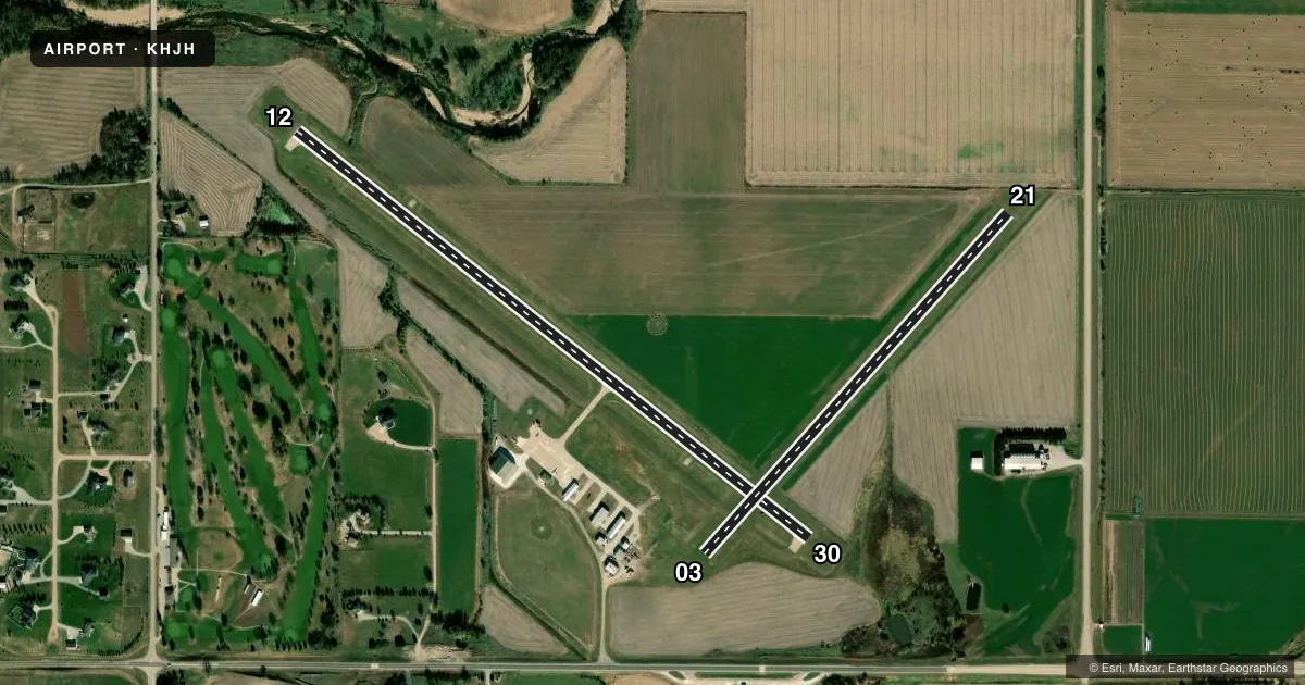
Runways & pattern
Full pagePattern entry · RWY 21
LEFT TRAFFIC| Runway | Heading (°M) | Length | Surface | Traffic |
|---|---|---|---|---|
| 12/30 | 124° / 304° | 3,600 ft | CONC | Standard L |
| 03/21Favored | 38° / 218° | 2,513 ft | TURF | Standard L |
Runway end performance
| End | TORA | TODA | ASDA | LDA | VGSI | Approach lights | Obstruction |
|---|---|---|---|---|---|---|---|
| 12 | — | — | — | — | PAPI 2-box left(3.9°) | — | 61', tree, 1428' from thr, 315' R of cntrln, slope 20 |
| 30 | — | — | — | — | PAPI 2-box left(3°) | — | 27', road, 743' from thr, 0' R of cntrln, slope 20 |
| 03 | — | — | — | — | — | — | 54', trees, 1085' from thr, 222' R of cntrln, slope 20 |
Declared distances in feet. TORA = takeoff run available, TODA = takeoff distance, ASDA = accelerate-stop, LDA = landing distance.
Airport sketch
Runways drawn to scale from FAA survey coordinates, rendered over satellite imagery. Not for navigation.
Approaches & charts
Services on the field
Fuel grades, oxygen, maintenance, ramp storage and lighting — as declared to the FAA by the airport operator.
Fuel & services
- Fuel
- 100LLA
- Oxygen (bottled)
- Not available
- Oxygen (bulk)
- Not available
- Other services
- AGRI,INSTR
Ramp & ground
- Transient storage
- Tie-down
- Hangar
- Landing fee
- No fee published
- Customs
- Not available
- Lighting schedule
- SEE RMK
- Beacon schedule
- SS-SR
- Beacon
- White / Green (civil land)(WG)
- Wind indicator
- Lighted
- Segmented circle
- Yes
Fuel & FBOs
Cheapest 100LL and Jet A on the field and nearby. Always confirm with the FBO before taxi.
Airport notes
Surface conditions, obstructions, local procedures, lighting outages and other notes published with each FAA cycle.
General notes
- APCHS PROTECTED BY STRUCTURE CTL ORDINANCE.
- FOR CD CTC MINNEAPOLIS ARTCC AT 651-463-5588.
Lighting notes
- ACTVT MIRL RY 12/30; PAPI & REIL RYS 12 & 30 - CTAF.
Fuel notes
- 100LLFUEL AVBL H24 VIA CREDIT CARD. IF UNAVBL CALL (402) 768-6597.
Approach & departure obstructions
- 03MKD WITH REFLECTORS & YELLOW CONES.
- 21MKD WITH REFLECTORS & YELLOW CONES.
- 03RWY 21 8 FT TALL CORN IN SUMMER CAN CREATE 22:1.
- 21RWY 21 8 FT TALL CORN IN SUMMER CAN CREATE 22:1.
Other notes
- AIRFRAME RPRS BY APNTMT ONLY.
- THIS AIRPORT HAS BEEN SURVEYED BY THE NATIONAL GEODETIC SURVEY.
- PWR PLANT RPRS BY APNTMT ONLY.
- TNST HNGR SPACE CALL FOR AVBLTY (402) 765-5697.
VFR map & nearby airports
VFR sectional. Tap any ICAO chip to open that airport.
Key facts · KHJH
Answer card- ICAO
- KHJH
- Name
- HEBRON MUNI
- Location
- HEBRON, NEBRASKA
- Elevation
- 1,468.2 ft MSL
- Traffic pattern altitude
- 2,468.2 ft MSL (1,000 AGL)
- Control tower
- Non-towered (use CTAF)
- Total runways
- 2
- Longest runway
- 12/30 · 3,600 ft
- Published ILS approaches
- 0
- Published frequencies
- 1
- Magnetic variation
- 4°
- Current flight rules
- VFR
- Current wind
- 240° at 6 kt
- Favored runway now
- RWY 21
Hebron Muni sits in Hebron, Nebraska at 1,468.2 ft MSL. It has two runways. The longest is 12/30 at 3,600 ft of concrete. The other runway is 03/21 at 2,513 ft of turf. There is no control tower, so expect CTAF operations on 122.9.
No ILS approaches are published here. Pattern altitude is not published, so use the standard 1,000 ft AGL pattern unless the current FAA Chart Supplement says otherwise. The field is lighted on runway 12/30 with medium intensity runway lights. PAPI and REIL are installed on runways 12 and 30. They are controlled by CTAF.
Hebron Municipal Airport is the on-field FBO. It carries 100LL and JET A. 100LL is available 24 hours by credit card. If it is unavailable, use the published phone number for help. Clearance delivery is handled through Minneapolis ARTCC. That matters if you need IFR release or a clearance before departure.
A first-time pilot should pay attention to the published runway notes. Runway 21 can have 8 ft corn in summer. That can create a 22 to 1 obstruction clearance slope. Runways 03 and 21 are marked with reflectors and yellow cones. The airport also has a structure control ordinance protecting approaches. Airframe and power plant repairs are by appointment only. Transient hangar space is available by phone.