METAR & TAF KCNK
Current METAR
Observed 12:55Z
KCNK 271255Z AUTO 20017G24KT 10SM CLR 28/19 A2979 RMK AO2 SLP064 T02780189
- Wind
- 200° @ 17G24 kt
- Visibility
- 10 SM
- Temp / Dew
- 28°C / 19°C
- Altimeter
- 29.79 inHg
- Clouds
- CLR
- Density alt
- 3,566 ft
- Ceiling
- Unlimited
- Rules
- VFR
Airport info & contacts
Manager on record, flight service, ARTCC, attendance schedule and pattern altitude — published by the FAA and refreshed every 28 days.
Location
- From city
- 2 NM S
- VFR sectional
- WICHITA
- ARTCC
- ZKC · KANSAS CITY
- NOTAM facility
- CNK (NOTAM-D)
Airport manager
- Name
- FULLER BATES
- Phone
- 785-243-2670
- Address
- 701 WASHINGTON, CONCORDIA KS 66901
Flight service · Hours
- FSS ICT
- WICHITA1-800-WX-BRIEF
- Attendance
- MON-FRI · 0800-1600
Frequencies
Tap any row to copy the frequency to your clipboard.
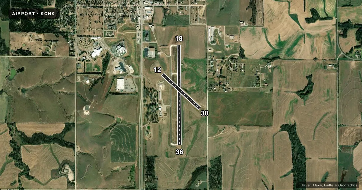
Runways & pattern
Full pagePattern entry · RWY 18
LEFT TRAFFIC| Runway | Heading (°M) | Length | Surface | Traffic |
|---|---|---|---|---|
| 18/36Favored | 174° / 354° | 4,000 ft | ASPH | Standard L |
| 12/30 | 126° / 306° | 2,040 ft | TURF | Standard L |
Runway end performance
| End | TORA | TODA | ASDA | LDA | VGSI | Approach lights | Obstruction |
|---|---|---|---|---|---|---|---|
| 18 | — | — | — | — | PAPI 4-box left(3°) | — | — |
| 36 | — | — | — | — | PAPI 4-box left(3°) | — | — |
| 12 | — | — | — | — | — | — | 35', pole, 176' from thr, 0' R of cntrln, slope 5 |
| 30 | — | — | — | — | — | — | 15', fence, 0' from thr, 50' R of cntrln, slope 0 |
Declared distances in feet. TORA = takeoff run available, TODA = takeoff distance, ASDA = accelerate-stop, LDA = landing distance.
Airport sketch
Runways drawn to scale from FAA survey coordinates, rendered over satellite imagery. Not for navigation.
Approaches & charts
Services on the field
Fuel grades, oxygen, maintenance, ramp storage and lighting — as declared to the FAA by the airport operator.
Fuel & services
- Fuel
- 100LLA+
- Other services
- AGRI
Ramp & ground
- Transient storage
- Tie-down
- Hangar
- Landing fee
- No fee published
- Customs
- Not available
- Lighting schedule
- SEE RMK
- Beacon schedule
- SS-SR
- Beacon
- White / Green (civil land)(WG)
- Wind indicator
- Yes
- Segmented circle
- Yes
Fuel & FBOs
Cheapest 100LL and Jet A on the field and nearby. Always confirm with the FBO before taxi.
Airport notes
Surface conditions, obstructions, local procedures, lighting outages and other notes published with each FAA cycle.
General notes
- RDO CTL MODEL AIRPLANE TO 400 FT EAST; EVENING, WKEND & HOL.
- FOR CD CTC KANSAS CITY ARTCC AT 913-254-8508.
- FUEL AVBL H24 WITH CREDIT CARD.
Lighting notes
- ACTVT REIL RWY 18 & 36; PAPI RWY 18 & 36 - CTAF. MIRL RWY 18/36 PRESET MED INTST DUSK-2200; AFT 2200 ACTVT - CTAF.
Approach & departure obstructions
- 18PAPI UNUSBL BYD 4 DEGS LEFT OF CNTRLN.
- 36PAPI UNUSBL BYD 6 DEGS LEFT OF CNTRLN.
- 12CTLG OBSTN EXCEEDS 45 DEG SLP.
VFR map & nearby airports
VFR sectional. Tap any ICAO chip to open that airport.
Key facts · KCNK
Answer card- ICAO
- KCNK
- Name
- BLOSSER MUNI
- Location
- CONCORDIA, KANSAS
- Elevation
- 1,488.1 ft MSL
- Traffic pattern altitude
- 2,488.1 ft MSL (1,000 AGL)
- Control tower
- Non-towered (use CTAF)
- Total runways
- 2
- Longest runway
- 18/36 · 4,000 ft
- Published ILS approaches
- 0
- Published frequencies
- 2
- Magnetic variation
- 6°
- Current flight rules
- VFR
- Current wind
- 200° at 17 kt
- Favored runway now
- RWY 18
Blosser Muni sits in Concordia, Kansas. Field elevation is 1,488.1 ft MSL. The airport has two runways. The longest is 18/36 at 4,000 ft asphalt. Runway 12/30 is 2,040 ft turf. There is no control tower. CTAF and UNICOM are both 122.8.
No ILS approaches are published here. Pattern altitude is not published, so use the standard 1,000 ft AGL for light piston traffic unless the current Chart Supplement says otherwise. The on-field FBO is Blosser Municipal Airport. It carries 100LL and Jet A. Fuel is available 24 hours a day with a credit card.
A few runway details matter here. Runway end identifier lights are active on 18 and 36. The PAPI on 18 and 36 works on the common traffic advisory frequency. The medium intensity runway lights on 18 and 36 are preset from dusk to 2200. After 2200, they are activated on CTAF. There is also a cataloged obstruction near runway 12 that exceeds a 45 degree slope. The PAPI on 18 is unusable beyond 4 degrees left of centerline. The PAPI on 36 is unusable beyond 6 degrees left of centerline. For clearance delivery, contact Kansas City ARTCC. If you are planning a night arrival or a first visit, brief the lighting setup and the runway 12 obstruction before you go.