METAR & TAF KRPB
KRPB does not publish a METAR.
Showing the nearest reporting station: KCNK (BLOSSER MUNI) · 16.1 NM away. Conditions at KRPB may differ.
METAR · KCNK
Observed 14:55Z
KCNK 271455Z AUTO 22015KT 10SM CLR 32/18 A2979 RMK AO2 PK WND 21027/1400 SLP066 T03170183 53001
- Wind
- 220° @ 15 kt
- Visibility
- 10 SM
- Temp / Dew
- 32°C / 18°C
- Altimeter
- 29.79 inHg
- Clouds
- CLR
- Density alt
- 4,108 ft
- Ceiling
- Unlimited
- Rules
- VFR
Airport info & contacts
Manager on record, flight service, ARTCC, attendance schedule and pattern altitude — published by the FAA and refreshed every 28 days.
Location
- From city
- 1 NM W
- VFR sectional
- WICHITA
- ARTCC
- ZMP · MINNEAPOLIS
- NOTAM facility
- ICT (NOTAM-D)
Airport manager
- Name
- BRIAN PHILLIPS
- Phone
- 785-527-3134
- Address
- 1819 L ST, BELLEVILLE KS 66935
Flight service · Hours
- FSS ICT
- WICHITA1-800-WX-BRIEF
- Attendance
- Unattended
Frequencies
Tap any row to copy the frequency to your clipboard.
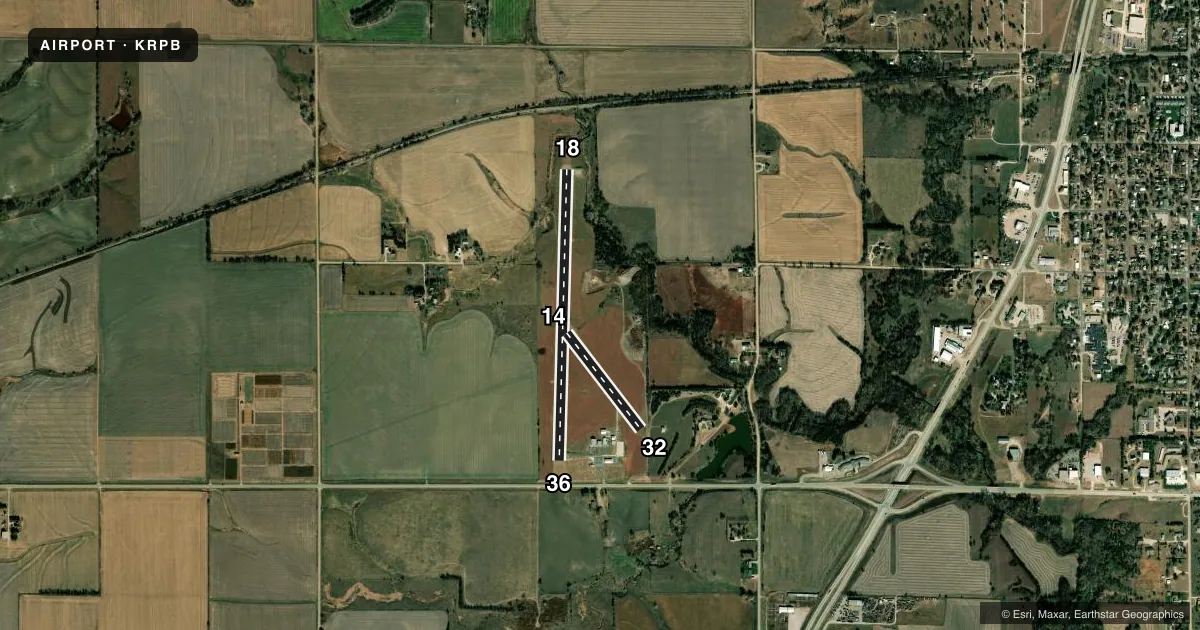
Runways & pattern
Full pagePattern entry · RWY 18
LEFT TRAFFIC| Runway | Heading (°M) | Length | Surface | Traffic |
|---|---|---|---|---|
| 18/36Favored | 175° / 355° | 3,500 ft | ASPH | Standard L |
| 14/32 | 135° / 315° | 1,461 ft | TURF | Standard L |
Runway end performance
| End | TORA | TODA | ASDA | LDA | VGSI | Approach lights | Obstruction |
|---|---|---|---|---|---|---|---|
| 18 | — | — | — | — | PAPI 2-box left(3°) | — | 40', trees, 315' from thr, 155' R of cntrln, slope 2 |
| 36 | — | — | — | — | PAPI 2-box left(3°) | — | 6', road, 280' from thr, 295' R of cntrln, slope 13 |
| 32 | — | — | — | — | — | — | 10', road, 0' from thr, 70' R of cntrln, slope 0 |
Declared distances in feet. TORA = takeoff run available, TODA = takeoff distance, ASDA = accelerate-stop, LDA = landing distance.
Airport sketch
Runways drawn to scale from FAA survey coordinates, rendered over satellite imagery. Not for navigation.
Approaches & charts
Services on the field
Fuel grades, oxygen, maintenance, ramp storage and lighting — as declared to the FAA by the airport operator.
Fuel & services
- Fuel
- 100LL
- Oxygen (bottled)
- Not available
- Oxygen (bulk)
- Not available
- Other services
- AGRI
Ramp & ground
- Transient storage
- Tie-down
- Hangar
- Landing fee
- No fee published
- Customs
- Not available
- Lighting schedule
- SEE RMK
- Beacon schedule
- SS-SR
- Beacon
- White / Green (civil land)(WG)
- Wind indicator
- Lighted
- Segmented circle
- Yes
Fuel & FBOs
Cheapest 100LL and Jet A on the field and nearby. Always confirm with the FBO before taxi.
Airport notes
Surface conditions, obstructions, local procedures, lighting outages and other notes published with each FAA cycle.
General notes
- FOR CD CTC MINNEAPOLIS ARTCC AT 651-463-5588.
Lighting notes
- ACTVT PAPI RWY 18 & 36; MIRL 18/36 - CTAF
Approach & departure obstructions
- 1825 FT TREES, 100-199 FT DSTC, 154 FT L.
- 14THLD MKD W/2 YELLOW CONES.
- 32THLD MKD W/2 "L" SHAPED MARKERS.
- 14CONTROLLING OBSTN EXCEEDS A 45 DEG SLP.
- 18ALSO 35 FT TREES, 400 FT DSTC, 165 FT L/R, OBSTN CLNC SLP 11:1.
Other notes
- 14/32SFC ROUGH.
VFR map & nearby airports
VFR sectional. Tap any ICAO chip to open that airport.
Key facts · KRPB
Answer card- ICAO
- KRPB
- Name
- BELLEVILLE MUNI
- Location
- BELLEVILLE, KANSAS
- Elevation
- 1,538 ft MSL
- Traffic pattern altitude
- 2,538 ft MSL (1,000 AGL)
- Control tower
- Non-towered (use CTAF)
- Total runways
- 2
- Longest runway
- 18/36 · 3,500 ft
- Published ILS approaches
- 0
- Published frequencies
- 2
- Magnetic variation
- 7°
- Current flight rules
- VFR
- Current wind
- 220° at 15 kt
- Favored runway now
- RWY 18
Belleville Muni sits in Belleville, Kansas. The field elevation is 1,538 ft MSL. It has two runways. The longest is 3,500 ft asphalt runway 18/36. Runway 14/32 is 1,461 ft turf. There is no control tower. CTAF and UNICOM are both 122.8.
No ILS approaches are published here. The pattern altitude is not published in the facts, so use the current Chart Supplement before you fly. The on-field FBO is Belleville Municipal Airport. It carries 100LL. Call ahead at (785) 527-2288 for current service details.
A few published remarks matter for planning. Runway 18 has trees near the approach path. Runway 14 has a controlling obstruction that exceeds a 45 degree slope. Runway 14/32 is rough. Runway 32 has two L-shaped threshold markers. Runways 18 and 36 have PAPI and medium intensity runway lights. For clearance delivery, Minneapolis ARTCC is listed in the remarks. This is a non-towered field at moderate elevation. Expect normal small-airport self-announce traffic flow. Verify the current Chart Supplement for any local procedures before arrival.