METAR & TAF K38
K38 does not publish a METAR.
Showing the nearest reporting station: KMYZ (MARYSVILLE MUNI) · 20.6 NM away. Conditions at K38 may differ.
METAR · KMYZ
Observed 12:55Z
KMYZ 271255Z AUTO 19008KT 10SM CLR 28/18 A2980 RMK AO2
- Wind
- 190° @ 8 kt
- Visibility
- 10 SM
- Temp / Dew
- 28°C / 18°C
- Altimeter
- 29.80 inHg
- Clouds
- CLR
- Density alt
- 3,490 ft
- Ceiling
- Unlimited
- Rules
- VFR
Airport info & contacts
Manager on record, flight service, ARTCC, attendance schedule and pattern altitude — published by the FAA and refreshed every 28 days.
Location
- From city
- 5 NM S
- VFR sectional
- WICHITA
- ARTCC
- ZKC · KANSAS CITY
- NOTAM facility
- ICT (NOTAM-D)
Airport manager
- Name
- JIMMY WORKMAN
- Phone
- 785-541-0533
- Address
- 303 C ST., WASHINGTON KS 66968
Flight service · Hours
- FSS ICT
- WICHITA1-800-WX-BRIEF
- Attendance
- Unattended
Frequencies
Tap any row to copy the frequency to your clipboard.
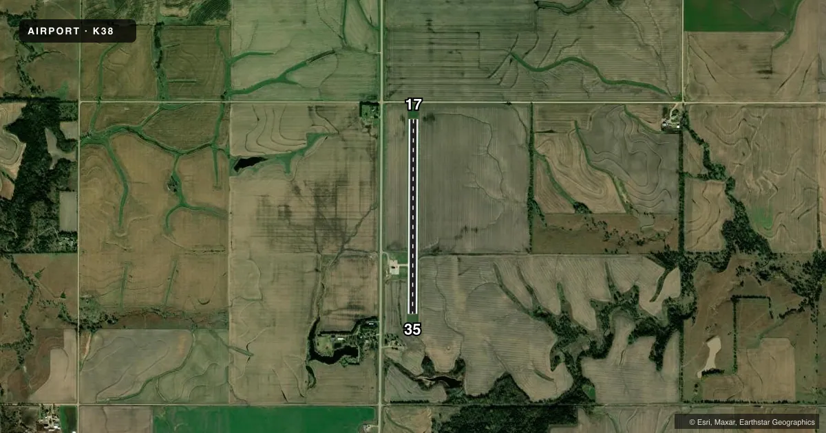
Runways & pattern
Full pagePattern entry · RWY 17
LEFT TRAFFICRunway end performance
| End | TORA | TODA | ASDA | LDA | VGSI | Approach lights | Obstruction |
|---|---|---|---|---|---|---|---|
| 17 | — | — | — | — | — | — | 15', road, 290' from thr, 300' R of cntrln, slope 6 |
| 35 | — | — | — | — | — | — | 68', pline, 1562' from thr, 0' R of cntrln, slope 20 |
Declared distances in feet. TORA = takeoff run available, TODA = takeoff distance, ASDA = accelerate-stop, LDA = landing distance.
Airport sketch
Runways drawn to scale from FAA survey coordinates, rendered over satellite imagery. Not for navigation.
Approaches & charts
Services on the field
Fuel grades, oxygen, maintenance, ramp storage and lighting — as declared to the FAA by the airport operator.
Fuel & services
- Fuel
- Not available
- Other services
- AGRI
Ramp & ground
- Transient storage
- Tie-down
- Landing fee
- No fee published
- Lighting schedule
- SEE RMK
- Beacon schedule
- SS-SR
- Beacon
- White / Green (civil land)(WG)
- Wind indicator
- Yes
- Segmented circle
- No
Fuel & FBOs
Cheapest 100LL and Jet A on the field and nearby. Always confirm with the FBO before taxi.
Airport notes
Surface conditions, obstructions, local procedures, lighting outages and other notes published with each FAA cycle.
General notes
- 24 HR PHONE AVBL FOR PUBLIC USE WITH PHONE CARD.
- FOR CD CTC KANSAS CITY ARTCC AT 913-254-8508.
Lighting notes
- ACTVT MIRL RWY 17/35 - CTAF.
Approach & departure obstructions
- 17EXTENSIVE PAVEMENT CRACKING & LOOSE STONES.
- 17OBSTN CLNC SLP 34:1 TO THE DTHR.
Other notes
- E111 PRVDD THE APCH TO EACH RWY IS MAINTD FOR A MIN 20:1 GLIDE SLOPE AND THE TRANSITIONAL SFC BE MAINTD FOR A 7:1 SLOPE.
- MANAGERPUBLIC WORKS DIRECTOR. ASST MGR BRAD FORTENIER, 785-747-6640, BRAD@BRADFORDBUILT.NET
- OWNERALSO WASHINGTON CO PUBLIC WORKS- WCPW@BLUEVALLEY.NET 785-541-0533.
VFR map & nearby airports
VFR sectional. Tap any ICAO chip to open that airport.
Key facts · K38
Answer card- ICAO
- K38
- Name
- WASHINGTON COUNTY VETERAN'S MEML
- Location
- WASHINGTON, KANSAS
- Elevation
- 1,436.5 ft MSL
- Traffic pattern altitude
- 2,436.5 ft MSL (1,000 AGL)
- Control tower
- Non-towered (use CTAF)
- Total runways
- 1
- Longest runway
- 17/35 · 3,406 ft
- Published ILS approaches
- 0
- Published frequencies
- 1
- Magnetic variation
- 6°
- Current flight rules
- VFR
- Current wind
- 190° at 8 kt
- Favored runway now
- RWY 17
Washington County Veteran's Meml is in Washington, Kansas. The field elevation is 1,436.5 ft MSL. It has one runway, 17/35, which is 3,406 ft long. There is no control tower. CTAF is 122.9.
No ILS approaches are published here. The published pattern altitude is not listed, so use the standard 1,000 ft AGL pattern unless the current Chart Supplement says otherwise. The runway lighting on 17/35 is medium intensity. It is activated by CTAF. That helps for night arrivals, but you still need to verify current field conditions before you go.
There are no on-field FBOs listed in the facts. Contact the airport operator directly before arrival, or call the field on CTAF for current FBO availability. Published remarks also note a 24-hour public phone with a phone card. Runway 17 has extensive pavement cracking and loose stones. There is also an obstacle clearance note near the runway 17 displaced threshold. Clearance delivery is handled through Kansas City ARTCC. This is a small non-towered field, so plan your arrival, review the runway condition and check the current Chart Supplement for anything else that affects your flight.