METAR & TAF 45K
45K does not publish a METAR.
Showing the nearest reporting station: KSLN (SALINA RGNL) · 18.5 NM away. Conditions at 45K may differ.
METAR · KSLN
Observed 12:53Z
KSLN 271253Z 19013KT 10SM CLR 28/19 A2983 RMK AO2 SLP081 T02830189
- Wind
- 190° @ 13 kt
- Visibility
- 10 SM
- Temp / Dew
- 28°C / 19°C
- Altimeter
- 29.83 inHg
- Clouds
- CLR
- Density alt
- 3,217 ft
- Ceiling
- Unlimited
- Rules
- VFR
Airport info & contacts
Manager on record, flight service, ARTCC, attendance schedule and pattern altitude — published by the FAA and refreshed every 28 days.
Location
- From city
- 2 NM SW
- VFR sectional
- WICHITA
- ARTCC
- ZKC · KANSAS CITY
- NOTAM facility
- ICT (NOTAM-D)
Airport manager
- Name
- SHANE DONOVAN
- Phone
- 785-392-3300
- Address
- K HWY 106, BOX 42 991, MINNEAPOLIS KS 67467
Flight service · Hours
- FSS ICT
- WICHITA1-800-WX-BRIEF
- Attendance
- APR-NOV · DAWN-DUSK
Frequencies
Tap any row to copy the frequency to your clipboard.
Runways & pattern
Full pagePattern entry · RWY 16
LEFT TRAFFICRunway end performance
| End | TORA | TODA | ASDA | LDA | VGSI | Approach lights | Obstruction |
|---|---|---|---|---|---|---|---|
| 16 | — | — | — | — | — | — | 65', trees, 1120' from thr, 215' R of cntrln, slope 14 |
| 34 | — | — | — | — | — | — | 30', trees, 201' from thr, 125' R of cntrln, slope 0 |
Declared distances in feet. TORA = takeoff run available, TODA = takeoff distance, ASDA = accelerate-stop, LDA = landing distance.
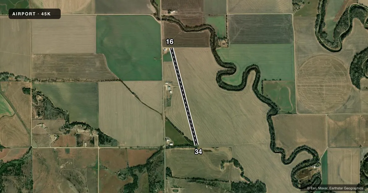
Airport sketch
Runways drawn to scale from FAA survey coordinates, rendered over satellite imagery. Not for navigation.
Approaches & charts
Services on the field
Fuel grades, oxygen, maintenance, ramp storage and lighting — as declared to the FAA by the airport operator.
Fuel & services
- Fuel
- Not available
- Other services
- AGRI
Ramp & ground
- Transient storage
- Tie-down
- Landing fee
- No fee published
- Wind indicator
- Yes
- Segmented circle
- No
Fuel & FBOs
Cheapest 100LL and Jet A on the field and nearby. Always confirm with the FBO before taxi.
Airport notes
Surface conditions, obstructions, local procedures, lighting outages and other notes published with each FAA cycle.
General notes
- ARPT OPERATES DAYLIGHT HRS ONLY.
- DEER ON & INVOF ARPT.
- FOR CD CTC KANSAS CITY ARTCC AT 913-254-8508.
Approach & departure obstructions
- 3430 FT TREES, 100-201 FT DSTC, 0-125 FT L.
- 16CONTROLLING OBSTN EXCEEDS A 45 DEG SLP.
Other notes
- PRVDD THE APCH TO EA RWY IS MAINTD FOR A MIN 20:1 GS AND TRANSITIONAL SFC MAINTD FOR A 7:1 SLOPE.
VFR map & nearby airports
VFR sectional. Tap any ICAO chip to open that airport.
Key facts · 45K
Answer card- ICAO
- 45K
- Name
- MINNEAPOLIS CITY COUNTY
- Location
- MINNEAPOLIS, KANSAS
- Elevation
- 1,246 ft MSL
- Traffic pattern altitude
- 2,246 ft MSL (1,000 AGL)
- Control tower
- Non-towered (use CTAF)
- Total runways
- 1
- Longest runway
- 16/34 · 3,970 ft
- Published ILS approaches
- 0
- Published frequencies
- 1
- Magnetic variation
- 7°
- Current flight rules
- VFR
- Current wind
- 190° at 13 kt
- Favored runway now
- RWY 16
Minneapolis City County Airport sits in Minneapolis, Kansas. Field elevation is 1,246 ft MSL. The airport has one runway, 16/34, which is 3,970 ft long and asphalt. There is no control tower. CTAF is 122.9.
No ILS approaches are published here. The pattern altitude is not published in the facts, so use the standard 1,000 ft AGL unless the current Chart Supplement says otherwise. That puts the traffic pattern at 2,246 ft MSL based on the field elevation, but verify before you fly. The airport operates during daylight hours only. Deer are on and near the airport. Runway 34 has trees 30 ft high near the approach area. Runway 16 has a controlling obstruction that exceeds a 45 degree slope.
There are no on-field FBOs listed in the facts. Plan on calling the airport operator or the field on CTAF for current services before arrival. For clearance delivery, contact Kansas City ARTCC at 913-254-8508. The published remarks also call out approach and transitional surface requirements, so this is a field where a careful look at the current Chart Supplement matters before you go.