METAR & TAF K78
K78 does not publish a METAR.
Showing the nearest reporting station: KSLN (SALINA RGNL) · 20.6 NM away. Conditions at K78 may differ.
METAR · KSLN
Observed 18:53Z
KSLN 271853Z 21016G25KT 10SM CLR 42/17 A2978 RMK AO2 PK WND 19030/1835 SLP064 T04170172
- Wind
- 210° @ 16G25 kt
- Visibility
- 10 SM
- Temp / Dew
- 42°C / 17°C
- Altimeter
- 29.78 inHg
- Clouds
- CLR
- Density alt
- 4,843 ft
- Ceiling
- Unlimited
- Rules
- VFR
Airport info & contacts
Manager on record, flight service, ARTCC, attendance schedule and pattern altitude — published by the FAA and refreshed every 28 days.
Location
- From city
- 1 NM SW
- VFR sectional
- WICHITA
- ARTCC
- ZKC · KANSAS CITY
- NOTAM facility
- ICT (NOTAM-D)
Airport manager
- Name
- JIM CURTIS
- Phone
- 785-263-3970
- Address
- 801 S. WASHINGTON, ABILENE KS 67410
Flight service · Hours
- FSS ICT
- WICHITA1-800-WX-BRIEF
- Attendance
- MON-SAT · 0800-1700
Frequencies
Tap any row to copy the frequency to your clipboard.
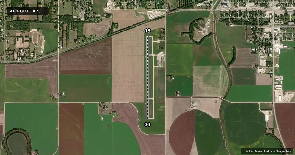
Runways & pattern
Full pagePattern entry · RWY 18
LEFT TRAFFICRunway end performance
| End | TORA | TODA | ASDA | LDA | VGSI | Approach lights | Obstruction |
|---|---|---|---|---|---|---|---|
| 18 | 4,100' | 4,100' | 4,100' | 3,914' | PAPI 2-box left(3°) | — | 36', trees, 745' from thr, 370' R of cntrln, slope 15 |
| 36 | 4,100' | 4,100' | 4,100' | 4,100' | PAPI 2-box left(3°) | — | 15', road, 746' from thr, 319' R of cntrln, slope 36 |
Declared distances in feet. TORA = takeoff run available, TODA = takeoff distance, ASDA = accelerate-stop, LDA = landing distance.
Airport sketch
Runways drawn to scale from FAA survey coordinates, rendered over satellite imagery. Not for navigation.
Approaches & charts
Services on the field
Fuel grades, oxygen, maintenance, ramp storage and lighting — as declared to the FAA by the airport operator.
Fuel & services
- Fuel
- 100LL
- Oxygen (bottled)
- Not available
- Oxygen (bulk)
- Not available
- Airframe repair
- Major
- Power plant repair
- Major
- Other services
- AGRI,INSTR,PAJA,RNTL
Ramp & ground
- Transient storage
- Tie-down
- Hangar
- Landing fee
- No fee published
- Customs
- Not available
- Lighting schedule
- SEE RMK
- Beacon schedule
- SS-SR
- Beacon
- White / Green (civil land)(WG)
- Wind indicator
- Lighted
- Segmented circle
- No
Fuel & FBOs
Cheapest 100LL and Jet A on the field and nearby. Always confirm with the FBO before taxi.
Airport notes
Surface conditions, obstructions, local procedures, lighting outages and other notes published with each FAA cycle.
General notes
- COURTESY CAR AVBL.
- FOR CD CTC KANSAS CITY ARTCC AT 913-254-8508.
Lighting notes
- MIRL RWY 18/36, PAPI RWY 18 & 36, REIL RWY 18 & 36 OPER DUSK-2200; OTHR TIMES ACTVT -- CTAF.
Fuel notes
- 100LL24 HR SELF SERVE FUEL.
Approach & departure obstructions
- 18REIL: LOW/ MEDIUM/ HIGH PILOT CTLD.
- 1823 RR, 630 FT FM THLD.
- 18OBSTN CLNC SLOPE 29:1 TO DSPLCD THLD.
VFR map & nearby airports
VFR sectional. Tap any ICAO chip to open that airport.
Key facts · K78
Answer card- ICAO
- K78
- Name
- ABILENE MUNI
- Location
- ABILENE, KANSAS
- Elevation
- 1,152.9 ft MSL
- Traffic pattern altitude
- 2,152.9 ft MSL (1,000 AGL)
- Control tower
- Non-towered (use CTAF)
- Total runways
- 1
- Longest runway
- 18/36 · 4,100 ft
- Published ILS approaches
- 0
- Published frequencies
- 4
- Magnetic variation
- 3°
- Current flight rules
- VFR
- Current wind
- 210° at 16 kt
- Favored runway now
- RWY 18
Abilene Muni sits in Abilene, Kansas. Field elevation is 1,152.9 ft MSL. The airport has one runway. Runway 18/36 is 4,100 ft long with a concrete surface. There is no control tower. Pattern altitude is not published, so use the standard 1,000 ft AGL for light piston traffic unless the current Chart Supplement says otherwise.
No ILS approaches are published here. That matters on marginal days. You will be working with non-precision options only. The field has medium intensity runway lights on 18/36. PAPI is installed on both ends. REILs are installed on both ends too. The REILs operate from dusk to 2200. After that, they are pilot activated on CTAF. Runway 18 also has pilot-controlled REIL with low, medium and high settings. There is a railroad 630 ft from the threshold of runway 18. The published obstacle clearance slope to the displaced threshold on 18 is 29 to 1.
Abilene Flying Service is on the field. It carries 100LL and Jet A Prist. 24-hour self-serve 100LL is available. A courtesy car is also available. For clearance delivery, contact Kansas City ARTCC. If you are planning a night or low-vis arrival, brief the lighting setup and the lack of ILS before you launch.