METAR & TAF KHRU
KHRU does not publish a METAR.
Showing the nearest reporting station: KMHK (MANHATTAN RGNL) · 27.6 NM away. Conditions at KHRU may differ.
METAR · KMHK
Observed 19:52Z
KMHK 271952Z AUTO 20010KT 10SM CLR 37/23 A2976 RMK AO2 SLP064 T03720233
- Wind
- 200° @ 10 kt
- Visibility
- 10 SM
- Temp / Dew
- 37°C / 23°C
- Altimeter
- 29.76 inHg
- Clouds
- CLR
- Density alt
- 4,674 ft
- Ceiling
- Unlimited
- Rules
- VFR
Airport info & contacts
Manager on record, flight service, ARTCC, attendance schedule and pattern altitude — published by the FAA and refreshed every 28 days.
Location
- From city
- 7 NM NE
- VFR sectional
- KANSAS CITY
- ARTCC
- ZKC · KANSAS CITY
- NOTAM facility
- ICT (NOTAM-D)
Airport manager
- Name
- MERLIN OSWALD
- Phone
- 785-258-2877
- Address
- 3134 US HWY 56, HERINGTON KS 67449
Flight service · Hours
- FSS ICT
- WICHITA1-800-WX-BRIEF
- Attendance
- Unattended
Frequencies
Tap any row to copy the frequency to your clipboard.
Runways & pattern
Full pagePattern entry · RWY 17
LEFT TRAFFICRunway end performance
| End | TORA | TODA | ASDA | LDA | VGSI | Approach lights | Obstruction |
|---|---|---|---|---|---|---|---|
| 17 | — | — | — | — | PAPI 4-box left(3°) | — | — |
| 35 | — | — | — | — | PAPI 4-box left(3°) | — | — |
Declared distances in feet. TORA = takeoff run available, TODA = takeoff distance, ASDA = accelerate-stop, LDA = landing distance.
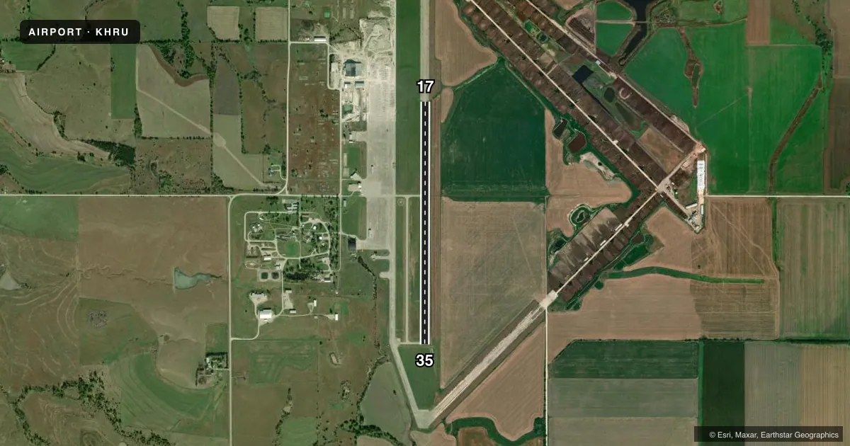
Airport sketch
Runways drawn to scale from FAA survey coordinates, rendered over satellite imagery. Not for navigation.
Approaches & charts
Services on the field
Fuel grades, oxygen, maintenance, ramp storage and lighting — as declared to the FAA by the airport operator.
Fuel & services
- Fuel
- 100LL
- Oxygen (bottled)
- Not available
- Oxygen (bulk)
- Not available
- Airframe repair
- Not available
- Power plant repair
- Not available
- Other services
- AGRI
Ramp & ground
- Transient storage
- Tie-down
- Landing fee
- No fee published
- Customs
- Not available
- Lighting schedule
- SEE RMK
- Beacon schedule
- SS-SR
- Beacon
- White / Green (civil land)(WG)
- Wind indicator
- Lighted
- Segmented circle
- Yes
Fuel & FBOs
Cheapest 100LL and Jet A on the field and nearby. Always confirm with the FBO before taxi.
Airport notes
Surface conditions, obstructions, local procedures, lighting outages and other notes published with each FAA cycle.
General notes
- RDO-CTLD MODEL ACFT ACTIVITY ON ARPT WKENDS & HOLS.
- FOR CD CTC KANSAS CITY ARTCC AT 913-254-8508.
Lighting notes
- ACTIVT REIL RWY 17 & 35, PAPI RWY 17 & 35, MIRL RWY 17/35 - CTAF.
Fuel notes
- 100LLFUEL 24 HRS SELF-SERVE.
Other notes
- EXISTED PRIOR TO 1959.
- 1FOR TRANSPORTATION CALL 785-258-2818.
- MANAGERASST AMGR 785-200-5019.
VFR map & nearby airports
VFR sectional. Tap any ICAO chip to open that airport.
Key facts · KHRU
Answer card- ICAO
- KHRU
- Name
- HERINGTON RGNL
- Location
- HERINGTON, KANSAS
- Elevation
- 1,480.6 ft MSL
- Traffic pattern altitude
- 2,480.6 ft MSL (1,000 AGL)
- Control tower
- Non-towered (use CTAF)
- Total runways
- 1
- Longest runway
- 17/35 · 4,184 ft
- Published ILS approaches
- 0
- Published frequencies
- 1
- Magnetic variation
- 6°
- Current flight rules
- VFR
- Current wind
- 200° at 10 kt
- Favored runway now
- RWY 17
Herington Regional Airport sits in Herington, Kansas. The field elevation is 1,480.6 ft MSL. It has one runway, 17/35, which is 4,184 ft long and paved concrete. There is no control tower. CTAF is 122.9. No ILS approaches are published here.
Pattern altitude is not published. Use the standard 1,000 ft AGL pattern for light piston operations unless local procedures or ATC say otherwise. Runway end identifier lights are installed on 17 and 35. PAPI is installed on both ends. Medium intensity runway lights are on runway 17/35 and are controlled by CTAF.
Herington Regional Airport carries AVGAS 100LL through the on-field FBO, Herington Regional Airport. 100LL is also available 24 hours via self-service. For clearance delivery, contact Kansas City Air Route Traffic Control Center. The published remarks also note radio-controlled model aircraft activity on weekends and holidays. That is worth keeping in mind if you are planning a busy arrival or departure window. The airport is a good one to brief carefully for lighting, CTAF use and local traffic flow before you go in.