METAR & TAF KFMZ
KFMZ does not publish a METAR.
Showing the nearest reporting station: KJYR (YORK MUNI) · 18.8 NM away. Conditions at KFMZ may differ.
METAR · KJYR
Observed 13:15Z
KJYR 271315Z AUTO 24006KT 10SM CLR 26/23 A2979 RMK AO2
- Wind
- 240° @ 6 kt
- Visibility
- 10 SM
- Temp / Dew
- 26°C / 23°C
- Altimeter
- 29.79 inHg
- Clouds
- CLR
- Density alt
- 3,510 ft
- Ceiling
- Unlimited
- Rules
- VFR
Airport info & contacts
Manager on record, flight service, ARTCC, attendance schedule and pattern altitude — published by the FAA and refreshed every 28 days.
Location
- From city
- 3 NM S
- VFR sectional
- OMAHA
- ARTCC
- ZMP · MINNEAPOLIS
- NOTAM facility
- OLU (NOTAM-D)
Airport manager
- Name
- TIM KRIENERT
- Phone
- 402-266-1890
- Address
- 13 AIRBASE ROAD, FAIRMONT STATE AIRFIELD, FAIRMONT NE 68354-4057
Flight service · Hours
- FSS OLU
- COLUMBUS1-800-WX-BRIEF
- Attendance
- MON-FRI · 0800-1700
Frequencies
Tap any row to copy the frequency to your clipboard.
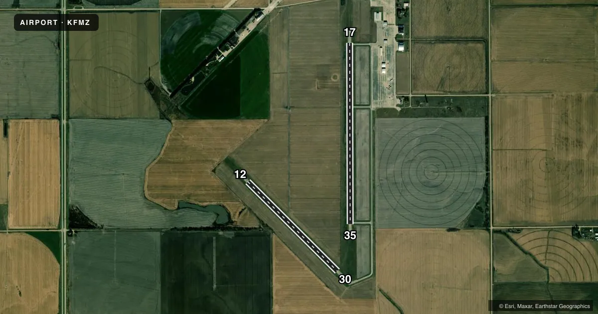
Runways & pattern
Full pagePattern entry · RWY 17
LEFT TRAFFICAirport sketch
Runways drawn to scale from FAA survey coordinates, rendered over satellite imagery. Not for navigation.
Approaches & charts
Services on the field
Fuel grades, oxygen, maintenance, ramp storage and lighting — as declared to the FAA by the airport operator.
Fuel & services
- Fuel
- 100LL
- Oxygen (bottled)
- Not available
- Oxygen (bulk)
- Not available
- Airframe repair
- Not available
- Power plant repair
- Not available
- Other services
- AGRI,INSTR
Ramp & ground
- Transient storage
- Tie-down
- Landing fee
- No fee published
- Customs
- Not available
- Lighting schedule
- SEE RMK
- Beacon schedule
- SS-SR
- Beacon
- White / Green (civil land)(WG)
- Wind indicator
- Lighted
- Segmented circle
- Yes
Fuel & FBOs
Cheapest 100LL and Jet A on the field and nearby. Always confirm with the FBO before taxi.
Airport notes
Surface conditions, obstructions, local procedures, lighting outages and other notes published with each FAA cycle.
General notes
- FOR CD CTC MINNEAPOLIS ARTCC AT 651-463-5588.
Lighting notes
- ACTVT MIRL RWY 17/35 - CTAF.
Fuel notes
- 100LLCTC AMGR FOR FUEL; CASH OR CK ONLY.
Other notes
- 1AMGR RESIDENCE ON ARPT.
- INSTRCTC THOMAS AVN FOR FLT INSTR.
- 12/30SGFNT CRACKS, SPALLS, & ALKALI-SILICA REACTIVITY.
VFR map & nearby airports
VFR sectional. Tap any ICAO chip to open that airport.
Key facts · KFMZ
Answer card- ICAO
- KFMZ
- Name
- FAIRMONT STATE
- Location
- FAIRMONT, NEBRASKA
- Elevation
- 1,636.4 ft MSL
- Traffic pattern altitude
- 2,636.4 ft MSL (1,000 AGL)
- Control tower
- Non-towered (use CTAF)
- Total runways
- 2
- Longest runway
- 17/35 · 4,317 ft
- Published ILS approaches
- 0
- Published frequencies
- 1
- Magnetic variation
- 3°
- Current flight rules
- VFR
- Current wind
- 240° at 6 kt
- Favored runway now
- RWY 17
Fairmont State Airport is in Fairmont, Nebraska. The field elevation is 1,636.4 ft MSL. It has two concrete runways. The longest is runway 17/35 at 4,317 ft. There is no control tower, so plan to use CTAF 122.9 for self-announce traffic.
No ILS approaches are published here. Pattern altitude is not published in the facts, so verify the current traffic pattern in the FAA Chart Supplement before you go. The airport sits in open Nebraska terrain. Wind and crosswind planning matter more than terrain clearance. Runway 12/30 has published surface issues. The remarks call out significant cracks, spalls and alkali-silica reactivity on that runway, so check the current condition before you commit to it.
No on-field FBOs are listed. Fuel is handled through the airport manager. The published remarks say 100LL is available through the airport manager. Payment is cash or check only. The airport manager's residence is on the airport. Runway 17/35 has medium intensity lights that are activated by CTAF. If you need clearance delivery, contact Minneapolis ARTCC at 651-463-5588. First-time arrivals should verify current runway condition, lighting use and any local procedures before departure.