METAR & TAF KAUH
Current METAR
Observed 22:35Z
KAUH 262235Z AUTO 16012KT 10SM CLR 36/27 A2980 RMK AO2 T03550271
- Wind
- 160° @ 12 kt
- Visibility
- 10 SM
- Temp / Dew
- 36°C / 27°C
- Altimeter
- 29.80 inHg
- Clouds
- CLR
- Density alt
- 4,905 ft
- Ceiling
- Unlimited
- Rules
- VFR
Airport info & contacts
Manager on record, flight service, ARTCC, attendance schedule and pattern altitude — published by the FAA and refreshed every 28 days.
Location
- From city
- 2 NM N
- VFR sectional
- OMAHA
- ARTCC
- ZMP · MINNEAPOLIS
- NOTAM facility
- AUH (NOTAM-D)
Airport manager
- Name
- TERRY OTT
- Phone
- 402-694-3633
- Address
- 1406 N HWY 14, 1406 NORTH HWY 14, AURORA NE 68818-1153
Flight service · Hours
- FSS OLU
- COLUMBUS1-800-WX-BRIEF
- Attendance
- MON-FRI · 0800-1700
Frequencies
Tap any row to copy the frequency to your clipboard.
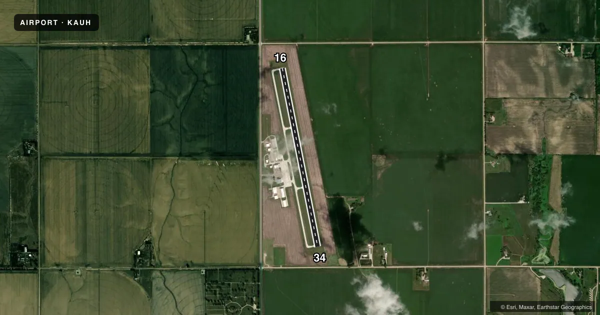
Runways & pattern
Full pagePattern entry · RWY 16
LEFT TRAFFICRunway end performance
| End | TORA | TODA | ASDA | LDA | VGSI | Approach lights | Obstruction |
|---|---|---|---|---|---|---|---|
| 16 | — | — | — | — | PAPI 2-box left(3°) | — | — |
| 34 | — | — | — | — | PAPI 2-box left(3°) | — | — |
Declared distances in feet. TORA = takeoff run available, TODA = takeoff distance, ASDA = accelerate-stop, LDA = landing distance.
Airport sketch
Runways drawn to scale from FAA survey coordinates, rendered over satellite imagery. Not for navigation.
Approaches & charts
Services on the field
Fuel grades, oxygen, maintenance, ramp storage and lighting — as declared to the FAA by the airport operator.
Fuel & services
- Fuel
- 100LL
- Oxygen (bottled)
- Not available
- Oxygen (bulk)
- Not available
- Airframe repair
- Not available
- Power plant repair
- Not available
- Other services
- AGRI,INSTR
Ramp & ground
- Transient storage
- Tie-down
- Hangar
- Landing fee
- No fee published
- Customs
- Not available
- Lighting schedule
- SEE RMK
- Beacon schedule
- SS-SR
- Beacon
- White / Green (civil land)(WG)
- Wind indicator
- Lighted
- Segmented circle
- No
Fuel & FBOs
Cheapest 100LL and Jet A on the field and nearby. Always confirm with the FBO before taxi.
Airport notes
Surface conditions, obstructions, local procedures, lighting outages and other notes published with each FAA cycle.
General notes
- COURTESY CAR.
- FOR CD CTC MINNEAPOLIS ARTCC AT 651-463-5588.
Lighting notes
- ACTVT MIRL RY 16/34 - CTAF.
- ULTRALIGHTS ON & INVOF ARPT.
Fuel notes
- 100LLSELF SERVE FUEL AVBL 24/7 WITH CREDIT CARD.
Other notes
- CALL TO ARNG HNGR SPACE 402-694-3633.
- OWNERJOHN WILCOX CHAIRMAN, PHONE 402-694-3633 (AIRPORT PHONE)
VFR map & nearby airports
VFR sectional. Tap any ICAO chip to open that airport.
Key facts · KAUH
Answer card- ICAO
- KAUH
- Name
- AURORA MUNI/AL POTTER FLD
- Location
- AURORA, NEBRASKA
- Elevation
- 1,803.4 ft MSL
- Traffic pattern altitude
- 2,803.4 ft MSL (1,000 AGL)
- Control tower
- Non-towered (use CTAF)
- Total runways
- 1
- Longest runway
- 16/34 · 4,301 ft
- Published ILS approaches
- 0
- Published frequencies
- 2
- Magnetic variation
- 6°
- Current flight rules
- VFR
- Current wind
- 160° at 12 kt
- Favored runway now
- RWY 16
Aurora Muni / Al Potter Fld sits in Aurora, Nebraska. The field elevation is 1,803.4 ft MSL. It has one runway. Runway 16/34 is 4,301 ft long with concrete pavement. The airport is non-towered. CTAF and UNICOM are both 122.8.
No ILS approaches are published here. Pattern altitude is not published in the facts, so use the standard 1,000 ft AGL pattern unless the current Chart Supplement says otherwise. That puts the light aircraft pattern at about 2,803.4 ft MSL based on the field elevation.
Aurora Municipal Airport is the on-field FBO. It carries 100LL. Self-serve 100LL is available 24 hours a day with a credit card. The airport remarks also note a courtesy car and hangar space by phone request at the airport number. Ultralight traffic operates on and near the airport, so keep a sharp lookout in the pattern and on taxi.
This is a non-towered field with medium intensity runway lights on 16/34 activated by CTAF. For IFR clearance delivery, contact Minneapolis ARTCC. If you are planning a night arrival or a busy weekend stop, brief the CTAF calls early and verify current airport details in the FAA Chart Supplement before you go.