METAR & TAF 97Y
97Y does not publish a METAR.
Showing the nearest reporting station: KOLU (COLUMBUS MUNI) · 16.8 NM away. Conditions at 97Y may differ.
METAR · KOLU
Observed 10:56Z
KOLU 271056Z AUTO 16004KT 10SM CLR 25/23 A2976 RMK AO2 SLP063 T02500228
- Wind
- 160° @ 4 kt
- Visibility
- 10 SM
- Temp / Dew
- 25°C / 23°C
- Altimeter
- 29.76 inHg
- Clouds
- CLR
- Density alt
- 3,348 ft
- Ceiling
- Unlimited
- Rules
- VFR
Airport info & contacts
Manager on record, flight service, ARTCC, attendance schedule and pattern altitude — published by the FAA and refreshed every 28 days.
Location
- From city
- 3 NM SE
- VFR sectional
- OMAHA
- ARTCC
- ZMP · MINNEAPOLIS
- NOTAM facility
- OLU (NOTAM-D)
Airport manager
- Name
- RICHARD GAANT
- Phone
- 402-270-5103
- Address
- GENOA ARPT AUTH, PO BOX 501, GENOA NE 68640
Flight service · Hours
- FSS OLU
- COLUMBUS1-800-WX-BRIEF
- Attendance
- Unattended
Frequencies
Tap any row to copy the frequency to your clipboard.
Runways & pattern
Full pagePattern entry · RWY 11
LEFT TRAFFICRunway end performance
| End | TORA | TODA | ASDA | LDA | VGSI | Approach lights | Obstruction |
|---|---|---|---|---|---|---|---|
| 11 | — | — | — | — | — | — | 16', road, 321' from thr, slope 20 |
| 29 | — | — | — | — | — | — | 8', fence, 128' from thr, 136' R of cntrln, slope 16 |
Declared distances in feet. TORA = takeoff run available, TODA = takeoff distance, ASDA = accelerate-stop, LDA = landing distance.
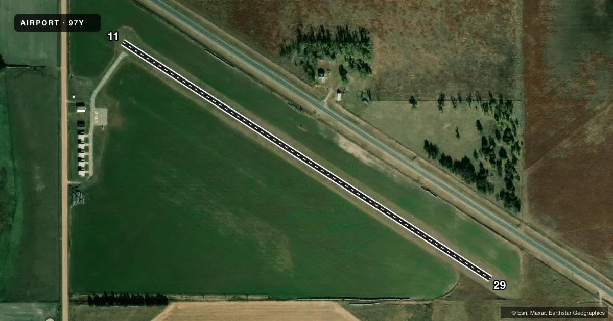
Airport sketch
Runways drawn to scale from FAA survey coordinates, rendered over satellite imagery. Not for navigation.
Approaches & charts
Services on the field
Fuel grades, oxygen, maintenance, ramp storage and lighting — as declared to the FAA by the airport operator.
Fuel & services
- Fuel
- 100LL
- Oxygen (bottled)
- Not available
- Oxygen (bulk)
- Not available
- Airframe repair
- Not available
- Power plant repair
- Not available
Ramp & ground
- Transient storage
- Tie-down
- Landing fee
- No fee published
- Wind indicator
- Yes
- Segmented circle
- No
Fuel & FBOs
Cheapest 100LL and Jet A on the field and nearby. Always confirm with the FBO before taxi.
Airport notes
Surface conditions, obstructions, local procedures, lighting outages and other notes published with each FAA cycle.
General notes
- FOR CD CTC MINNEAPOLIS ARTCC AT 651-463-5588.
- CNTR PIVOT IRRIGATION ARM MAY ROT INTO PRIM SFC SPRING THRU AUTUMN.
Fuel notes
- 100LLFOR FUEL CALL 402-270-5103.
VFR map & nearby airports
VFR sectional. Tap any ICAO chip to open that airport.
Key facts · 97Y
Answer card- ICAO
- 97Y
- Name
- GENOA MUNI
- Location
- GENOA, NEBRASKA
- Elevation
- 1,572 ft MSL
- Traffic pattern altitude
- 2,572 ft MSL (1,000 AGL)
- Control tower
- Non-towered (use CTAF)
- Total runways
- 1
- Longest runway
- 11/29 · 2,517 ft
- Published ILS approaches
- 0
- Published frequencies
- 2
- Magnetic variation
- 7°
- Current flight rules
- VFR
- Current wind
- 160° at 4 kt
- Favored runway now
- RWY 11
Genoa Muni sits in Genoa, Nebraska. The field elevation is 1,572 ft MSL. It has one runway, 11/29, which is 2,517 ft of turf. There is no control tower. CTAF and UNICOM are both 122.8. No ILS approaches are published here.
Pattern altitude is not published. Use the standard 1,000 ft AGL for light piston operations unless the current Chart Supplement says otherwise. That puts the working pattern at 2,572 ft MSL based on the listed field elevation. The on-field FBO is Genoa Municipal Airport. It carries 100LL. Call ahead at (402) 993-2324. The remarks also say to call 402-270-5103 for fuel. One operational item to watch is the center pivot irrigation arm. It may rotate into the primary surface from spring through autumn. Clearance delivery is handled through Minneapolis ARTCC at 651-463-5588. This is a small turf field with no tower, so plan for self-announced traffic and verify current conditions before you go. Check the current FAA Chart Supplement for any published noise or curfew restrictions before flying into the field.