METAR & TAF K59
K59 does not publish a METAR.
Showing the nearest reporting station: KSTJ (ROSECRANS MEML) · 17.4 NM away. Conditions at K59 may differ.
METAR · KSTJ
Observed 21:53Z
KSTJ 272153Z 27007KT 10SM CLR 36/26 A2977 RMK AO2 SLP070 T03610256
- Wind
- 270° @ 7 kt
- Visibility
- 10 SM
- Temp / Dew
- 36°C / 26°C
- Altimeter
- 29.77 inHg
- Clouds
- CLR
- Density alt
- 4,037 ft
- Ceiling
- Unlimited
- Rules
- VFR
Airport info & contacts
Manager on record, flight service, ARTCC, attendance schedule and pattern altitude — published by the FAA and refreshed every 28 days.
Location
- From city
- 2 NM W
- VFR sectional
- KANSAS CITY
- ARTCC
- ZKC · KANSAS CITY
- NOTAM facility
- ICT (NOTAM-D)
Airport manager
- Name
- CLINTON MCNEMEE
- Phone
- 913-426-0311
- Address
- 515 KANSAS AVE, ATCHISON KS 66002
Flight service · Hours
- FSS ICT
- WICHITA1-800-WX-BRIEF
- Attendance
- 0900-1900
Frequencies
Tap any row to copy the frequency to your clipboard.
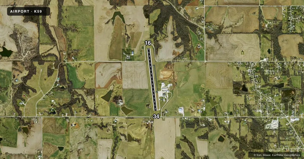
Runways & pattern
Full pagePattern entry · RWY 34
LEFT TRAFFICRunway end performance
| End | TORA | TODA | ASDA | LDA | VGSI | Approach lights | Obstruction |
|---|---|---|---|---|---|---|---|
| 16 | — | — | — | — | — | — | 60', trees, 1173' from thr, 279' R of cntrln, slope 16 |
| 34 | — | — | — | — | — | — | 15', road, 287' from thr, 0' R of cntrln, slope 5 |
Declared distances in feet. TORA = takeoff run available, TODA = takeoff distance, ASDA = accelerate-stop, LDA = landing distance.
Airport sketch
Runways drawn to scale from FAA survey coordinates, rendered over satellite imagery. Not for navigation.
Approaches & charts
Services on the field
Fuel grades, oxygen, maintenance, ramp storage and lighting — as declared to the FAA by the airport operator.
Fuel & services
- Fuel
- 100LLA+
- Other services
- AGRI
Ramp & ground
- Transient storage
- Tie-down
- Landing fee
- No fee published
- Customs
- Not available
- Lighting schedule
- SEE RMK
- Beacon schedule
- SS-SR
- Beacon
- White / Green (civil land)(WG)
- Wind indicator
- Lighted
- Segmented circle
- No
Fuel & FBOs
Cheapest 100LL and Jet A on the field and nearby. Always confirm with the FBO before taxi.
Airport notes
Surface conditions, obstructions, local procedures, lighting outages and other notes published with each FAA cycle.
General notes
- EXTSV AERIAL AG OPS.
- FOR CD CTC KANSAS CITY APCH AT 816-329-2710.
- AMELIA EARHART HANGAR MUSEUM ON ARPT - 913-372-0021.
Lighting notes
- ACTVT LIRL RWY 16/34 - CTAF.
Fuel notes
- A+FUEL 24 HR SELF-SERV.
Other notes
- THIS AIRPORT HAS BEEN SURVEYED BY THE NATIONAL GEODETIC SURVEY.
- MANAGERPUBLIC WORKS DIRECTOR/AMGR.
- MANAGERALT PH NUMBER 913-568-3819.
- OWNERINTERIM CITY MGR BECKY BERGER, ALTN CLINTON MCNEMEE 913-367-5561.
VFR map & nearby airports
VFR sectional. Tap any ICAO chip to open that airport.
Key facts · K59
Answer card- ICAO
- K59
- Name
- AMELIA EARHART
- Location
- ATCHISON, KANSAS
- Elevation
- 1,073 ft MSL
- Traffic pattern altitude
- 2,073 ft MSL (1,000 AGL)
- Control tower
- Non-towered (use CTAF)
- Total runways
- 1
- Longest runway
- 16/34 · 3,000 ft
- Published ILS approaches
- 0
- Published frequencies
- 6
- Magnetic variation
- 2°
- Current flight rules
- VFR
- Current wind
- 270° at 7 kt
- Favored runway now
- RWY 34
Amelia Earhart Airport sits in Atchison, Kansas. The field elevation is 1,073 ft MSL. It has one runway, 16/34, which is 3,000 ft long with asphalt pavement. There is no control tower. The pattern altitude is not published, so use the standard 1,000 ft AGL for light piston operations unless the current Chart Supplement says otherwise. No ILS approaches are published here.
This is a non-towered field with CTAF and UNICOM on 122.8. Low intensity runway lights on 16/34 are activated by the CTAF. Heartland AG Aviation is on the field. It carries 100LL and Jet A Prist. Fuel is available 24 hours self-service. Extensive aerial agricultural operations occur here, so expect ag traffic and stay sharp on the CTAF. For clearance delivery, contact Kansas City Approach. The airport is in Atchison, so watch density altitude on warm days and plan for a short runway if you are bringing in a heavier airplane. The Amelia Earhart Hangar Museum is also on the airport.