METAR & TAF KFNB
Current METAR
Observed 17:53Z
KFNB 121753Z AUTO VRB04KT 10SM CLR 27/12 A3003 RMK AO2 SLP161 T02670122 10267 20144 56005
- Wind
- VAR @ 4 kt
- Visibility
- 10 SM
- Temp / Dew
- 27°C / 12°C
- Altimeter
- 30.03 inHg
- Clouds
- CLR
- Density alt
- 2,524 ft
- Ceiling
- Unlimited
- Rules
- VFR
Airport info & contacts
Manager on record, flight service, ARTCC, attendance schedule and pattern altitude — published by the FAA and refreshed every 28 days.
Location
- From city
- 1 NM NE
- VFR sectional
- OMAHA
- ARTCC
- ZKC · KANSAS CITY
- NOTAM facility
- FNB (NOTAM-D)
Airport manager
- Name
- BRAD AHERN
- Phone
- 402-245-3715
- Address
- 3301 BUSINESS PARKWAY NORTH, FALLS CITY NE 68355-1963
Flight service · Hours
- FSS OLU
- COLUMBUS1-800-WX-BRIEF
- Attendance
- 0800-1700
Frequencies
Tap any row to copy the frequency to your clipboard.
Runways & pattern
Full pagePattern entry · RWY 33
LEFT TRAFFICRunway end performance
| End | TORA | TODA | ASDA | LDA | VGSI | Approach lights | Obstruction |
|---|---|---|---|---|---|---|---|
| 15 | — | — | — | — | PAPI 2-box left(3°) | — | — |
| 33 | — | — | — | — | PAPI 2-box left(3°) | — | — |
Declared distances in feet. TORA = takeoff run available, TODA = takeoff distance, ASDA = accelerate-stop, LDA = landing distance.
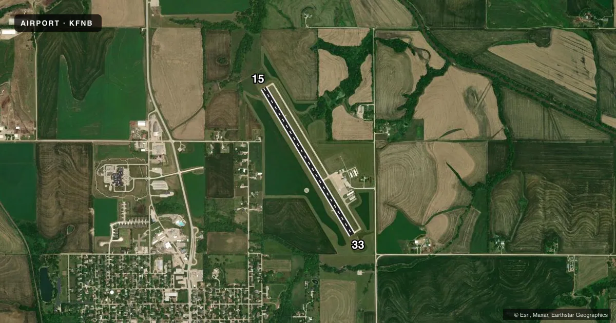
Airport sketch
Runways drawn to scale from FAA survey coordinates, rendered over satellite imagery. Not for navigation.
Approaches & charts
Services on the field
Fuel grades, oxygen, maintenance, ramp storage and lighting — as declared to the FAA by the airport operator.
Fuel & services
- Fuel
- 100LLA
- Oxygen (bottled)
- Not available
- Oxygen (bulk)
- Not available
- Airframe repair
- Major
- Power plant repair
- Major
- Other services
- AGRI
Ramp & ground
- Transient storage
- Tie-down
- Hangar
- Landing fee
- No fee published
- Customs
- Not available
- Lighting schedule
- SEE RMK
- Beacon schedule
- SS-SR
- Beacon
- White / Green (civil land)(WG)
- Wind indicator
- Lighted
- Segmented circle
- Yes
Fuel & FBOs
Cheapest 100LL and Jet A on the field and nearby. Always confirm with the FBO before taxi.
Airport notes
Surface conditions, obstructions, local procedures, lighting outages and other notes published with each FAA cycle.
General notes
- FOR CD CTC ST JOSEPH APCH AT 816-236-3035. WHEN ST JOSEPH APCH IS CLSD, CTC KANSAS CITY ARTCC AT 913-254-8508.
- TWO COURTESY CARS AVBL.
Lighting notes
- ACTVT MIRL RY 15/33; PAPI RY 15/33 AND REIL RY 15 & 33 - CTAF.
- ULTRALIGHT ACTIVITY ON & INVOF ARPT.
Fuel notes
- 100LL24 HR CREDIT CARD FUELING
Other notes
- CALL ARPT MGR TO ARNG TRANSIENT HANGAR RENTAL 402-245-3715.
- 1FOR SVC AFT HRS CALL 402-245-3715 OR 402-245-7313.
VFR map & nearby airports
VFR sectional. Tap any ICAO chip to open that airport.
Key facts · KFNB
Answer card- ICAO
- KFNB
- Name
- BRENNER FLD
- Location
- FALLS CITY, NEBRASKA
- Elevation
- 983.9 ft MSL
- Traffic pattern altitude
- 1,983.9 ft MSL (1,000 AGL)
- Control tower
- Non-towered (use CTAF)
- Total runways
- 1
- Longest runway
- 15/33 · 4,000 ft
- Published ILS approaches
- 0
- Published frequencies
- 4
- Magnetic variation
- 3°
- Current flight rules
- VFR
- Current wind
- 000° at 4 kt
- Favored runway now
- RWY 33
Brenner Fld is in Falls City, Nebraska. The field elevation is 983.9 ft MSL. It has one runway, 15/33. The longest runway is 4,000 ft of concrete. There is no control tower. Pattern altitude is not published, so use the standard 1,000 ft AGL for light piston operations unless the current Chart Supplement says otherwise.
No ILS approaches are published here. The airport uses CTAF 122.8. St Joseph Approach handles approach and departure work on 120.35 and 360.8. For clearance delivery, contact St Joseph Approach. If they are closed, Kansas City Center takes over. Ahern Aviation is on the field. It carries 100LL and Jet A. 24-hour credit card fueling is available. After hours service is available by phone.
The published remarks matter here. Runway 15 has a tree-related obstacle note off the departure end, so plan your climb and departure path carefully. Medium intensity runway lights are installed on 15/33. PAPI is available on runway 15. Ultralight activity also occurs on and near the airport, so keep a sharp scan in the pattern and on final. If you need transient hangar space, call the airport manager ahead of time.