METAR & TAF K88
Current METAR
Observed 06:35Z
KK88 130635Z AUTO VRB04KT 2 1/2SM HZ BKN050 OVC065 24/21 A2993 RMK AO2 VIS 1 3/4V5
- Wind
- VAR @ 4 kt
- Visibility
- 0.5 SM
- Temp / Dew
- 24°C / 21°C
- Altimeter
- 29.93 inHg
- Clouds
- OVC
- Density alt
- 2,327 ft
- Ceiling
- 5,000 ft AGL
- Rules
- LIFR
Airport info & contacts
Manager on record, flight service, ARTCC, attendance schedule and pattern altitude — published by the FAA and refreshed every 28 days.
Location
- From city
- 3 NM SE
- VFR sectional
- KANSAS CITY
- ARTCC
- ZKC · KANSAS CITY
- NOTAM facility
- ICT (NOTAM-D)
Airport manager
- Name
- ROBERT POYDACK
- Phone
- 620-212-1316
- Address
- 1705 MINNESOTA RD, IOLA KS 66749
Flight service · Hours
- FSS ICT
- WICHITA1-800-WX-BRIEF
- Attendance
- MON-FRI · 0730-1600
Frequencies
Tap any row to copy the frequency to your clipboard.
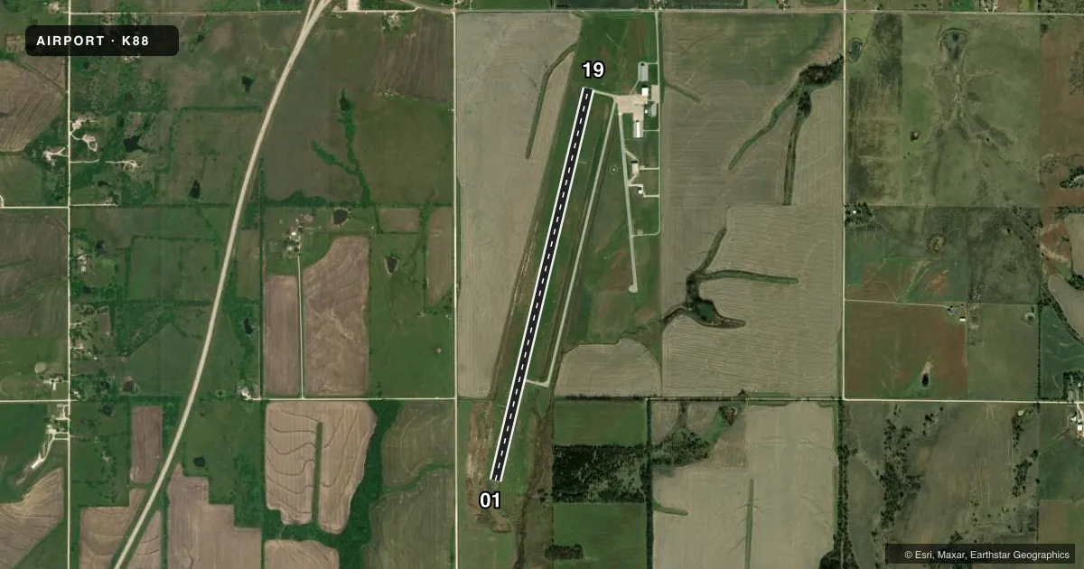
Runways & pattern
Full pagePattern entry · RWY 01
LEFT TRAFFICRunway end performance
| End | TORA | TODA | ASDA | LDA | VGSI | Approach lights | Obstruction |
|---|---|---|---|---|---|---|---|
| 01 | — | — | — | — | PAPI 4-box left(3°) | — | 42', pole, 1330' from thr, 0' R of cntrln, slope 26 |
| 19 | — | — | — | — | PAPI 4-box left(3°) | — | 33', tree, 1180' from thr, 200' R of cntrln, slope 29 |
Declared distances in feet. TORA = takeoff run available, TODA = takeoff distance, ASDA = accelerate-stop, LDA = landing distance.
Airport sketch
Runways drawn to scale from FAA survey coordinates, rendered over satellite imagery. Not for navigation.
Approaches & charts
Services on the field
Fuel grades, oxygen, maintenance, ramp storage and lighting — as declared to the FAA by the airport operator.
Fuel & services
- Fuel
- 100LLAMOGAS
- Oxygen (bottled)
- Not available
- Oxygen (bulk)
- Not available
- Airframe repair
- Major
- Power plant repair
- Major
- Other services
- INSTR
Ramp & ground
- Transient storage
- Tie-down
- Hangar
- Landing fee
- No fee published
- Customs
- Not available
- Lighting schedule
- SEE RMK
- Beacon schedule
- SS-SR
- Beacon
- White / Green (civil land)(WG)
- Wind indicator
- Lighted
- Segmented circle
- Yes
Fuel & FBOs
Cheapest 100LL and Jet A on the field and nearby. Always confirm with the FBO before taxi.
Airport notes
Surface conditions, obstructions, local procedures, lighting outages and other notes published with each FAA cycle.
General notes
- COURTESY CAR AVBL.
- WILDLIFE ON & INVOF AIRPORT.
- FOR CD CTC KANSAS CITY ARTCC AT 913-254-8508.
Lighting notes
- ACTVT REIL RWY 01 & 19; PAPI RWYS 01 & 19; MIRL RWY 01/19 - CTAF.
VFR map & nearby airports
VFR sectional. Tap any ICAO chip to open that airport.
Key facts · K88
Answer card- ICAO
- K88
- Name
- ALLEN COUNTY
- Location
- IOLA, KANSAS
- Elevation
- 1,015.6 ft MSL
- Traffic pattern altitude
- 2,015.6 ft MSL (1,000 AGL)
- Control tower
- Non-towered (use CTAF)
- Total runways
- 1
- Longest runway
- 01/19 · 5,501 ft
- Published ILS approaches
- 0
- Published frequencies
- 2
- Magnetic variation
- 4°
- Current flight rules
- LIFR
- Current wind
- 000° at 4 kt
- Favored runway now
- RWY 01
Allen County Airport sits in Iola, Kansas. The field elevation is 1,015.6 ft MSL. It has one runway. Runway 01/19 is 5,501 ft long with a concrete surface. There is no control tower. CTAF and UNICOM are both 122.8. No ILS approaches are published here.
The pattern altitude is not published in the facts. For a light piston, use the standard 1,000 ft AGL unless the current Chart Supplement says otherwise. The on-field FBO is Allen County Airport. It carries 100LL, Jet A and mogas. Courtesy car service is available. Wildlife has been reported on and near the airport. Keep a sharp scan on taxi, takeoff and landing.
Runway lighting is pilot-controlled on 01/19. Runway end identifier lights are active on both ends. Precision approach path indicators are installed on both ends as well. For IFR clearance delivery, contact Kansas City Air Route Traffic Control Center at 913-254-8508 before departure. If you need current noise, curfew, or local operating guidance, check the current FAA Chart Supplement or call the airport operator directly before you go.