METAR & TAF KOWI
Current METAR
Observed 22:15Z
KOWI 272215Z AUTO 20010KT 10SM CLR 38/23 A2977 RMK A01
- Wind
- 200° @ 10 kt
- Visibility
- 10 SM
- Temp / Dew
- 38°C / 23°C
- Altimeter
- 29.77 inHg
- Clouds
- CLR
- Density alt
- 4,144 ft
- Ceiling
- Unlimited
- Rules
- VFR
Airport info & contacts
Manager on record, flight service, ARTCC, attendance schedule and pattern altitude — published by the FAA and refreshed every 28 days.
Location
- From city
- 4 NM S
- VFR sectional
- KANSAS CITY
- ARTCC
- ZKC · KANSAS CITY
- NOTAM facility
- ICT (NOTAM-D)
Airport manager
- Name
- JIM REEDER
- Phone
- 785-242-5310
- Address
- 2178 MONTANA RD, OTTAWA KS 66067
Flight service · Hours
- FSS ICT
- WICHITA1-800-WX-BRIEF
- Attendance
- TUES - SAT · 0800 - 1400
Frequencies
Tap any row to copy the frequency to your clipboard.
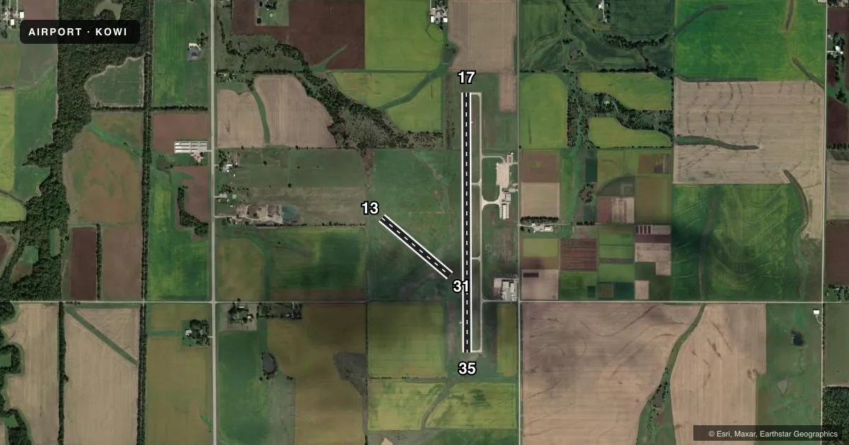
Runways & pattern
Full pagePattern entry · RWY 17
RIGHT TRAFFIC| Runway | Heading (°M) | Length | Surface | Traffic |
|---|---|---|---|---|
| 17/35Favored | 176° / 356° | 4,500 ft | CONC | 17 R |
| 13/31 | 127° / 307° | 1,550 ft | TURF | 13 R |
Runway end performance
| End | TORA | TODA | ASDA | LDA | VGSI | Approach lights | Obstruction |
|---|---|---|---|---|---|---|---|
| 17 | — | — | — | — | PAPI 2-box left(3.25°) | — | 65', tree, 1171' from thr, 462' R of cntrln, slope 14 |
| 35 | — | — | — | — | PAPI 2-box left(3.25°) | — | — |
| 13 | — | — | — | — | — | — | 22', tree, 778' from thr, 21' R of cntrln, slope 35 |
| 31 | — | — | — | — | — | — | 44', pole, 1089' from thr, 11' R of cntrln, slope 24 |
Declared distances in feet. TORA = takeoff run available, TODA = takeoff distance, ASDA = accelerate-stop, LDA = landing distance.
Airport sketch
Runways drawn to scale from FAA survey coordinates, rendered over satellite imagery. Not for navigation.
Approaches & charts
Services on the field
Fuel grades, oxygen, maintenance, ramp storage and lighting — as declared to the FAA by the airport operator.
Fuel & services
- Fuel
- 100LLA
- Oxygen (bottled)
- Not available
- Oxygen (bulk)
- Not available
- Airframe repair
- Not available
- Power plant repair
- Not available
- Other services
- GLD,INSTR,SALES,SURV
Ramp & ground
- Transient storage
- Tie-down
- Hangar
- Landing fee
- No fee published
- Customs
- Not available
- Lighting schedule
- SEE RMK
- Beacon schedule
- SS-SR
- Beacon
- White / Green (civil land)(WG)
- Wind indicator
- Lighted
- Segmented circle
- Yes
Fuel & FBOs
Cheapest 100LL and Jet A on the field and nearby. Always confirm with the FBO before taxi.
Airport notes
Surface conditions, obstructions, local procedures, lighting outages and other notes published with each FAA cycle.
General notes
- WILDLIFE ON & INVOF ARPT
- ULTRALIGHT ACTIVITY ON & INVOF ARPT.
- FBO SVCS NOT AVBL EASTER, THANKSGIVING AND CHRISTMAS DAY.
- 75 FT POLES 1700 FT N OF AER 17 MKD W/RED LGTS. PLINE MKD W/RED BALLS.
- FOR CD CTC KANSAS CITY ARTCC AT 913-254-8508.
- TWY AND HOLD LINE MKGS POOR.
Lighting notes
- ACTVT REILS RWY 17 & 35; PAPI RWY 17 & 35 - CTAF. MIRL RWY 17/35 PRESET ON LOW INTST TO INCR INTST - CTAF.
Approach & departure obstructions
- 13RWY 13/31 MKD WITH WHITE BUCKETS.
Other notes
- MANAGERAMGR CELL 785-418-5271.
VFR map & nearby airports
VFR sectional. Tap any ICAO chip to open that airport.
Key facts · KOWI
Answer card- ICAO
- KOWI
- Name
- OTTAWA MUNI
- Location
- OTTAWA, KANSAS
- Elevation
- 966.4 ft MSL
- Traffic pattern altitude
- 1,966.4 ft MSL (1,000 AGL)
- Control tower
- Non-towered (use CTAF)
- Total runways
- 2
- Longest runway
- 17/35 · 4,500 ft
- Published ILS approaches
- 0
- Published frequencies
- 2
- Magnetic variation
- 4°
- Current flight rules
- VFR
- Current wind
- 200° at 10 kt
- Favored runway now
- RWY 17
Ottawa Muni is in Ottawa, Kansas. The field elevation is 966.4 ft MSL. It has two runways. The longest is runway 17/35 at 4,500 ft of concrete. Runway 13/31 is 1,550 ft of turf. There is no control tower. CTAF and UNICOM are both 122.8.
No ILS approaches are published here. Pattern altitude is not published, so use the standard 1,000 ft AGL for light piston traffic unless the current Chart Supplement says otherwise. The on-field FBO is Ottawa Municipal Airport. It carries 100LL and Jet A. Call (785) 242-5310 before you go if you need current services. Published remarks also note runway end identifier lights on 17 and 35. PAPI is controlled by CTAF on those runways. The medium intensity lights on 17/35 start at low intensity and can be increased by CTAF.
A first-time pilot should pay attention to the local hazards. There are 75-foot poles north of the airport near runway 17. Power lines are marked with red balls. Wildlife has been reported on and near the field. Taxiway and hold line markings are poor. Ultralight activity is also present. If you need clearance delivery, contact Kansas City ARTCC at 913-254-8508. Check the current Chart Supplement for any published noise or curfew restrictions before flying into the field.