METAR & TAF 3JA
3JA does not publish a METAR.
Showing the nearest reporting station: KCNU (CHANUTE MARTIN JOHNSON) · 16.7 NM away. Conditions at 3JA may differ.
METAR · KCNU
Observed 21:52Z
KCNU 272152Z AUTO 19015G20KT 10SM CLR 38/21 A2982 RMK AO2 PK WND 18030/2107 SLP081 T03780206
- Wind
- 190° @ 15G20 kt
- Visibility
- 10 SM
- Temp / Dew
- 38°C / 21°C
- Altimeter
- 29.82 inHg
- Clouds
- CLR
- Density alt
- 4,283 ft
- Ceiling
- Unlimited
- Rules
- VFR
Airport info & contacts
Manager on record, flight service, ARTCC, attendance schedule and pattern altitude — published by the FAA and refreshed every 28 days.
Location
- From city
- 2 NM SSW
- VFR sectional
- KANSAS CITY
- ARTCC
- ZKC · KANSAS CITY
- NOTAM facility
- ICT
Airport manager
- Name
- CITY OF YATES CENTER
- Phone
- 210-876-0000
- Address
- 117 E. RUTLEDGE, YATES CENTER KS 66783
Flight service · Hours
- FSS ICT
- WICHITA1-800-WX-BRIEF
Frequencies
Tap any row to copy the frequency to your clipboard.
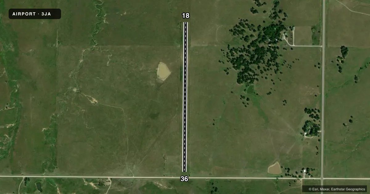
Runways & pattern
Full pagePattern entry · RWY 18
RIGHT TRAFFICAirport sketch
Runways drawn to scale from FAA survey coordinates, rendered over satellite imagery. Not for navigation.
Approaches & charts
Services on the field
Fuel grades, oxygen, maintenance, ramp storage and lighting — as declared to the FAA by the airport operator.
Fuel & services
- Fuel
- Not available
Ramp & ground
- Transient storage
- Not published
Fuel & FBOs
Cheapest 100LL and Jet A on the field and nearby. Always confirm with the FBO before taxi.
Airport notes
Surface conditions, obstructions, local procedures, lighting outages and other notes published with each FAA cycle.
Other notes
- MANAGERJATKIN@CITYOFYATESCENTER.COM
VFR map & nearby airports
VFR sectional. Tap any ICAO chip to open that airport.
Key facts · 3JA
Answer card- ICAO
- 3JA
- Name
- YATES CENTER MUNI
- Location
- YATES CENTER, KANSAS
- Elevation
- 1,128 ft MSL
- Traffic pattern altitude
- 2,128 ft MSL (1,000 AGL)
- Control tower
- Non-towered (use CTAF)
- Total runways
- 1
- Longest runway
- 18/36 · 3,000 ft
- Published ILS approaches
- 0
- Published frequencies
- 1
- Magnetic variation
- –
- Current flight rules
- VFR
- Current wind
- 190° at 15 kt
- Favored runway now
- RWY 18
Yates Center Muni sits in Yates Center, Kansas. Field elevation is 1,128 ft MSL. The airport has one runway. Runway 18/36 is a 3,000 ft turf strip. There is no control tower. CTAF is 122.9. No ILS approaches are published here.
Pattern altitude is not published. Use the standard 1,000 ft AGL pattern unless local guidance says otherwise. That puts the traffic pattern at about 2,128 ft MSL based on field elevation. Verify the current Chart Supplement before you go. The airport manager can be contacted at jatkin@cityofyatescenter.com.
There are no on-field FBOs listed in the facts. Plan on checking with the airport operator or the field directly for current services before arrival. For a first-time arrival, the main things to plan for are the turf surface, the lack of tower control and the need to self-announce clearly on CTAF. With no published ILS, this is a VFR-minded stop unless you have current approach data from the FAA Chart Supplement. Magnetic variation is unknown in the provided facts. Use the published runway numbers as charted.