METAR & TAF KCNU
Current METAR
Observed 17:52Z
KCNU 271752Z AUTO 20010G20KT 10SM CLR 36/21 A2987 RMK AO2 SLP099 T03610211 10361 20261 58010
- Wind
- 200° @ 10G20 kt
- Visibility
- 10 SM
- Temp / Dew
- 36°C / 21°C
- Altimeter
- 29.87 inHg
- Clouds
- CLR
- Density alt
- 3,825 ft
- Ceiling
- Unlimited
- Rules
- VFR
Airport info & contacts
Manager on record, flight service, ARTCC, attendance schedule and pattern altitude — published by the FAA and refreshed every 28 days.
Location
- From city
- 2 NM SW
- VFR sectional
- KANSAS CITY
- ARTCC
- ZKC · KANSAS CITY
- NOTAM facility
- CNU (NOTAM-D)
Airport manager
- Name
- RYAN FOLMER
- Phone
- 620-305-9689
- Address
- 800 S. COUNTRY CLUB ROAD, CHANUTE KS 66720
Flight service · Hours
- FSS ICT
- WICHITA1-800-WX-BRIEF
- Attendance
- MON-SAT · 0800-1700
- SUN · 1200-1700
Frequencies
Tap any row to copy the frequency to your clipboard.
Runways & pattern
Full pagePattern entry · RWY 18
LEFT TRAFFICRunway end performance
| End | TORA | TODA | ASDA | LDA | VGSI | Approach lights | Obstruction |
|---|---|---|---|---|---|---|---|
| 18 | — | — | — | — | PAPI 2-box left(3°) | — | 48', tree, 693' from thr, 190' R of cntrln, slope 10 |
| 36 | — | — | — | — | PAPI 2-box left(3°) | — | 23', rr, 270' from thr, 0' R of cntrln, slope 3 |
Declared distances in feet. TORA = takeoff run available, TODA = takeoff distance, ASDA = accelerate-stop, LDA = landing distance.
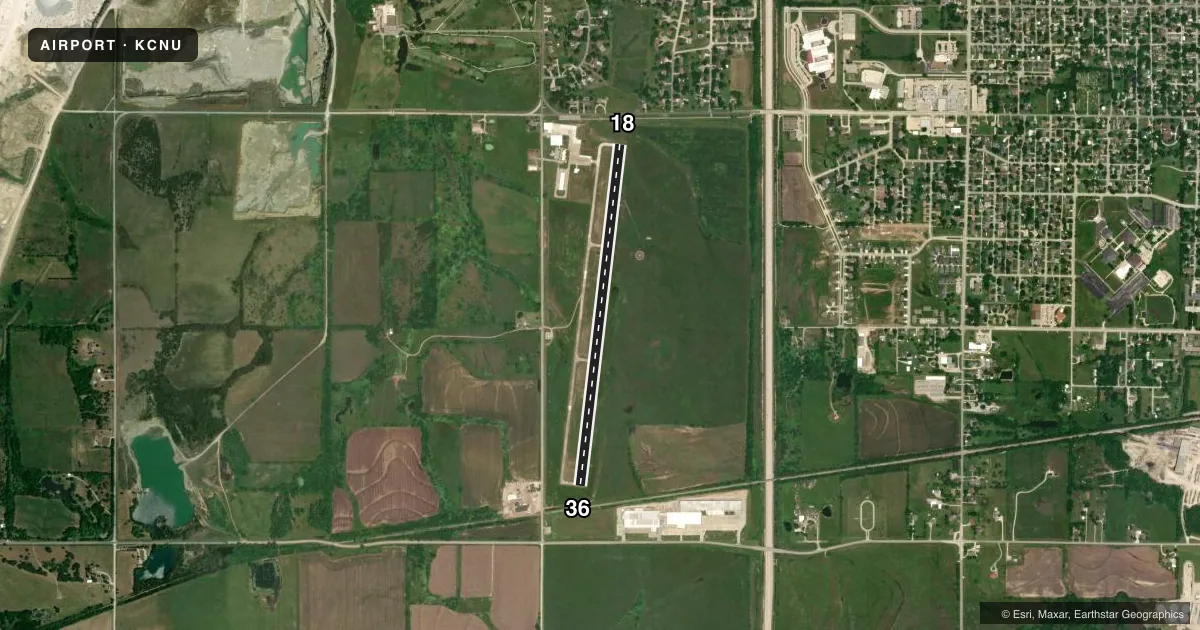
Airport sketch
Runways drawn to scale from FAA survey coordinates, rendered over satellite imagery. Not for navigation.
Approaches & charts
Services on the field
Fuel grades, oxygen, maintenance, ramp storage and lighting — as declared to the FAA by the airport operator.
Fuel & services
- Fuel
- 100LLA
- Oxygen (bottled)
- Not available
- Oxygen (bulk)
- Not available
- Airframe repair
- Not available
- Power plant repair
- Not available
- Other services
- AGRI,AMB
Ramp & ground
- Transient storage
- Tie-down
- Hangar
- Landing fee
- No fee published
- Customs
- Not available
- Lighting schedule
- SEE RMK
- Beacon schedule
- SEE RMK
- Beacon
- White / Green (civil land)(WG)
- Wind indicator
- Lighted
- Segmented circle
- Yes
Fuel & FBOs
Cheapest 100LL and Jet A on the field and nearby. Always confirm with the FBO before taxi.
Airport notes
Surface conditions, obstructions, local procedures, lighting outages and other notes published with each FAA cycle.
General notes
- ULTRALIGHT ACTV, BIRDS & WILDLIFE ON & INVOF ARPT.
- COURTSEY CAR AVBL.
- FOR CD IF UNA TO CTC ON FSS FREQ, CTC KANSAS CITY ARTCC AT 913-254-8508.
Lighting notes
- DUSK-2300
- ACTVT REIL RWY 18 & 36; PAPI RWY 18 & 36; MIRL RWY 18/36 - CTAF.
Approach & departure obstructions
- 18+25 FT TREE 173 FRM AER 18, 190 FT L OF CL.
- 36APCH RATIO 32:1 FROM DSPLCD THR.
Other notes
- PRVDD CLEAR 20:1 APCH & 7:1 TRANSITIONAL SFC.
- 1FOR AFT HRS EMERG CALL (620) 305-9689.
VFR map & nearby airports
VFR sectional. Tap any ICAO chip to open that airport.
Key facts · KCNU
Answer card- ICAO
- KCNU
- Name
- CHANUTE MARTIN JOHNSON
- Location
- CHANUTE, KANSAS
- Elevation
- 1,002.5 ft MSL
- Traffic pattern altitude
- 2,002.5 ft MSL (1,000 AGL)
- Control tower
- Non-towered (use CTAF)
- Total runways
- 1
- Longest runway
- 18/36 · 4,254 ft
- Published ILS approaches
- 0
- Published frequencies
- 2
- Magnetic variation
- 1°
- Current flight rules
- VFR
- Current wind
- 200° at 10 kt
- Favored runway now
- RWY 18
Chanute Martin Johnson Airport sits in Chanute, Kansas. Field elevation is 1,002.5 ft MSL. The airport has one runway. Runway 18/36 is 4,254 ft of asphalt. There is no control tower. CTAF and UNICOM are both 122.7. No ILS approaches are published here.
Pattern altitude is not published. For a light piston, use the standard 1,000 ft AGL pattern unless the current Chart Supplement or local procedures say otherwise. The field uses magnetic headings of 187° for runway 18 and 7° for runway 36. The beacon operates from dusk until 2300. Runway end identifier lights are available on both ends. PAPI is available for runway 18 and runway 36. Medium intensity runway lights are controlled by CTAF.
The on-field FBO is Chanute Martin Johnson Airport. It carries AVGAS 100LL and Jet A. Call (620) 431-5296 for current service details. First-time arrivals should watch for ultralights, birds and wildlife in the area. There is also a 25-foot tree near the approach end of runway 18. If you need clearance delivery after hours or cannot reach Flight Service, the published remark points pilots to Kansas City Center. A courtesy car is available. For after-hours emergencies, use the number in the current Chart Supplement.