METAR & TAF KPPF
Current METAR
Observed 19:52Z
KPPF 271952Z AUTO 21012KT 10SM CLR 37/21 A2984 RMK AO2 SLP090 T03720206
- Wind
- 210° @ 12 kt
- Visibility
- 10 SM
- Temp / Dew
- 37°C / 21°C
- Altimeter
- 29.84 inHg
- Clouds
- CLR
- Density alt
- 3,856 ft
- Ceiling
- Unlimited
- Rules
- VFR
Airport info & contacts
Manager on record, flight service, ARTCC, attendance schedule and pattern altitude — published by the FAA and refreshed every 28 days.
Location
- From city
- 11 NM W
- VFR sectional
- KANSAS CITY
- ARTCC
- ZKC · KANSAS CITY
- NOTAM facility
- PPF (NOTAM-D)
Airport manager
- Name
- DYLAN VITT
- Phone
- 620-336-3440
- Address
- 163 24000 RD, CHERRYVALE KS 67335
Flight service · Hours
- FSS ICT
- WICHITA1-800-WX-BRIEF
- Attendance
- MON-FRI · 0800-1700
Frequencies
Tap any row to copy the frequency to your clipboard.
Runways & pattern
Full pagePattern entry · RWY 17
LEFT TRAFFICRunway end performance
| End | TORA | TODA | ASDA | LDA | VGSI | Approach lights | Obstruction |
|---|---|---|---|---|---|---|---|
| 17 | — | — | — | — | VASI 4-box left(3°) | — | 70', tree, 1680' from thr, 175' R of cntrln, slope 21 |
| 35 | — | — | — | — | VASI 4-box left(3°) | — | 250', trees, 20' from thr, 230' R of cntrln, slope 0 |
Declared distances in feet. TORA = takeoff run available, TODA = takeoff distance, ASDA = accelerate-stop, LDA = landing distance.
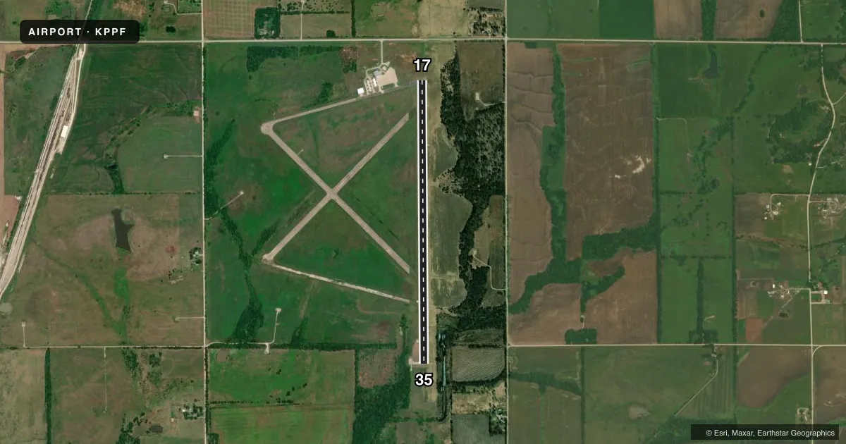
Airport sketch
Runways drawn to scale from FAA survey coordinates, rendered over satellite imagery. Not for navigation.
Approaches & charts
Services on the field
Fuel grades, oxygen, maintenance, ramp storage and lighting — as declared to the FAA by the airport operator.
Fuel & services
- Fuel
- 100LLAA+
- Oxygen (bottled)
- Not available
- Oxygen (bulk)
- Not available
- Airframe repair
- Not available
- Power plant repair
- Not available
Ramp & ground
- Transient storage
- Tie-down
- Hangar
- Landing fee
- No fee published
- Customs
- Not available
- Lighting schedule
- SEE RMK
- Beacon schedule
- SS-SR
- Beacon
- White / Green (civil land)(WG)
- Wind indicator
- Lighted
- Segmented circle
- No
Fuel & FBOs
Cheapest 100LL and Jet A on the field and nearby. Always confirm with the FBO before taxi.
Airport notes
Surface conditions, obstructions, local procedures, lighting outages and other notes published with each FAA cycle.
General notes
- WILDLIFE ON & INVOF RWYS.
- WKENDS AND HOLS, CALL OUT, NO CHARGE.
- FOR CD IF UNA TO CTC ON FSS FREQ, CTC KANSAS CITY ARTCC AT 913-254-8508.
Lighting notes
- ACTVT VASI AND REIL RWYS 17 & 35 - CTAF. MIRL RWY 17/35 OPER DUSK-2300; AFT 2300 ACTVT - CTAF.
Fuel notes
- 100LL24 HR SELF-SERVE 100LL FUEL.
Approach & departure obstructions
- 3535 FT TREES, 40-199 FT DSTC, 237 FT L.
- 17CONTROLLING OBSTN EXCEEDS A 45 DEG SLP.
Other notes
- PRVDD APCHS TO RWY 17-35 ARE MAINTD FOR A MIN 34:1 GLIDE SLOPE & THE TRSNL SFC MAINTD FOR A 7:1 SLOPE.
VFR map & nearby airports
VFR sectional. Tap any ICAO chip to open that airport.
Key facts · KPPF
Answer card- ICAO
- KPPF
- Name
- TRI-CITY
- Location
- PARSONS, KANSAS
- Elevation
- 900.5 ft MSL
- Traffic pattern altitude
- 1,900.5 ft MSL (1,000 AGL)
- Control tower
- Non-towered (use CTAF)
- Total runways
- 1
- Longest runway
- 17/35 · 5,001 ft
- Published ILS approaches
- 0
- Published frequencies
- 2
- Magnetic variation
- 6°
- Current flight rules
- VFR
- Current wind
- 210° at 12 kt
- Favored runway now
- RWY 17
Tri-City Airport sits in Parsons, Kansas. Field elevation is 900.5 ft MSL. The airport has one runway. Runway 17/35 is 5,001 ft long with a concrete surface. There is no control tower. CTAF and UNICOM are both 123.0.
No ILS approaches are published here. The published pattern altitude is not listed, so use the current Chart Supplement before you go. The field has VASI and REIL lighting on runway 17/35. Those lights are activated by CTAF. Medium intensity runway lights on 17/35 run from dusk to 2300. After 2300, activation is by CTAF.
Parsons Tri-City Airport has one on-field FBO. Parsons Tri-City Airport carries AVGAS 100LL and JET A. Twenty-four hour self-serve 100LL is available. On weekends and holidays, call out is required with no charge. Wildlife is present on and near the runways, so keep a sharp scan on taxi and final. Runway 35 has trees 40 to 199 ft from the runway edge, 237 ft left of centerline. Runway 17 also has a controlling obstruction that exceeds a 45 degree slope. This is a non-towered field with light local traffic. Plan your arrival with the current Chart Supplement and be ready to self-announce clearly on 123.0.