METAR & TAF 1KS
1KS does not publish a METAR.
Showing the nearest reporting station: KFSK (FORT SCOTT MUNI) · 22.8 NM away. Conditions at 1KS may differ.
METAR · KFSK
Observed 13:15Z
KFSK 271315Z AUTO 21012KT 10SM CLR 29/21 A2992 RMK AO2 T02870212
- Wind
- 210° @ 12 kt
- Visibility
- 10 SM
- Temp / Dew
- 29°C / 21°C
- Altimeter
- 29.92 inHg
- Clouds
- CLR
- Density alt
- 2,746 ft
- Ceiling
- Unlimited
- Rules
- VFR
Airport info & contacts
Manager on record, flight service, ARTCC, attendance schedule and pattern altitude — published by the FAA and refreshed every 28 days.
Location
- From city
- 1 NM E
- VFR sectional
- KANSAS CITY
- ARTCC
- ZKC · KANSAS CITY
- NOTAM facility
- ICT (NOTAM-D)
Airport manager
- Name
- DANIELLE SOUZA
- Phone
- 913-795-2274
- Address
- 315 S MAIN STREET, P O BOX 350, MOUND CITY KS 66056
Flight service · Hours
- FSS ICT
- WICHITA1-800-WX-BRIEF
- Attendance
- Unattended
Frequencies
Tap any row to copy the frequency to your clipboard.
Runways & pattern
Full pagePattern entry · RWY 18
RIGHT TRAFFICRunway end performance
| End | TORA | TODA | ASDA | LDA | VGSI | Approach lights | Obstruction |
|---|---|---|---|---|---|---|---|
| 18 | — | — | — | — | — | — | 38', tree, 1122' from thr, 80' R of cntrln, slope 24 |
| 36 | — | — | — | — | — | — | 33', trees, 658' from thr, 143' R of cntrln, slope 13 |
Declared distances in feet. TORA = takeoff run available, TODA = takeoff distance, ASDA = accelerate-stop, LDA = landing distance.
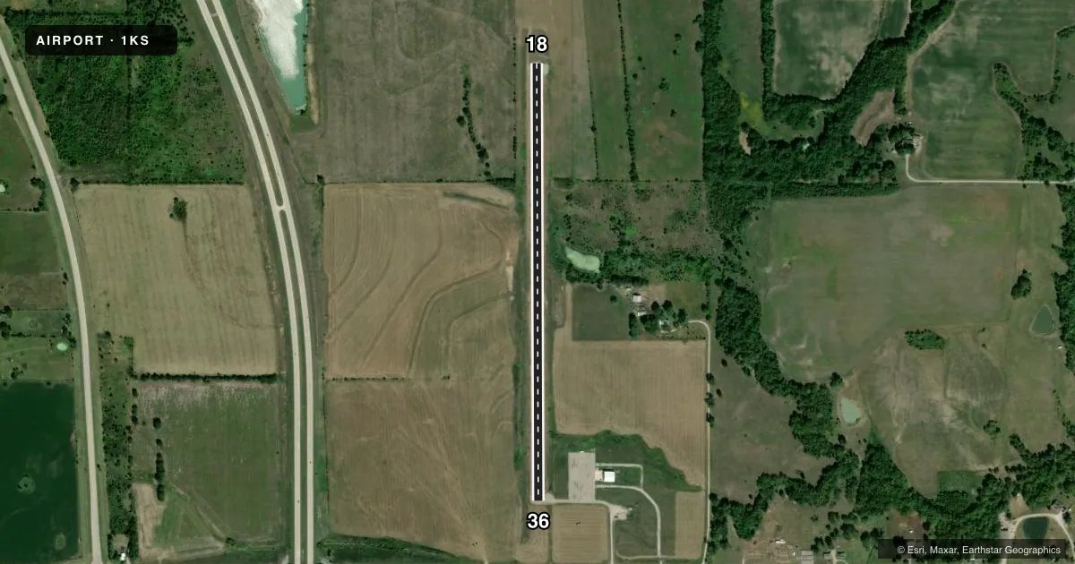
Airport sketch
Runways drawn to scale from FAA survey coordinates, rendered over satellite imagery. Not for navigation.
Approaches & charts
Services on the field
Fuel grades, oxygen, maintenance, ramp storage and lighting — as declared to the FAA by the airport operator.
Fuel & services
- Fuel
- Not available
Ramp & ground
- Transient storage
- Tie-down
- Landing fee
- No fee published
- Wind indicator
- Lighted
- Segmented circle
- No
Fuel & FBOs
Cheapest 100LL and Jet A on the field and nearby. Always confirm with the FBO before taxi.
Airport notes
Surface conditions, obstructions, local procedures, lighting outages and other notes published with each FAA cycle.
General notes
- WILDLIFE ON AND INVOF RUNWAY
- FOR CD CTC KANSAS CITY ARTCC AT 913-254-8508.
Other notes
- SUPPLY OWN ROPES FOR TIE DOWNS
- MANAGERARPT PHYS ADDR 22380 E 1000 TH ST PLEASANTON KS.600675
- MANAGERCOUNTY CLERK/INTERIM AMGR.
VFR map & nearby airports
VFR sectional. Tap any ICAO chip to open that airport.
Key facts · 1KS
Answer card- ICAO
- 1KS
- Name
- LINN COUNTY
- Location
- PLEASANTON, KANSAS
- Elevation
- 860 ft MSL
- Traffic pattern altitude
- 1,860 ft MSL (1,000 AGL)
- Control tower
- Non-towered (use CTAF)
- Total runways
- 1
- Longest runway
- 18/36 · 3,000 ft
- Published ILS approaches
- 0
- Published frequencies
- 2
- Magnetic variation
- –
- Current flight rules
- VFR
- Current wind
- 210° at 12 kt
- Favored runway now
- RWY 18
Linn County Airport sits in Pleasanton, Kansas. Field elevation is 860 ft MSL. It has one runway. Runway 18/36 is 3,000 ft of asphalt, so this is a short local field rather than a place to plan on long margins. There is no control tower. CTAF and UNICOM are both 122.8. No ILS approaches are published.
Pattern altitude is not published. Use the standard 1,000 ft AGL pattern for light piston traffic unless the current Chart Supplement says otherwise. That puts the pattern at about 1,860 ft MSL based on the field elevation. Verify the current published pattern before you fly it. Wildlife is reported on and near the runway, so expect a normal scan on taxi, takeoff and landing. Bring your own tie-down ropes if you plan to park. For clearance delivery, contact Kansas City ARTCC at 913-254-8508.
There are no on-field FBOs listed, so fuel and services need a direct check before arrival. The airport is in a rural setting, so plan for basic self-serve style operations and limited support unless the airport operator tells you otherwise. If you are new to the field, brief the runway length, the wildlife note and the lack of tower service before you go.