METAR & TAF KNVD
KNVD does not publish a METAR.
Showing the nearest reporting station: KFSK (FORT SCOTT MUNI) · 22.3 NM away. Conditions at KNVD may differ.
METAR · KFSK
Observed 18:55Z
KFSK 271855Z AUTO 22014KT 10SM CLR 37/22 A2985 RMK AO2 T03730216
- Wind
- 220° @ 14 kt
- Visibility
- 10 SM
- Temp / Dew
- 37°C / 22°C
- Altimeter
- 29.85 inHg
- Clouds
- CLR
- Density alt
- 3,833 ft
- Ceiling
- Unlimited
- Rules
- VFR
Airport info & contacts
Manager on record, flight service, ARTCC, attendance schedule and pattern altitude — published by the FAA and refreshed every 28 days.
Location
- From city
- 3 NM NE
- VFR sectional
- KANSAS CITY
- ARTCC
- ZKC · KANSAS CITY
- NOTAM facility
- COU (NOTAM-D)
Airport manager
- Name
- JODY BRYSON
- Phone
- 417-448-4488
- Address
- 18098 EAST 54 HIGHWAY, NEVADA MO 65772
Flight service · Hours
- FSS COU
- COLUMBIA1-800-WX-BRIEF
- Attendance
- 0730-DUSK
Frequencies
Tap any row to copy the frequency to your clipboard.
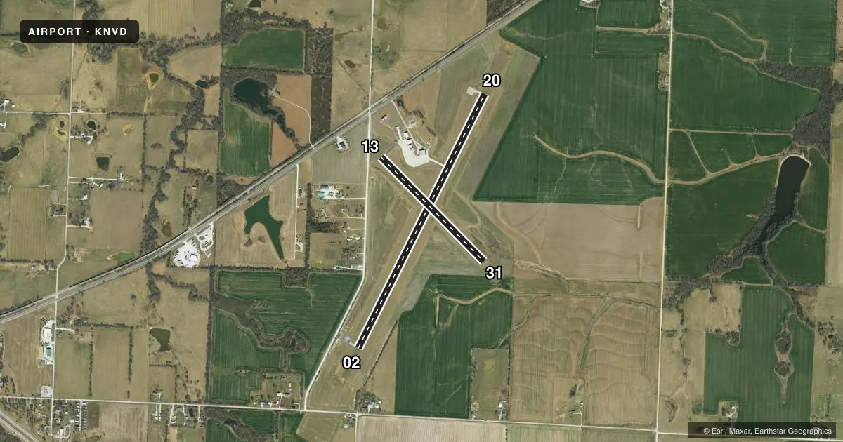
Runways & pattern
Full pagePattern entry · RWY 20
LEFT TRAFFIC| Runway | Heading (°M) | Length | Surface | Traffic |
|---|---|---|---|---|
| 02/20Favored | 24° / 205° | 5,000 ft | CONC | Standard L |
| 13/31 | 133° / 313° | 2,581 ft | ASPH | Standard L |
Runway end performance
| End | TORA | TODA | ASDA | LDA | VGSI | Approach lights | Obstruction |
|---|---|---|---|---|---|---|---|
| 02 | — | — | — | — | PAPI 4-box left(3°) | — | 56', tree, 1210' from thr, 302' R of cntrln, slope 18 |
| 20 | — | — | — | — | PAPI 4-box left(3°) | — | 45', trees, 1365' from thr, 323' R of cntrln, slope 25 |
| 13 | — | — | — | — | — | — | 39', trees, 836' from thr, 170' R of cntrln, slope 16 |
| 31 | — | — | — | — | — | — | 34', trees, 625' from thr, 112' R of cntrln, slope 12 |
Declared distances in feet. TORA = takeoff run available, TODA = takeoff distance, ASDA = accelerate-stop, LDA = landing distance.
Airport sketch
Runways drawn to scale from FAA survey coordinates, rendered over satellite imagery. Not for navigation.
Approaches & charts
Services on the field
Fuel grades, oxygen, maintenance, ramp storage and lighting — as declared to the FAA by the airport operator.
Fuel & services
- Fuel
- 100LLA
- Oxygen (bulk)
- Not available
- Airframe repair
- Minor
- Power plant repair
- Minor
- Other services
- AGRI
Ramp & ground
- Transient storage
- Tie-down
- Landing fee
- No fee published
- Customs
- Not available
- Lighting schedule
- SEE RMK
- Beacon schedule
- SS-SR
- Beacon
- White / Green (civil land)(WG)
- Wind indicator
- Lighted
- Segmented circle
- Yes
Fuel & FBOs
Cheapest 100LL and Jet A on the field and nearby. Always confirm with the FBO before taxi.
Airport notes
Surface conditions, obstructions, local procedures, lighting outages and other notes published with each FAA cycle.
General notes
- WILDLIFE ON & INVOF RY DUSK-DAWN.
- CROP DUSTING ACFT ON & INVOF ARPT.
- FOR CD CTC KANSAS CITY ARTCC AT 913-254-8508.
Lighting notes
- ACTVT REILS RWYS 02 & 20; PAPI RWYS 02 & 20; MIRLS RWY 02/20 AFTER SS - CTAF. REILS RWYS 02 & 20; PAPI RWYS 02 & 20; MIRLS RWYS 02 & 20 NOT AVBL SR - SS.
Runway surface & condition
- 13/31LIMITED BY AMGR TO 8000 LBS SINGLE WHEEL GEAR.
Approach & departure obstructions
- 13COUNTY ROAD 189-483 FT FM RY END 125 FT R AND L.
- 02MARKINGS FADED.
- 20MARKINGS FADED
Other notes
- 13/31RWY 13/31 PAVEMENT CRACKED WITH LOOSE ASPH CHIPS & VEGETATION GROWING IN CRACKS.
VFR map & nearby airports
VFR sectional. Tap any ICAO chip to open that airport.
Key facts · KNVD
Answer card- ICAO
- KNVD
- Name
- NEVADA MUNI
- Location
- NEVADA, MISSOURI
- Elevation
- 892 ft MSL
- Traffic pattern altitude
- 1,892 ft MSL (1,000 AGL)
- Control tower
- Non-towered (use CTAF)
- Total runways
- 2
- Longest runway
- 02/20 · 5,000 ft
- Published ILS approaches
- 0
- Published frequencies
- 2
- Magnetic variation
- 2°
- Current flight rules
- VFR
- Current wind
- 220° at 14 kt
- Favored runway now
- RWY 20
Nevada Muni sits in Nevada, Missouri. Field elevation is 892 ft MSL. The airport has two runways. The longest is runway 02/20 at 5,000 ft. There is no control tower. CTAF and UNICOM are both 122.8.
No ILS approaches are published here. Pattern altitude is not published, so plan on the standard 1,000 ft AGL for light piston traffic unless the current Chart Supplement says otherwise. Aero B Service is on the field. It carries 100LL and Jet A Prist. If you need current fuel or ramp details, call them directly at (417) 448-5107.
A few remarks matter for planning. Runway 20 markings are faded. Runway 02 markings are also faded. Runway 13/31 has cracked pavement, loose asphalt chips and vegetation in the cracks. The airport manager limits runway 13/31 to 8,000 pounds single wheel gear. County Road 189 sits close to the runway 13 end. Crop dusting aircraft operate on and near the airport. Wildlife is also a factor from dusk to dawn. Runway 02/20 has REILs, PAPI and medium intensity lighting after sunset. Those lights are controlled by CTAF. They are not available from sunrise to sunset. For clearance delivery, contact Kansas City ARTCC at 913-254-8508.