METAR & TAF KLLU
KLLU does not publish a METAR.
Showing the nearest reporting station: KPTS (ATKINSON MUNI) · 20.1 NM away. Conditions at KLLU may differ.
METAR · KPTS
Observed 21:15Z
KPTS 272115Z AUTO 23010KT 10SM CLR 38/21 A2983 RMK AO2
- Wind
- 230° @ 10 kt
- Visibility
- 10 SM
- Temp / Dew
- 38°C / 21°C
- Altimeter
- 29.83 inHg
- Clouds
- CLR
- Density alt
- 4,124 ft
- Ceiling
- Unlimited
- Rules
- VFR
Airport info & contacts
Manager on record, flight service, ARTCC, attendance schedule and pattern altitude — published by the FAA and refreshed every 28 days.
Location
- From city
- 2 NM SW
- VFR sectional
- KANSAS CITY
- ARTCC
- ZKC · KANSAS CITY
- NOTAM facility
- COU (NOTAM-D)
Airport manager
- Name
- RUSS WORSLEY
- Phone
- 417-682-5554
- Address
- 132 WEST 10TH, LAMAR MO 64759
Flight service · Hours
- FSS COU
- COLUMBIA1-800-WX-BRIEF
- Attendance
- Unattended
Frequencies
Tap any row to copy the frequency to your clipboard.
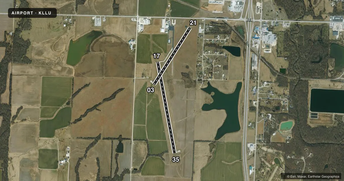
Runways & pattern
Full pagePattern entry · RWY 21
LEFT TRAFFIC| Runway | Heading (°M) | Length | Surface | Traffic |
|---|---|---|---|---|
| 17/35 | 167° / 347° | 4,000 ft | CONC | Standard L |
| 03/21Favored | 31° / 211° | 2,900 ft | ASPH-CONC | Standard L |
Runway end performance
| End | TORA | TODA | ASDA | LDA | VGSI | Approach lights | Obstruction |
|---|---|---|---|---|---|---|---|
| 17 | — | — | — | — | PAPI 4-box left(3°) | — | — |
| 35 | — | — | — | — | PAPI 4-box left(3°) | — | — |
Declared distances in feet. TORA = takeoff run available, TODA = takeoff distance, ASDA = accelerate-stop, LDA = landing distance.
Airport sketch
Runways drawn to scale from FAA survey coordinates, rendered over satellite imagery. Not for navigation.
Approaches & charts
Services on the field
Fuel grades, oxygen, maintenance, ramp storage and lighting — as declared to the FAA by the airport operator.
Fuel & services
- Fuel
- 100LLA
- Oxygen (bottled)
- Not available
- Oxygen (bulk)
- Not available
- Power plant repair
- Not available
- Other services
- AGRI,INSTR,RNTL
Ramp & ground
- Transient storage
- Tie-down
- Landing fee
- No fee published
- Customs
- Not available
- Lighting schedule
- SEE RMK
- Beacon schedule
- SS-SR
- Beacon
- White / Green (civil land)(WG)
- Wind indicator
- Lighted
- Segmented circle
- Yes
Fuel & FBOs
Cheapest 100LL and Jet A on the field and nearby. Always confirm with the FBO before taxi.
Airport notes
Surface conditions, obstructions, local procedures, lighting outages and other notes published with each FAA cycle.
General notes
- FOR CD CTC KANSAS CITY ARTCC AT 913-254-8508.
Lighting notes
- ACTVT MIRL RYS 03/21 & 17/35, PAPI RYS 17 & 35 - CTAF.
- ULTRALIGHT ACTIVITY ON & INVOF ARPT.
Fuel notes
- 100LLFOR FUEL CTC NUMBER POSTED AT FUELING AREA.
VFR map & nearby airports
VFR sectional. Tap any ICAO chip to open that airport.
Key facts · KLLU
Answer card- ICAO
- KLLU
- Name
- LAMAR MUNI
- Location
- LAMAR, MISSOURI
- Elevation
- 1,009.8 ft MSL
- Traffic pattern altitude
- 2,009.8 ft MSL (1,000 AGL)
- Control tower
- Non-towered (use CTAF)
- Total runways
- 2
- Longest runway
- 17/35 · 4,000 ft
- Published ILS approaches
- 0
- Published frequencies
- 1
- Magnetic variation
- 2°
- Current flight rules
- VFR
- Current wind
- 230° at 10 kt
- Favored runway now
- RWY 21
Lamar Muni sits in Lamar, Missouri. The field elevation is 1,009.8 ft MSL. It has two runways. The longest is 4,000 ft on 17/35. Runway 03/21 is 2,900 ft. There is no control tower. CTAF is 122.9. No ILS approaches are published here.
Pattern altitude is not published. Use the standard 1,000 ft AGL for light piston traffic unless the current Chart Supplement says otherwise. Ultralight activity occurs on and near the airport, so keep a sharp scan in the pattern and on final. Medium intensity runway lights are active on both runways. PAPI is installed on 17 and 35. That helps on night arrivals or when the field is busy.
MBMB is on the field. It carries 100LL and Jet A. For fuel, use the number posted at the fueling area or call (417) 483-7729 before arrival. For clearance delivery, Kansas City ARTCC can be reached at 913-254-8508. This is a non-towered field, so plan your calls early and stay disciplined on CTAF. Check the current Chart Supplement for any published noise or curfew restrictions before flying in.